- Zalacsány Airport
Last updated: 2026.10.01.
1. Aerodrome identification
- Aerodrome location indicator
- -
- Aerodrome name
- Zalacsány Airport
- Aerodrome place name
- Zalacsány
2. Contact
- Address
- 8782 Zalacsány, Külterület, Hrsz. 063/10
- Phone
- +36-30/937-4640
- repcsi90@gmail.com
3. Gallery
Teljes képernyő
Teljes
képernyő bezárása
Teljes képernyő
Teljes
képernyő bezárása
5. Aerodrome geographical and administrative data
ARP data
- Coordinates
- 464803N 0170640E
- Site at aerodrome
- In front of the hangar
Location of aerodrome
- Distance from city (KM)
- Zalacsány 1 KM
- Direction from city
- 90°
- Elevation
- 373 FT
Magnetic variation data
- Degree of magnetic variation ( °)
- 5°15' E
- Annual change ( °)
- +0°09'
- Year of survey
- 2024
Aerodrome operator data
- Name
- Ambrus Szilárd
- Address
- 8360 Keszthely, Munkás u. 17.
- Phone
- +36-30/937-4640
- Fax
- NIL
- Web
- NIL
- repcsi90@gmail.com
Aerodrome data
- Name
- 8782 Zalacsány, Külterület, Hrsz. 063/10
- Phone
- +36-30/937-4640 (Ambrus Szilárd)
- Fax
- NIL
- Web
- NIL
- repcsi90@gmail.com
- AFS
- NIL
- SITA
- NIL
- Others
- NIL
- Type of traffic allowed at the aerodrome
- VFR
- Remarks
- Special civil airport, For the exclusive use of the owner/operator at his/her discretion.
- Name of responsible manager
- Ambrus Szilárd
- Hours of service
- A repülőtér csak az üzembentartó előzetes engedélye alapján használható, nyitvatartási időn belül.
6. Air traffic services communication facitlities
|
Service designation
|
Call sign
|
Channel
|
Languages used
|
Hours of operation
|
Remarks
|
|---|---|---|---|---|---|
| NIL | NIL | NIL | NIL | NIL | NIL |
7. Operation hours
- AD Administration
- SR - SS, in VFR conditions, on snow-free days
- Customs and immigration
- NIL
- Health and sanitation
- NIL
- AIS Briefing Office
- NIL
- ATS Reporting Office (ARO)
- NIL
- MET Briefing Office
- NIL
- ATS
- NIL
- Fuelling
- NIL
- Handling
- NIL
- Security
- NIL
- De-icing
- NIL
- Remarks
- NIL
8. Available handling services and facilities
- Cargo-handling facilities
- NIL
- Fuel types
- NIL
- Oil types
- NIL
- Fuelling facilities and capacity
- NIL
- De-icing facilities
- NIL
- Hangar space for visiting aircraft
- For the owner only
- Repair facilities for visiting aircraft
- NIL
- Remarks
- NIL
9. Passenger facilities
- Hotels
- NIL
- Restaurants
- NIL
- Transportation
- NIL
- Medical facilities
- NIL
- Bank and Post Office
- NIL
- Tourist Office
- NIL
- Remarks
- NIL
10. Available rescue and fire fighting services
- Aerodrome catogory for fire fighting
- Category 1 as defined in Annex 3 to Government Decree 85/2024 (IV.17)
- Available rescue and fire fighting services
- NIL
- Rescue and fire fighting equipment
- Fire extinguishers and equipment in category 1 of Annex 3 of Government Decree 85/2024 (IV.17).
- Capability for removal of disabled aircraft
- NIL
- Remarks
- NIL
11. Clearing
- Types of clearing equipment
- NIL
- Clearance priorities
- NIL
- Remarks
- The airport operates only on snow-free days.
12. Aprons
|
Designation
|
Surface
|
Strength
|
Remarks
|
Designator
|
|---|---|---|---|---|
| NIL | NIL | NIL | NIL | NIL |
13. Taxiways
|
Designation
|
Surface
|
Strength
|
Width (M)
|
Remarks
|
Designatior
|
|---|---|---|---|---|---|
| NIL | NIL | NIL | NIL | NIL | NIL |
14. Checkpoints
Altimeter checkpoints and locations data
- Coordinates
- NIL
- Technical data
- NIL
- VOR checkpoints
- NIL
- INS checkpoints
- NIL
- Remarks
- NIL
15. Surface movement guidance and control system and markings
- Use of aircraft stand ID signs, TWY guide lines and visual docking/parking guidance system of aircraft stands
- NIL
- RWY and TWY markings and lighting
- RWY threshold signs, edge signsLighting: NIL
- Stop bars
- NIL
- Remarks
- NIL
16. Runways (RWY)
|
RWY designator
|
True bearing
|
Magnetic bearing
|
Length (M)
|
Width (M)
|
Strength
|
Surface
|
Remarks
|
|---|---|---|---|---|---|---|---|
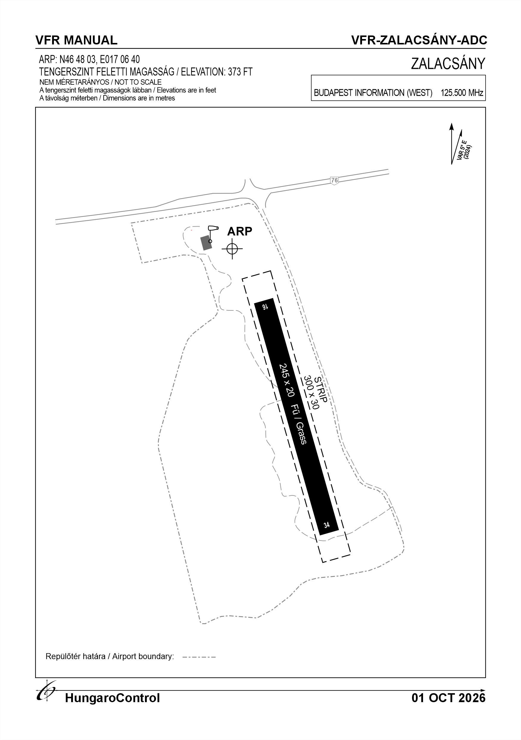
| 16 | 165° | 160° | 245 | 20 | 5 t (2 t) | Grass | NIL |
| 34 | 345° | 340° | 245 | 20 | 5 t (2 t) | Grass | NIL |
17. Aerodrome obstacles
18. Stopways (SWY)
|
RWY designator
|
Length (M)
|
Width (M)
|
Strength
|
Surface
|
Slope (%)
|
Remarks
|
|---|---|---|---|---|---|---|
| 16 | NIL | NIL | NIL | NIL | NIL | NIL |
| 34 | NIL | NIL | NIL | NIL | NIL | NIL |
19. Clearways (CWY)
|
RWY designator
|
Length (M)
|
Width (M)
|
Slope (%)
|
Remarks
|
|---|---|---|---|---|
| 16 | NIL | NIL | NIL | NIL |
| 34 | NIL | NIL | NIL | NIL |
20. STRIP
|
RWY designator
|
Length (M)
|
Width (M)
|
Remarks
|
|---|---|---|---|
| 16 | 300 | 30 | Grass |
| 34 | 300 | 30 | Grass |
21. RESA
|
RWY designator
|
Length (M)
|
Width (M)
|
Surface
|
Obstacle free zone (OFZ)
|
Remarks
|
|---|---|---|---|---|---|
| 16 | NIL | NIL | NIL | NIL | NIL |
| 34 | NIL | NIL | NIL | NIL | NIL |
22. Declared distances
|
RWY designator
|
TORA (M)
|
TODA (M)
|
ASDA (M)
|
LDA (M)
|
Remarks
|
|---|---|---|---|---|---|
| 16 | 245 | 245 | 245 | 245 | NIL |
| 34 | 245 | 245 | 245 | 245 | NIL |
23. Approach lighting
|
RWY designator
|
Type
|
Length (M)
|
Intensity
|
Remarks
|
|---|---|---|---|---|
| 16 | NIL | NIL | NIL | NIL |
| 34 | NIL | NIL | NIL | NIL |
24. Threshold lighting
|
RWY designator
|
Colour
|
Wing bar lights
|
Remarks
|
|---|---|---|---|
| 16 | NIL | NIL | NIL |
| 34 | NIL | NIL | NIL |
25. Visual approach slope indicator system lighting
|
RWY designator
|
Type
|
Data
|
Remarks
|
|---|---|---|---|
| 16 | NIL | NIL | NIL |
| 34 | NIL | NIL | NIL |
26. Touchdone zone lighting
|
RWY designator
|
Length of lighting (M)
|
Remarks
|
|---|---|---|
| 16 | NIL | NIL |
| 34 | NIL | NIL |
27. Runway centreline lighting
|
RWY designator
|
Length (M)
|
Spacing (M)
|
Colour
|
Intensity
|
Remarks
|
|---|---|---|---|---|---|
| 16 | NIL | NIL | NIL | NIL | NIL |
| 34 | NIL | NIL | NIL | NIL | NIL |
28. Runway edgeline lighting
|
RWY designator
|
Length (M)
|
Spacing (M)
|
Colour
|
Intensity
|
Remarks
|
|---|---|---|---|---|---|
| 16 | NIL | NIL | NIL | NIL | NIL |
| 34 | NIL | NIL | NIL | NIL | NIL |
29. Runway end lighting
|
RWY designator
|
Colour
|
Remarks
|
|---|---|---|
| 16 | NIL | NIL |
| 34 | NIL | NIL |
30. Runway wing bars lighting
|
RWY designator
|
Colour
|
Remarks
|
|---|---|---|
| 16 | NIL | NIL |
| 34 | NIL | NIL |
31. Stopway lighting
|
RWY designator
|
Length of lighting (M)
|
Colour
|
Remarks
|
|---|---|---|---|
| 16 | NIL | NIL | NIL |
| 34 | NIL | NIL | NIL |
32. Other lighting, secondary power supply
- ABN/IBN location, charasteristics and hours of operation
- NIL
- LDI location and lighting
- The roof of the hangar, without lighting
- Anemometer location and lighting
- NIL
- 4Centre line lighting
- NIL
- TWY edge line lighting
- NIL
- Secondary power supply
- NIL
- Switch-over time
- NIL
- Remarks
- NIL
33. Helicopter landing area
- Coordinates TLOF or THR of FATO
- NIL
- TLOF and/or FATO elevation
- NIL
- TLOF and FATO area marking
- NIL
- TLOF and FATO area dimensions (M)
- NIL
- TLOF and FATO area surface
- NIL
- TLOF and FATO area strength
- NIL
- True BRG of FATO
- NIL
- MAG BRG of FATO
- NIL
- Declared distances available
- NIL
- APP and FATO lighting
- NIL
- Remarks
- NIL
34. Meteorological information provider
- Associated MET Office
- HungaroMet Magyar Meteorológiai Szolgáltató Nonprofit Zrt. (HungaroMet Zrt.), Unit of Aviation Meteorology
- Hours of service
- H24
- Office responsible for TAF preparation
- HungaroMet Magyar Meteorológiai Szolgáltató Nonprofit Zrt. (HungaroMet Zrt.), Unit of Aviation Meteorology
- Periods of validity
- NIL
- Interval of issuance
- NIL
- Type of landing forecast
- NIL
- Landing forecast interval of issuance
- NIL
- Briefing/consultation provided
- Written briefing: https://aviation.met.hu;Consultation via phone: +36-90/603-424;Consultation via e-mail: rvo@met.hu;
- Flight documentation
- Charts, abbreviated plain language text
- Language(s) used
- HU, EN
- Charts and other information available for briefing or consultation
- Charts, aerodrome reports and forecasts in EUR region, area forecasts, MET. observations and warnings in Budapest FIR
- Supplementary equipment available for providing information
- Self-briefing via aviation.met.hu
- ATS Units provided with information
- Budapest FIC (on request)
- Remarks
- NIL
35. Air traffic service airspace
- Designation
- NIL
- Lateral limits
- NIL
- Vertical limits (FT)
- NIL
- Airspace classification
- NIL
- ATS unit call sign
- NIL
- Languages used
- NIL
- Transition altitude (FT)
- NIL
- Remarks
- NIL
37. Local aerodrome regulations
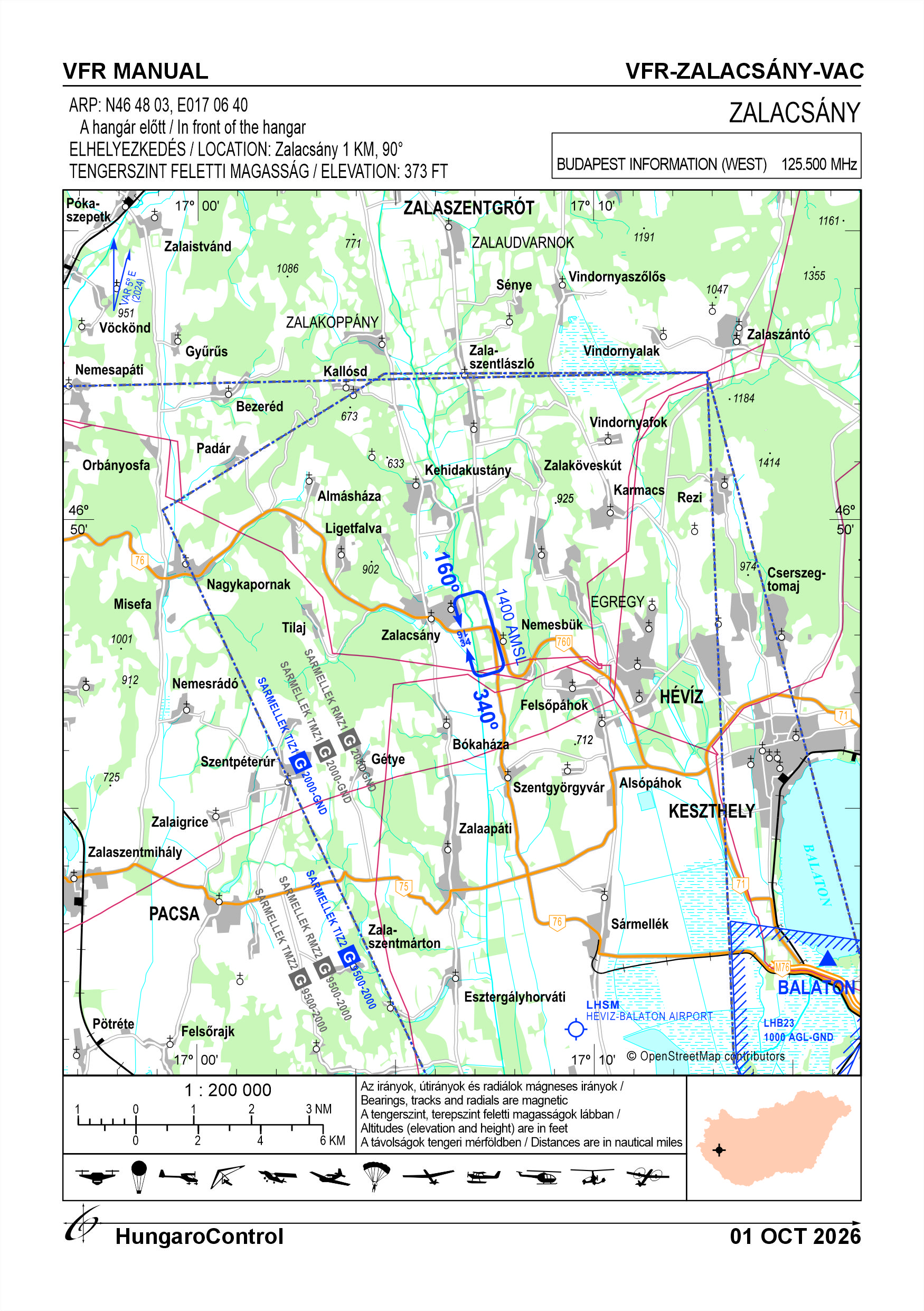
Zalacsány Airport is located below the Sármellék TIZ. The AFIS in Sármellék must be kept informed of traffic in Zalacsány at all times, and must therefore be able to exchange information: - the take-off from Zalacsány is considered as an entry into the Sármellék TIZ, therefore a radio contact with the Sármellék AFIS on 134.585 MHz must be established before take-off, to coordinate the flight plan, both for local flights or school circuits; - keep in continuous radio contact with the Mudflats AFIS; - other frequencies to be used outside the TIZ only. The coordination of daily operations is organised on a daily basis by the manager in charge or his deputy, depending on the weather and the operation or operations. The traffic circle altitude is 1400 feet AMSL. The traffic circle direction is 16 left, 34 right. Engine starts shall be commenced with caution and with due regard to the safety of persons and the flotation of objects. Anchor outside the runway. Aircraft must be manually propelled if justified, otherwise they must be propelled by their own powerplant. Except in the case of landing and take-off at the airport and in cases specifically authorised by the competent authority, VFR flights shall not be performed: 1) over densely populated areas of cities, towns or groups of people in the open air, below 300 metres (1 000 feet) above the highest obstacle within a radius of 600 metres (1 000 m) of the aircraft; 2) in areas other than those referred to in point 1, below 150 metres (500 feet) above the surface of land or water. Wildlife Hazard Management The operational area of the aerodrome is not enclosed by a perimeter fence designed to prevent unauthorized access. Three sides of the aerodrome are bordered by reed beds, which may serve as habitats for waterfowl, while a public road runs on an elevated embankment near threshold 16. The presence of wild animals on the aerodrome cannot therefore be excluded. The aerodrome area provides good overall visibility. Prior to the commencement of operations and occasionally during operations, the aerodrome operator carries out inspections and, in the event of a hazard, immediately informs the pilots of aircraft on the ground. Pilots shall pay particular attention to the possible presence of wildlife during take-off and landing. Before landing, pilots may also verify the presence of animals on or near the aerodrome by overflying the aerodrome, if necessary repeatedly, prior to the approach and landing. For further information, see the current Airport Order.
Activities at the airport (Yes / No)
- Unmanned aerial vehicle (D)
- Yes
- Ballon (B)
- Yes
- Ultralight (U)
- Yes
- Hang glider (N)
- Yes
- Short take-off and landing (R)
- Yes
- Landplane (L)
- Yes
- Paraglider (P)
- Yes
- Glider (G)
- Yes
- Amphibian (A)
- Yes
- Helicopter (H)
- Yes
- Gyrocopter (G)
- Yes
- Tilt-wing aircraft (T)
- Yes
- Other (O)
- Yes
38. Noise abatement procedures
Avoid flying over surrounding settlements. No idling of engines, operation of auxiliary power units, operation of various charging aggregators, engine testing during maintenance is permitted at the airport, except for the required pre-take-off engine test, which must be performed on the runway and is therefore equivalent to noise during take-off.
39. Aerodrome charges
There is no charge, but the airport can only be used with prior operator permission.
40. Additional information
For more information, see the Airport Rules.
41. Aerodrome obstacles
- No obstacle text
- NIL
- RWY designator
- NIL
- Obstacle type
- NIL
- Elevation
- NIL
- Height
- NIL
- Coordinates
- NIL
- Remarks
- NIL