- Rétság Repülőtér
Last updated: 2026.03.19.
1. Aerodrome identification
- Aerodrome location indicator
- -
- Aerodrome name
- Rétság Repülőtér
- Aerodrome place name
- Tolmács
2. Contact
- Address
- 2651 Tolmács, hrsz.: 02/11
- Phone
- +36-20/428-1078
- info@ul-talalkozo.hu
3. Gallery
Teljes képernyő
Teljes
képernyő bezárása
Teljes képernyő
Teljes
képernyő bezárása
5. Aerodrome geographical and administrative data
ARP data
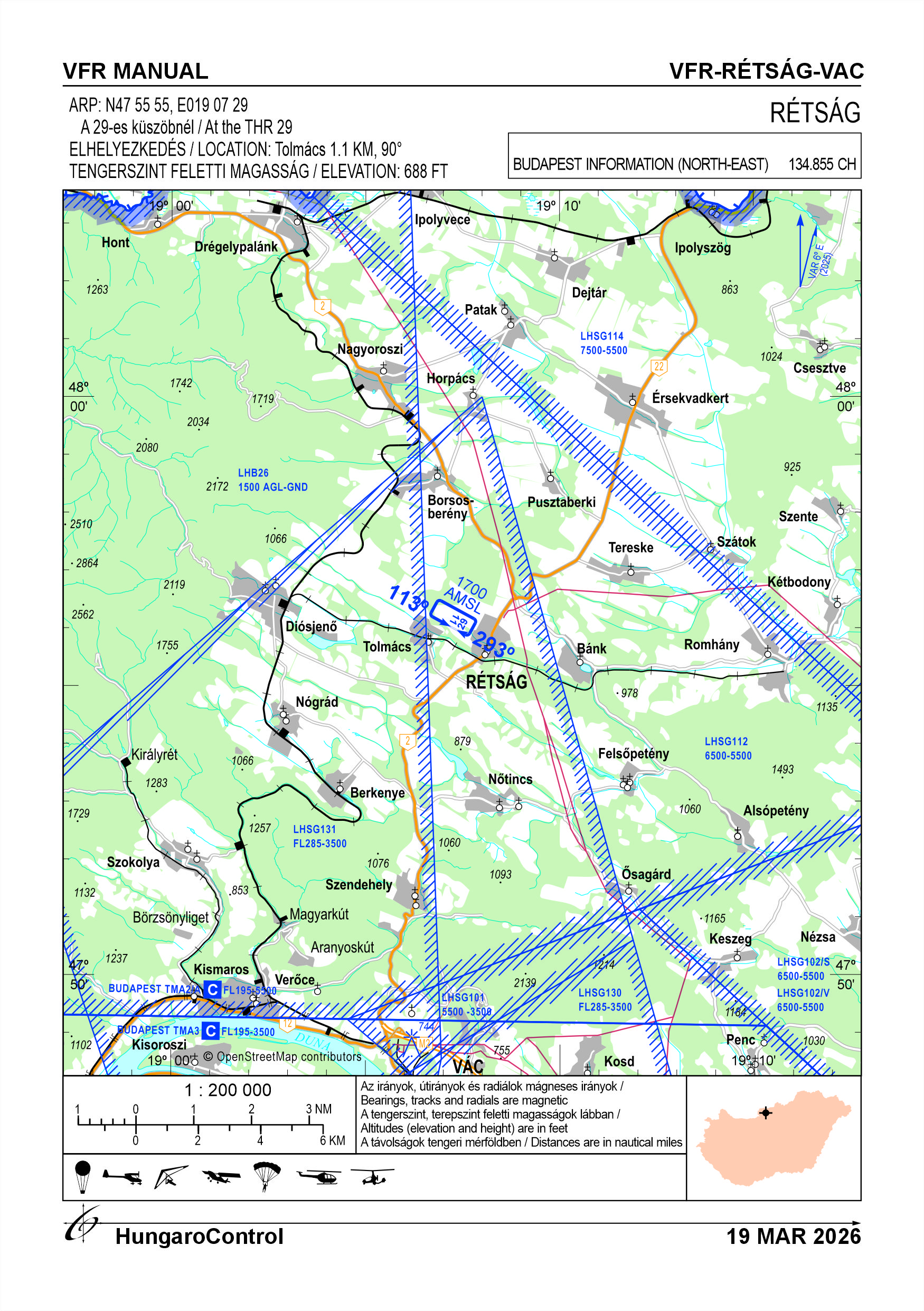
- Coordinates
- 475555N 0190729E
- Site at aerodrome
- At the THR 29
Location of aerodrome
- Distance from city (KM)
- Tolmács 1.1 KM
- Direction from city
- 90°
- Elevation
- 688 FT
Magnetic variation data
- Degree of magnetic variation ( °)
- 5°47' E
- Annual change ( °)
- +0°09'
- Year of survey
- 2024
Aerodrome operator data
- Name
- Extrém Légisport Egyesület
- Address
- 5651 Rétság, Szőlő utca 28.
- Phone
- +36-20/428-1078
- Fax
- NIL
- info@ul-talalkozo.hu
Aerodrome data
- Name
- 2651 Tolmács, hrsz.: 02/11
- Phone
- +36-20/428-1078 (Keserű Lászlóné)
- Fax
- NIL
- info@ul-talalkozo.hu
- AFS
- NIL
- SITA
- NIL
- Others
- NIL
- Type of traffic allowed at the aerodrome
- VFR
- Remarks
- Special airport for civil use, Only PPR
- Responsible operator's name
- NIL
- Time logged
- NIL
6. Air traffic services communication facitlities
|
Service designation
|
Call sign
|
Channel
|
Languages used
|
Hours of operation
|
Remarks
|
|---|---|---|---|---|---|
| NIL | NIL | NIL | NIL | NIL | NIL |
7. Operation hours
- AD Administration
- From 15th of March to 15th of September: 6:00-20:00 LT From 16th of September to 14th of March: 8:00-17:00 LTOn snow-free days
- Customs and immigration
- NIL
- Health and sanitation
- NIL
- AIS Briefing Office
- NIL
- ATS Reporting Office (ARO)
- NIL
- MET Briefing Office
- NIL
- ATS
- NIL
- Fuelling
- NIL
- Handling
- NIL
- Security
- NIL
- De-icing
- NIL
- Remarks
- NIL
8. Available handling services and facilities
- Cargo-handling facilities
- NIL
- Fuel types
- NIL
- Oil types
- NIL
- Fuelling facilities and capacity
- NIL
- De-icing facilities
- NIL
- Hangar space for visiting aircraft
- NIL
- Repair facilities for visiting aircraft
- NIL
- Remarks
- NIL
9. Passenger facilities
- Hotels
- NIL
- Restaurants
- NIL
- Transportation
- NIL
- Medical facilities
- NIL
- Bank and Post Office
- NIL
- Tourist Office
- NIL
- Remarks
- NIL
10. Available rescue and fire fighting services
- Aerodrome catogory for fire fighting
- Category 1 as defined in Annex 3 to Government Decree 85/2024 (IV.17).
- Available rescue and fire fighting services
- NIL
- Rescue and fire fighting equipment
- 4 pcs 6 kg 55A 233 B, C powder extinguishers Tools, equipment: 1 general ladder (for rescue) 1 box of AIDS gloves 1 95 cm crowbar 1 heavy-duty hacksaw with spare blades 1 axe 1 1.8 kg hammer 1 shovel or 1 shovel and 1 shovel 1 pair of 1.6 cm cutting edge pliers 1 20 cm combination pliers 1 25 cm pipe/water pump pliers 1 first aid kit for category "C" vehicles
- Capability for removal of disabled aircraft
- NIL
- Remarks
- NIL
11. Clearing
- Types of clearing equipment
- NIL
- Clearance priorities
- NIL
- Remarks
- NIL
12. Aprons
|
Designation
|
Surface
|
Strength
|
Remarks
|
Designator
|
|---|---|---|---|---|
| NIL | NIL | NIL | NIL | NIL |
13. Taxiways
|
Designation
|
Surface
|
Strength
|
Width (M)
|
Remarks
|
Designatior
|
|---|---|---|---|---|---|
| NIL | NIL | NIL | NIL | NIL | NIL |
14. Checkpoints
Altimeter checkpoints and locations data
- Coordinates
- NIL
- Technical data
- NIL
- VOR checkpoints
- NIL
- INS checkpoints
- NIL
- Remarks
- NIL
15. Surface movement guidance and control system and markings
- Use of aircraft stand ID signs, TWY guide lines and visual docking/parking guidance system of aircraft stands
- NIL
- RWY and TWY markings and lighting
- RWY threshold signs, edge signs
- Stop bars
- NIL
- Remarks
- NIL
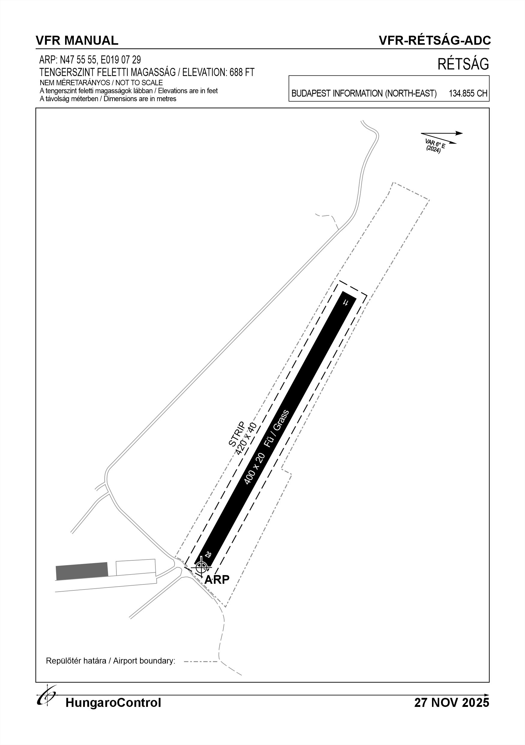
16. Runways (RWY)
|
RWY designator
|
True bearing
|
Magnetic bearing
|
Length (M)
|
Width (M)
|
Strength
|
Surface
|
Remarks
|
|---|---|---|---|---|---|---|---|
| 11 | 119° | 113° | 400 | 20 | 6 t (2 t) | Grass | NIL |
| 29 | 299° | 293° | 400 | 20 | 6 t (2 t) | Grass | NIL |
17. Aerodrome obstacles
18. Stopways (SWY)
|
RWY designator
|
Length (M)
|
Width (M)
|
Strength
|
Surface
|
Slope (%)
|
Remarks
|
|---|---|---|---|---|---|---|
| 11 | NIL | NIL | NIL | NIL | NIL | NIL |
| 29 | NIL | NIL | NIL | NIL | NIL | NIL |
19. Clearways (CWY)
|
RWY designator
|
Length (M)
|
Width (M)
|
Slope (%)
|
Remarks
|
|---|---|---|---|---|
| 11 | NIL | NIL | NIL | NIL |
| 29 | NIL | NIL | NIL | NIL |
20. STRIP
|
RWY designator
|
Length (M)
|
Width (M)
|
Remarks
|
|---|---|---|---|
| 11 | 420 | 40 | NIL |
| 29 | 420 | 40 | NIL |
21. RESA
|
RWY designator
|
Length (M)
|
Width (M)
|
Surface
|
Obstacle free zone (OFZ)
|
Remarks
|
|---|---|---|---|---|---|
| 11 | NIL | NIL | NIL | NIL | NIL |
| 29 | NIL | NIL | NIL | NIL | NIL |
22. Declared distances
|
RWY designator
|
TORA (M)
|
TODA (M)
|
ASDA (M)
|
LDA (M)
|
Remarks
|
|---|---|---|---|---|---|
| 11 | 400 | 400 | 400 | 400 | NIL |
| 29 | 400 | 400 | 400 | 400 | NIL |
23. Approach lighting
|
RWY designator
|
Type
|
Length (M)
|
Intensity
|
Remarks
|
|---|---|---|---|---|
| 11 | NIL | NIL | NIL | NIL |
| 29 | NIL | NIL | NIL | NIL |
24. Threshold lighting
|
RWY designator
|
Colour
|
Wing bar lights
|
Remarks
|
|---|---|---|---|
| 11 | NIL | NIL | NIL |
| 29 | NIL | NIL | NIL |
25. Visual approach slope indicator system lighting
|
RWY designator
|
Type
|
Data
|
Remarks
|
|---|---|---|---|
| 11 | NIL | NIL | NIL |
| 29 | NIL | NIL | NIL |
26. Touchdone zone lighting
|
RWY designator
|
Length of lighting (M)
|
Remarks
|
|---|---|---|
| 11 | NIL | NIL |
| 29 | NIL | NIL |
27. Runway centreline lighting
|
RWY designator
|
Length (M)
|
Spacing (M)
|
Colour
|
Intensity
|
Remarks
|
|---|---|---|---|---|---|
| 11 | NIL | NIL | NIL | NIL | NIL |
| 29 | NIL | NIL | NIL | NIL | NIL |
28. Runway edgeline lighting
|
RWY designator
|
Length (M)
|
Spacing (M)
|
Colour
|
Intensity
|
Remarks
|
|---|---|---|---|---|---|
| 11 | NIL | NIL | NIL | NIL | NIL |
| 29 | NIL | NIL | NIL | NIL | NIL |
29. Runway end lighting
|
RWY designator
|
Colour
|
Remarks
|
|---|---|---|
| 11 | NIL | NIL |
| 29 | NIL | NIL |
30. Runway wing bars lighting
|
RWY designator
|
Colour
|
Remarks
|
|---|---|---|
| 11 | NIL | NIL |
| 29 | NIL | NIL |
31. Stopway lighting
|
RWY designator
|
Length of lighting (M)
|
Colour
|
Remarks
|
|---|---|---|---|
| 11 | NIL | NIL | NIL |
| 29 | NIL | NIL | NIL |
32. Other lighting, secondary power supply
- ABN/IBN location, charasteristics and hours of operation
- NIL
- LDI location and lighting
- NIL
- Anemometer location and lighting
- NIL
- 4Centre line lighting
- NIL
- TWY edge line lighting
- NIL
- Secondary power supply
- NIL
- Switch-over time
- NIL
- Remarks
- NIL
33. Helicopter landing area
- Coordinates TLOF or THR of FATO
- NIL
- TLOF and/or FATO elevation
- NIL
- TLOF and FATO area marking
- NIL
- TLOF and FATO area dimensions (M)
- NIL
- TLOF and FATO area surface
- NIL
- TLOF and FATO area strength
- NIL
- True BRG of FATO
- NIL
- MAG BRG of FATO
- NIL
- Declared distances available
- NIL
- APP and FATO lighting
- NIL
- Remarks
- NIL
34. Meteorological information provider
- Associated MET Office
- HungaroMet Magyar Meteorológiai Szolgáltató Nonprofit Zrt. (HungaroMet Zrt.), Unit of Aviation Meteorology
- Hours of service
- H24
- Office responsible for TAF preparation
- HungaroMet Magyar Meteorológiai Szolgáltató Nonprofit Zrt. (HungaroMet Zrt.), Unit of Aviation Meteorology
- Periods of validity
- NIL
- Interval of issuance
- NIL
- Type of landing forecast
- NIL
- Landing forecast interval of issuance
- NIL
- Briefing/consultation provided
- Written briefing: https://aviation.met.hu;Consultation via phone: +36-90/603-424;Consultation via e-mail: rvo@met.hu;
- Flight documentation
- Charts, abbreviated plain language text
- Language(s) used
- HU, EN
- Charts and other information available for briefing or consultation
- Charts, aerodrome reports and forecasts in EUR region, area forecasts, MET. observations and warnings in Budapest FIR
- Supplementary equipment available for providing information
- Self-briefing via aviation.met.hu
- ATS Units provided with information
- Budapest FIC (on request)
- Remarks
- NIL
35. Air traffic service airspace
- Designation
- NIL
- Lateral limits
- NIL
- Vertical limits (FT)
- NIL
- Airspace classification
- NIL
- ATS unit call sign
- NIL
- Languages used
- NIL
- Transition altitude (FT)
- NIL
- Remarks
- NIL
37. Local aerodrome regulations
Flight Procedures Daily operations are coordinated by the responsible manager or his/her deputy on a daily basis, depending on weather and the flight operation or operations. From the airport, the flight can take off in 11 directions to the left, and in 29 directions to the right. For 29 directions, the first turn must be made immediately upon reaching a safe altitude, as LHB26 restricted airspace cannot be used from the edge of the forest. Traffic circles are at 1700 ft AMSL for powered fixed-wing aircraft. For unpowered aircraft and aircraft not equipped with an engine, at a height of reasonable altitude. Only aircraft whose commander has been authorised by the operator to use the airport may use the airport. The operator will endeavour to keep wildlife out, but their presence cannot be excluded. For further information, see the current Airport Rules.
Activities at the airport (Yes / No)
- Unmanned aerial vehicle (D)
- No
- Ballon (B)
- Yes
- Ultralight (U)
- Yes
- Hang glider (N)
- Yes
- Short take-off and landing (R)
- Yes
- Landplane (L)
- No
- Paraglider (P)
- Yes
- Glider (G)
- No
- Amphibian (A)
- No
- Helicopter (H)
- Yes
- Gyrocopter (G)
- Yes
- Tilt-wing aircraft (T)
- No
- Other (O)
- No
38. Noise abatement procedures
School districts may only be flown on the opposite side of the settlement. To reduce noise from ground operations, procedures will be implemented for idling engines, operating auxiliary power units, operating various charging aggregators. Engine testing may only take place outside of rest periods with the permission of the operator.
39. Aerodrome charges
No fee
40. Additional information
For more information, see the Airport Rules.
41. Aerodrome obstacles
- No obstacle text
- NIL
- RWY designator
- NIL
- Obstacle type
- NIL
- Elevation
- NIL
- Height
- NIL
- Coordinates
- NIL
- Remarks
- NIL