- Dunabogdány Airport
Last updated: 2026.10.01.
1. Aerodrome identification
- Aerodrome location indicator
- -
- Aerodrome name
- Dunabogdány Airport
- Aerodrome place name
- Dunabogdány
2. Contact
- Address
- 2023 Dunabogdány, Hrsz. 0179/318
- Phone
- +36-20/439-0140
- aeroglobus.rse@gmail.com
3. Gallery
Teljes képernyő
Teljes
képernyő bezárása
Teljes képernyő
Teljes
képernyő bezárása
Teljes képernyő
Teljes
képernyő bezárása
Teljes képernyő
Teljes
képernyő bezárása
Teljes képernyő
Teljes
képernyő bezárása
Teljes képernyő
Teljes
képernyő bezárása
Teljes képernyő
Teljes
képernyő bezárása
Teljes képernyő
Teljes
képernyő bezárása
5. Aerodrome geographical and administrative data
ARP data
- Coordinates
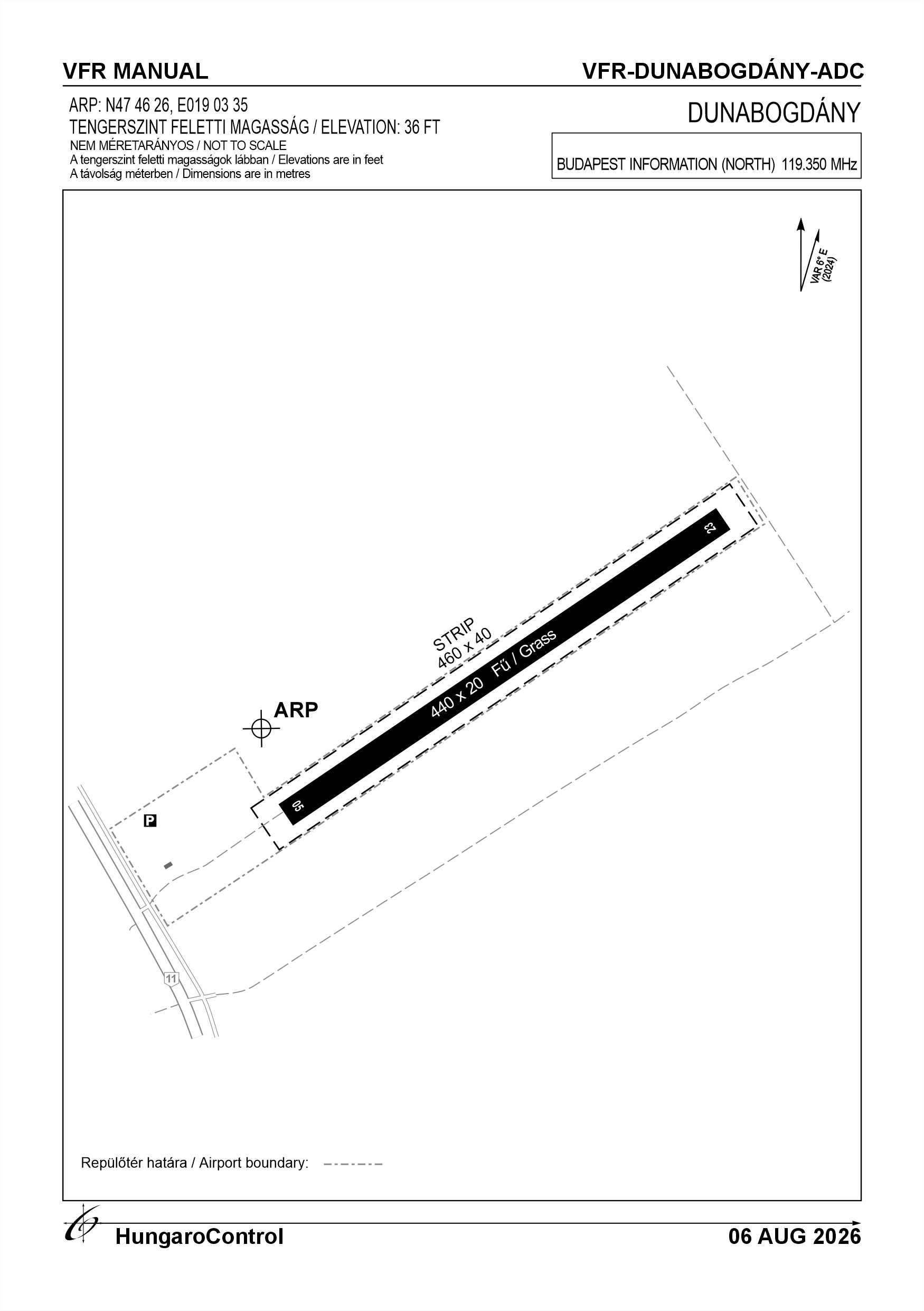
- 474626N 0190335E
- Site at aerodrome
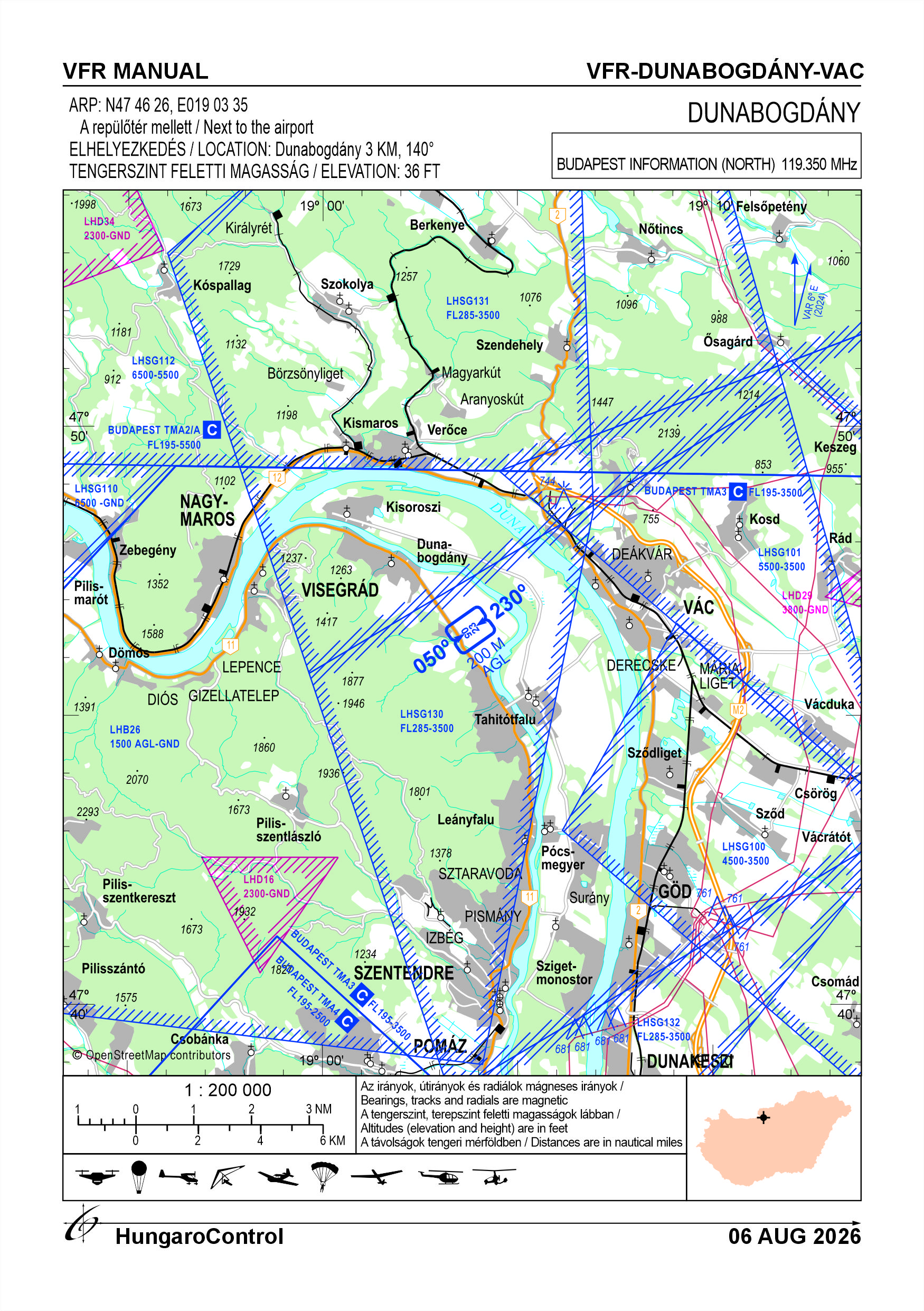
- Next to the airport
Location of aerodrome
- Distance from city (KM)
- Dunabogdány 3 KM
- Direction from city
- 140°
- Elevation
- 36 FT
Magnetic variation data
- Degree of magnetic variation ( °)
- 5.8° E
- Annual change ( °)
- +0.14°
- Year of survey
- 2024
Aerodrome operator data
- Name
- Aeroglobus Repülő SE
- Address
- 2023 Dunabogdány, Kossuth Lajos u. 3.
- Phone
- +36-20/439-0140
- Fax
- NIL
- aeroglobus.rse@gmail.com
Aerodrome data
- Name
- 2023 Dunabogdány, Hrsz. 0179/318
- Phone
- +36-20/439-0140 (Szabó Kálmán)
- Fax
- NIL
- aeroglobus.rse@gmail.com
- AFS
- NIL
- SITA
- NIL
- Others
- NIL
- Type of traffic allowed at the aerodrome
- VFR
- Remarks
- Special airport for civil use
- Name of responsible manager
- Szabó Kálmán
- Hours of service
- VFR körülmények között, az üzembentartó előzetes engedélyével, napkeltétől-napnyugtáig
6. Air traffic services communication facitlities
|
Service designation
|
Call sign
|
Channel
|
Languages used
|
Hours of operation
|
Remarks
|
|---|---|---|---|---|---|
| NIL | NIL | NIL | NIL | NIL | NIL |
7. Operation hours
- AD Administration
- SR - SS, on snow-free days
- Customs and immigration
- NIL
- Health and sanitation
- NIL
- AIS Briefing Office
- NIL
- ATS Reporting Office (ARO)
- NIL
- MET Briefing Office
- NIL
- ATS
- NIL
- Fuelling
- NIL
- Handling
- NIL
- Security
- NIL
- De-icing
- NIL
- Remarks
- Occasional use of the airport on snow-free days in winter
8. Available handling services and facilities
- Cargo-handling facilities
- NIL
- Fuel types
- NIL
- Oil types
- NIL
- Fuelling facilities and capacity
- NIL
- De-icing facilities
- NIL
- Hangar space for visiting aircraft
- NIL
- Repair facilities for visiting aircraft
- NIL
- Remarks
- NIL
9. Passenger facilities
- Hotels
- NIL
- Restaurants
- NIL
- Transportation
- NIL
- Medical facilities
- NIL
- Bank and Post Office
- NIL
- Tourist Office
- NIL
- Remarks
- NIL
10. Available rescue and fire fighting services
- Aerodrome catogory for fire fighting
- Category 1 as defined in Annex 3 to Government Decree 85/2024 (IV.17).
- Available rescue and fire fighting services
- NIL
- Rescue and fire fighting equipment
- Fire extinguisher(s) with an extinguishing capacity of 48 extinguishing units, as defined in BM Decree 54/2014 (XII. 5.) on the National Fire Protection Regulations (hereinafter: BM Decree 54/2014), which are suitable for extinguishing at least class A, B and C fires.
- Capability for removal of disabled aircraft
- NIL
- Remarks
- NIL
11. Clearing
- Types of clearing equipment
- NIL
- Clearance priorities
- NIL
- Remarks
- NIL
12. Aprons
|
Designation
|
Surface
|
Strength
|
Remarks
|
Designator
|
|---|---|---|---|---|
| NIL | NIL | NIL | NIL | NIL |
13. Taxiways
|
Designation
|
Surface
|
Strength
|
Width (M)
|
Remarks
|
Designatior
|
|---|---|---|---|---|---|
| NIL | NIL | NIL | NIL | NIL | NIL |
14. Checkpoints
Altimeter checkpoints and locations data
- Coordinates
- NIL
- Technical data
- NIL
- VOR checkpoints
- NIL
- INS checkpoints
- NIL
- Remarks
- NIL
15. Surface movement guidance and control system and markings
- Use of aircraft stand ID signs, TWY guide lines and visual docking/parking guidance system of aircraft stands
- NIL
- RWY and TWY markings and lighting
- RWY threshold signs, edge signs
- Stop bars
- NIL
- Remarks
- NIL
16. Runways (RWY)
|
RWY designator
|
True bearing
|
Magnetic bearing
|
Length (M)
|
Width (M)
|
Strength
|
Surface
|
Remarks
|
|---|---|---|---|---|---|---|---|
| 05 | 056° | 050° | 440 | 20 | 10 t (1.5 t) | Grass | NIL |
| 23 | 236° | 230° | 440 | 20 | 10 t (1.5 t) | Grass | NIL |
17. Aerodrome obstacles
|
RWY designator
|
Obstacle type
|
Elevation
|
Height
|
Coordinates
|
Remarks
|
|---|---|---|---|---|---|
| 05 | Cable TV fibre-optic aerial cable | 110 M | 8 M | 474621.4N 0190328.7E | NIL |
| 05 | High-voltage power line | 120 M | 12 M | 474620.5N 0190327.1E | NIL |
| 05 | Montain | 190 M | 84 M | 474513.7N 0190023.5E | The highest point of the mountain is 594 M (4.6 KM from ARP) |
18. Stopways (SWY)
|
RWY designator
|
Length (M)
|
Width (M)
|
Strength
|
Surface
|
Slope (%)
|
Remarks
|
|---|---|---|---|---|---|---|
| 05 | NIL | NIL | NIL | NIL | NIL | NIL |
| 23 | NIL | NIL | NIL | NIL | NIL | NIL |
19. Clearways (CWY)
|
RWY designator
|
Length (M)
|
Width (M)
|
Slope (%)
|
Remarks
|
|---|---|---|---|---|
| 05 | NIL | NIL | NIL | NIL |
| 23 | NIL | NIL | NIL | NIL |
20. STRIP
|
RWY designator
|
Length (M)
|
Width (M)
|
Remarks
|
|---|---|---|---|
| 05 | 460 | 40 | Grass |
| 23 | 460 | 40 | Grass |
21. RESA
|
RWY designator
|
Length (M)
|
Width (M)
|
Surface
|
Obstacle free zone (OFZ)
|
Remarks
|
|---|---|---|---|---|---|
| 05 | NIL | NIL | NIL | NIL | NIL |
| 23 | NIL | NIL | NIL | NIL | NIL |
22. Declared distances
|
RWY designator
|
TORA (M)
|
TODA (M)
|
ASDA (M)
|
LDA (M)
|
Remarks
|
|---|---|---|---|---|---|
| 05 | 440 | 440 | 440 | 440 | NIL |
| 23 | 440 | 440 | 440 | 440 | NIL |
23. Approach lighting
|
RWY designator
|
Type
|
Length (M)
|
Intensity
|
Remarks
|
|---|---|---|---|---|
| 05 | NIL | NIL | NIL | NIL |
| 23 | NIL | NIL | NIL | NIL |
24. Threshold lighting
|
RWY designator
|
Colour
|
Wing bar lights
|
Remarks
|
|---|---|---|---|
| 05 | NIL | NIL | NIL |
| 23 | NIL | NIL | NIL |
25. Visual approach slope indicator system lighting
|
RWY designator
|
Type
|
Data
|
Remarks
|
|---|---|---|---|
| 05 | NIL | NIL | NIL |
| 23 | NIL | NIL | NIL |
26. Touchdone zone lighting
|
RWY designator
|
Length of lighting (M)
|
Remarks
|
|---|---|---|
| 05 | NIL | NIL |
| 23 | NIL | NIL |
27. Runway centreline lighting
|
RWY designator
|
Length (M)
|
Spacing (M)
|
Colour
|
Intensity
|
Remarks
|
|---|---|---|---|---|---|
| 05 | NIL | NIL | NIL | NIL | NIL |
| 23 | NIL | NIL | NIL | NIL | NIL |
28. Runway edgeline lighting
|
RWY designator
|
Length (M)
|
Spacing (M)
|
Colour
|
Intensity
|
Remarks
|
|---|---|---|---|---|---|
| 05 | NIL | NIL | NIL | NIL | NIL |
| 23 | NIL | NIL | NIL | NIL | NIL |
29. Runway end lighting
|
RWY designator
|
Colour
|
Remarks
|
|---|---|---|
| 05 | NIL | NIL |
| 23 | NIL | NIL |
30. Runway wing bars lighting
|
RWY designator
|
Colour
|
Remarks
|
|---|---|---|
| 05 | NIL | NIL |
| 23 | NIL | NIL |
31. Stopway lighting
|
RWY designator
|
Length of lighting (M)
|
Colour
|
Remarks
|
|---|---|---|---|
| 05 | NIL | NIL | NIL |
| 23 | NIL | NIL | NIL |
32. Other lighting, secondary power supply
- ABN/IBN location, charasteristics and hours of operation
- NIL
- LDI location and lighting
- On the airside of the airport, next to the container, there is no lighting
- Anemometer location and lighting
- NIL
- 4Centre line lighting
- NIL
- TWY edge line lighting
- NIL
- Secondary power supply
- NIL
- Switch-over time
- NIL
- Remarks
- NIL
33. Helicopter landing area
- Coordinates TLOF or THR of FATO
- NIL
- TLOF and/or FATO elevation
- NIL
- TLOF and FATO area marking
- NIL
- TLOF and FATO area dimensions (M)
- NIL
- TLOF and FATO area surface
- NIL
- TLOF and FATO area strength
- NIL
- True BRG of FATO
- NIL
- MAG BRG of FATO
- NIL
- Declared distances available
- NIL
- APP and FATO lighting
- NIL
- Remarks
- NIL
34. Meteorological information provider
- Associated MET Office
- HungaroMet Magyar Meteorológiai Szolgáltató Nonprofit Zrt. (HungaroMet Zrt.), Unit of Aviation Meteorology
- Hours of service
- H24
- Office responsible for TAF preparation
- HungaroMet Magyar Meteorológiai Szolgáltató Nonprofit Zrt. (HungaroMet Zrt.), Unit of Aviation Meteorology
- Periods of validity
- NIL
- Interval of issuance
- NIL
- Type of landing forecast
- NIL
- Landing forecast interval of issuance
- NIL
- Briefing/consultation provided
- Written briefing: https://aviation.met.hu;Consultation via phone: +36-90/603-424;Consultation via e-mail: rvo@met.hu;
- Flight documentation
- Charts, abbreviated plain language text
- Language(s) used
- HU, EN
- Charts and other information available for briefing or consultation
- Charts, aerodrome reports and forecasts in EUR region, area forecasts, MET. observations and warnings in Budapest FIR
- Supplementary equipment available for providing information
- Self-briefing via aviation.met.hu
- ATS Units provided with information
- Budapest FIC (on request)
- Remarks
- NIL
35. Air traffic service airspace
- Designation
- NIL
- Lateral limits
- NIL
- Vertical limits (FT)
- NIL
- Airspace classification
- NIL
- ATS unit call sign
- NIL
- Languages used
- NIL
- Transition altitude (FT)
- NIL
- Remarks
- NIL
37. Local aerodrome regulations
The airport is not open to public traffic and may be used on the basis of an operator's permit, except in the cases specified in paragraphs (6) to (7) of Article 41 of the LT. Check-in is possible by mobile phone, by contacting the driver in charge or by sending an e-mail to Aeroglobus RSE (aeroglobus.rse@gmail.com). Only day VFR flights are allowed at the airport. If possible, after taking off in the direction of the Danube, climb above the upper limit of the environmental airspace (AGL 450m), avoiding flying over the nature reserve. The insertion and landing should be carried out in the same way, except in the case of special tasks or weather conditions that make the procedure dangerous. Flights may be carried out in accordance with departure-landing and approach (arrival) procedures A;B;C. For further information, see the current Airport Order.
Activities at the airport (Yes / No)
- Unmanned aerial vehicle (D)
- Yes
- Ballon (B)
- Yes
- Ultralight (U)
- Yes
- Hang glider (N)
- Yes
- Short take-off and landing (R)
- No
- Landplane (L)
- Yes
- Paraglider (P)
- Yes
- Glider (G)
- Yes
- Amphibian (A)
- No
- Helicopter (H)
- Yes
- Gyrocopter (G)
- Yes
- Tilt-wing aircraft (T)
- No
- Other (O)
- No
38. Noise abatement procedures
To protect residential areas from aircraft noise and minimize environmental impact, powered and self-launching aircraft may use the traffic pattern on the side opposite the populated area. For circuit training operations, a right-hand circuit for Runway 05 and a left-hand circuit for Runway 23 are approved. The upper limit of the local airspace (450 m AGL) shall be crossed while established within the traffic pattern. Calibration flights and other runway approaches that differ from normal flight operations are not permitted at the aerodrome. Ground engine running for maintenance purposes or engine warm-up is permitted only to the extent and duration necessary, and only during the published aerodrome operating hours. Engine start-up outside operating hours is strictly prohibited. During engine run-ups, care shall be taken to ensure that propeller wash and any objects lifted by it do not endanger or disturb persons or equipment. Neither pedestrians nor vehicles may pass within 30 metres in front of or behind an aircraft conducting an engine run-up. Except for the engine run-up performed immediately before take-off, all engine tests shall be conducted only with the aircraft secured by wheel chocks. The use of the OGN (Open Glider Network) transmitter at the aerodrome is recommended. An OGN ground station with continuous internet connectivity and transmission capability is installed at the aerodrome to facilitate the tracking and monitoring of approaching aircraft.
39. Aerodrome charges
No fee
40. Additional information
For more information, see the Airport Rules.
41. Aerodrome obstacles
- No obstacle text
- NIL
- RWY designator
- NIL
- Obstacle type
- NIL
- Elevation
- NIL
- Height
- NIL
- Coordinates
- NIL
- Remarks
- NIL