- Balatonlelle Airport
Last updated: 2026.10.01.
1. Aerodrome identification
- Aerodrome location indicator
- -
- Aerodrome name
- Balatonlelle Airport
- Aerodrome place name
- Balatonlelle
2. Contact
- Address
- 8638 Balatonlelle, Külterület, Hrsz. 062/112.
- Phone
- +36-20/326-2423
- lonkaianiko@gmail.com
3. Gallery
Teljes képernyő
Teljes
képernyő bezárása
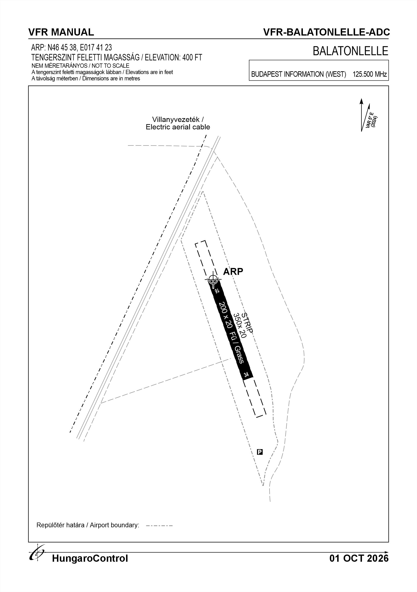
Teljes képernyő
Teljes
képernyő bezárása
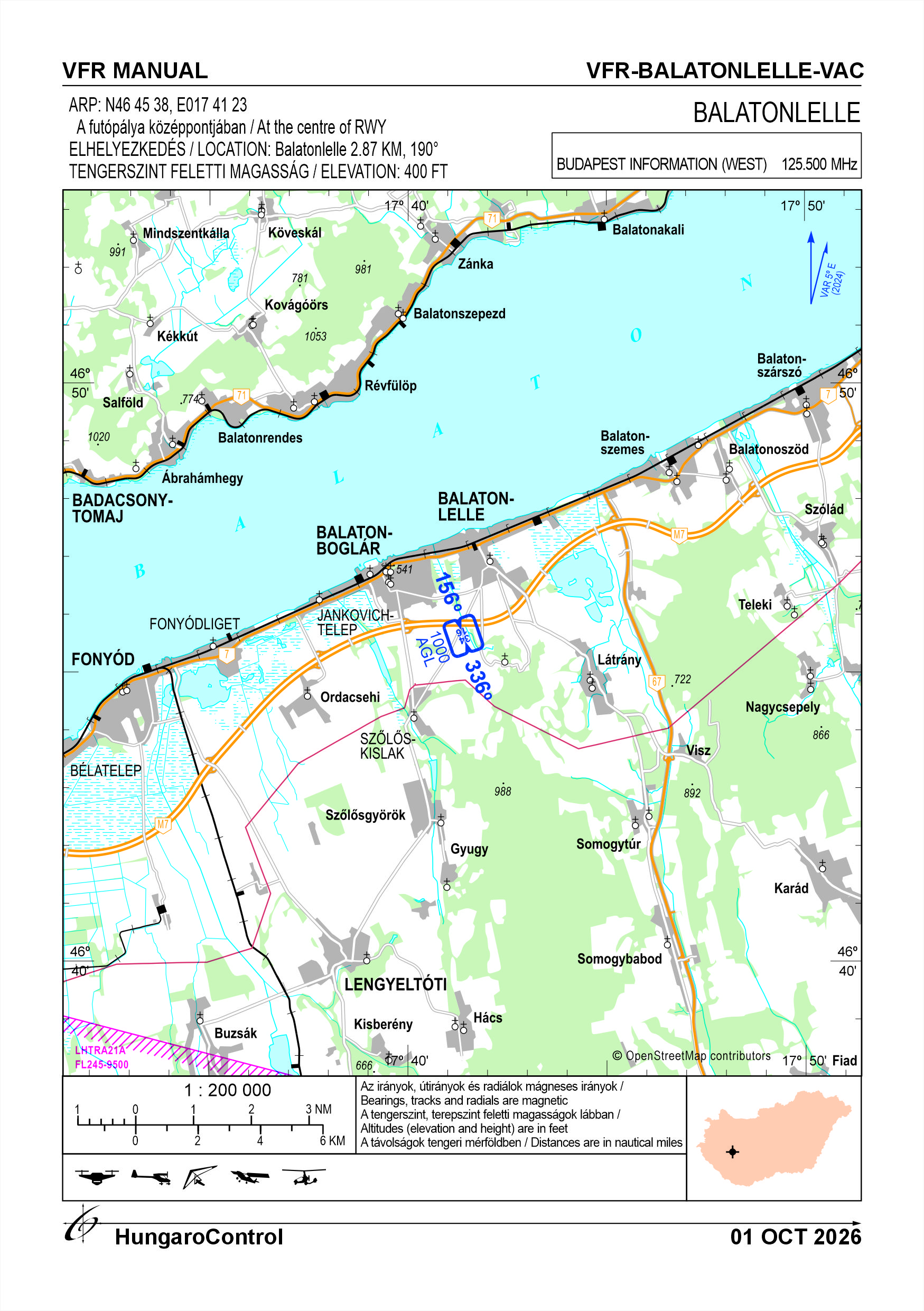
5. Aerodrome geographical and administrative data
ARP data
- Coordinates
- 464538N 0174123E
- Site at aerodrome
- At the center of RWY
Location of aerodrome
- Distance from city (KM)
- Balatonlelle 2.87 KM
- Direction from city
- 190°
- Elevation
- 400 FT
Magnetic variation data
- Degree of magnetic variation ( °)
- 5°24' E
- Annual change ( °)
- +0°06'
- Year of survey
- 2024
Aerodrome operator data
- Name
- Lonkai József
- Address
- 8638 Balatonlelle, Gárdonyi u. 14.
- Phone
- +36-20/326-2423
- Fax
- NIL
- Web
- NIL
- lonkaianiko@gmail.com
Aerodrome data
- Name
- 8638 Balatonlelle, Külterület, Hrsz. 062/112.
- Phone
- +36-20/326-2423 (Lonkai József)
- Fax
- NIL
- Web
- NIL
- lonkaianiko@gmail.com
- AFS
- NIL
- SITA
- NIL
- Others
- NIL
- Type of traffic allowed at the aerodrome
- VFR
- Remarks
- Special airport for civil use, Only PPR
- Name of responsible manager
- Lonkai József
- Hours of service
- Az üzembentartó előzetes engedélye alapján 08:00 LT – tól polgári szürkület végéig. A repülőtér üzemideje áprilistól – szeptember 30-ig tart az időjárás miatt.
6. Air traffic services communication facitlities
|
Service designation
|
Call sign
|
Channel
|
Languages used
|
Hours of operation
|
Remarks
|
|---|---|---|---|---|---|
| NIL | NIL | NIL | NIL | NIL | NIL |
7. Operation hours
- AD Administration
- With the prior permission of the operator from 08:00 LT until the end of civil twilight. Airport operating hours are from April to 30 September due to weather conditions.
- Customs and immigration
- NIL
- Health and sanitation
- NIL
- AIS Briefing Office
- NIL
- ATS Reporting Office (ARO)
- NIL
- MET Briefing Office
- NIL
- ATS
- NIL
- Fuelling
- Only filling your own fuel is possible!
- Handling
- NIL
- Security
- NIL
- De-icing
- NIL
- Remarks
- NIL
8. Available handling services and facilities
- Cargo-handling facilities
- NIL
- Fuel types
- NIL
- Oil types
- NIL
- Fuelling facilities and capacity
- NIL
- De-icing facilities
- NIL
- Hangar space for visiting aircraft
- NIL
- Repair facilities for visiting aircraft
- NIL
- Remarks
- The airport provides the following facilities for the loading of fuel supplied by the pilot of the aircraft: 2 pcs of 20 l plate fuel cans 1 pc of 5 l plate funnel with suede filter 1 pc of ladder for fuel filling
9. Passenger facilities
- Hotels
- NIL
- Restaurants
- NIL
- Transportation
- NIL
- Medical facilities
- NIL
- Bank and Post Office
- NIL
- Tourist Office
- NIL
- Remarks
- NIL
10. Available rescue and fire fighting services
- Aerodrome catogory for fire fighting
- Category 1 as defined in Annex 3 to Government Decree 85/2024 (IV.17).
- Available rescue and fire fighting services
- NIL
- Rescue and fire fighting equipment
-
Equipment required by point 2.9 of Annex 3 to Government Decree 85/2024 (IV. 17);
Available extinguishing capacity:43A 233B C MaxFire Green 6 kg ABC powder extinguisher 4 x 12 OE (4 pcs)
- Capability for removal of disabled aircraft
- 1 passenger vehicle with towing hook
- Remarks
- The 4 pcs. 43A 233B C fire extinguishers will be mounted on the trailer of the rescue vehicle with towing hook.
11. Clearing
- Types of clearing equipment
- NIL
- Clearance priorities
- NIL
- Remarks
- NIL
12. Aprons
|
Designation
|
Surface
|
Strength
|
Remarks
|
Designator
|
|---|---|---|---|---|
| NIL | NIL | NIL | NIL | NIL |
13. Taxiways
|
Designation
|
Surface
|
Strength
|
Width (M)
|
Remarks
|
Designatior
|
|---|---|---|---|---|---|
| NIL | NIL | NIL | NIL | NIL | NIL |
14. Checkpoints
Altimeter checkpoints and locations data
- Coordinates
- NIL
- Technical data
- NIL
- VOR checkpoints
- NIL
- INS checkpoints
- NIL
- Remarks
- NIL
15. Surface movement guidance and control system and markings
- Use of aircraft stand ID signs, TWY guide lines and visual docking/parking guidance system of aircraft stands
- NIL
- RWY and TWY markings and lighting
-
RWY threshold signs, edge signs
Lighting systems: NIL
- Stop bars
- NIL
- Remarks
- NIL
16. Runways (RWY)
|
RWY designator
|
True bearing
|
Magnetic bearing
|
Length (M)
|
Width (M)
|
Strength
|
Surface
|
Remarks
|
|---|---|---|---|---|---|---|---|
| 16 | 161° | 156° | 200 | 20 | 5.5 t (2 t) | Grass | Information on runway conditions is available on request from the airport manager |
| 34 | 341° | 336° | 200 | 20 | 5.5 t (2 t) | Grass | Information on runway conditions is available on request from the airport manager |
17. Aerodrome obstacles
|
RWY designator
|
Obstacle type
|
Elevation
|
Height
|
Coordinates
|
Remarks
|
|---|---|---|---|---|---|
| NIL | GNSSnet tower | 147 M | 70.92 M | 464010.03N 0174056.58E |
Tower height: 66.68 m Lightning conductor height: 4.24 m Direction: ARP: 213.12° Distance: 1,020 m |
18. Stopways (SWY)
|
RWY designator
|
Length (M)
|
Width (M)
|
Strength
|
Surface
|
Slope (%)
|
Remarks
|
|---|---|---|---|---|---|---|
| 16 | NIL | NIL | NIL | NIL | NIL | NIL |
| 34 | NIL | NIL | NIL | NIL | NIL | NIL |
19. Clearways (CWY)
|
RWY designator
|
Length (M)
|
Width (M)
|
Slope (%)
|
Remarks
|
|---|---|---|---|---|
| 16 | NIL | NIL | NIL | NIL |
| 34 | NIL | NIL | NIL | NIL |
20. STRIP
|
RWY designator
|
Length (M)
|
Width (M)
|
Remarks
|
|---|---|---|---|
| 16 | 350 | 20 | Grass |
| 34 | 350 | 20 | Grass |
21. RESA
|
RWY designator
|
Length (M)
|
Width (M)
|
Surface
|
Obstacle free zone (OFZ)
|
Remarks
|
|---|---|---|---|---|---|
| 16 | NIL | NIL | NIL | NIL | NIL |
| 34 | NIL | NIL | NIL | NIL | NIL |
22. Declared distances
|
RWY designator
|
TORA (M)
|
TODA (M)
|
ASDA (M)
|
LDA (M)
|
Remarks
|
|---|---|---|---|---|---|
| 16 | 200 | 200 | 200 | 200 | NIL |
| 34 | 200 | 200 | 200 | 200 | NIL |
23. Approach lighting
|
RWY designator
|
Type
|
Length (M)
|
Intensity
|
Remarks
|
|---|---|---|---|---|
| 16 | NIL | NIL | NIL | NIL |
| 34 | NIL | NIL | NIL | NIL |
24. Threshold lighting
|
RWY designator
|
Colour
|
Wing bar lights
|
Remarks
|
|---|---|---|---|
| 16 | NIL | NIL | NIL |
| 34 | NIL | NIL | NIL |
25. Visual approach slope indicator system lighting
|
RWY designator
|
Type
|
Data
|
Remarks
|
|---|---|---|---|
| 16 | NIL | NIL | NIL |
| 34 | NIL | NIL | NIL |
26. Touchdone zone lighting
|
RWY designator
|
Length of lighting (M)
|
Remarks
|
|---|---|---|
| 16 | NIL | NIL |
| 34 | NIL | NIL |
27. Runway centreline lighting
|
RWY designator
|
Length (M)
|
Spacing (M)
|
Colour
|
Intensity
|
Remarks
|
|---|---|---|---|---|---|
| 16 | NIL | NIL | NIL | NIL | NIL |
| 34 | NIL | NIL | NIL | NIL | NIL |
28. Runway edgeline lighting
|
RWY designator
|
Length (M)
|
Spacing (M)
|
Colour
|
Intensity
|
Remarks
|
|---|---|---|---|---|---|
| 16 | NIL | NIL | NIL | NIL | NIL |
| 34 | NIL | NIL | NIL | NIL | NIL |
29. Runway end lighting
|
RWY designator
|
Colour
|
Remarks
|
|---|---|---|
| 16 | NIL | NIL |
| 34 | NIL | NIL |
30. Runway wing bars lighting
|
RWY designator
|
Colour
|
Remarks
|
|---|---|---|
| 16 | NIL | NIL |
| 34 | NIL | NIL |
31. Stopway lighting
|
RWY designator
|
Length of lighting (M)
|
Colour
|
Remarks
|
|---|---|---|---|
| 16 | NIL | NIL | NIL |
| 34 | NIL | NIL | NIL |
32. Other lighting, secondary power supply
- ABN/IBN location, charasteristics and hours of operation
- NIL
- LDI location and lighting
-
Approach beacon; 46°45’36.11”N 017°41’22.93”E
Lighting: NIL
- Anemometer location and lighting
- NIL
- 4Centre line lighting
- NIL
- TWY edge line lighting
- NIL
- Secondary power supply
- NIL
- Switch-over time
- NIL
- Remarks
- NIL
33. Helicopter landing area
- Coordinates TLOF or THR of FATO
- NIL
- TLOF and/or FATO elevation
- NIL
- TLOF and FATO area marking
- NIL
- TLOF and FATO area dimensions (M)
- NIL
- TLOF and FATO area surface
- NIL
- TLOF and FATO area strength
- NIL
- True BRG of FATO
- NIL
- MAG BRG of FATO
- NIL
- Declared distances available
- NIL
- APP and FATO lighting
- NIL
- Remarks
- NIL
34. Meteorological information provider
- Associated MET Office
- HungaroMet Magyar Meteorológiai Szolgáltató Nonprofit Zrt. (HungaroMet Zrt.), Unit of Aviation Meteorology
- Hours of service
- H24
- Office responsible for TAF preparation
- HungaroMet Magyar Meteorológiai Szolgáltató Nonprofit Zrt. (HungaroMet Zrt.), Unit of Aviation Meteorology
- Periods of validity
- NIL
- Interval of issuance
- NIL
- Type of landing forecast
- NIL
- Landing forecast interval of issuance
- NIL
- Briefing/consultation provided
- Written briefing: https://aviation.met.hu;Consultation via phone: +36-90/603-424;Consultation via e-mail: rvo@met.hu;
- Flight documentation
- Charts, abbreviated plain language text
- Language(s) used
- HU, EN
- Charts and other information available for briefing or consultation
- Charts, aerodrome reports and forecasts in EUR region, area forecasts, MET. observations and warnings in Budapest FIR
- Supplementary equipment available for providing information
- Self-briefing via aviation.met.hu
- ATS Units provided with information
- Budapest FIC (on request)
- Remarks
- NIL
35. Air traffic service airspace
- Designation
- NIL
- Lateral limits
- NIL
- Vertical limits (FT)
- NIL
- Airspace classification
- NIL
- ATS unit call sign
- NIL
- Languages used
- NIL
- Transition altitude (FT)
- NIL
- Remarks
- NIL
37. Local aerodrome regulations
Balatonlelle Airport is a special-purpose civil airport and is not open to the general public.
The airport’s operating hours are from 08:00 local time until the end of civil twilight, subject to prior agreement with the owner.
Only daytime VFR flights with microlight aircraft are permitted at the aerodrome.
There are no refuelling facilities at the aerodrome; however, pilots of aircraft using the aerodrome may refuel with their own fuel.
Subject to the decision of the airport operator, the airport may be used by aircraft with a maximum take-off mass (MTOM) of up to 600 kilograms, provided that their flight manual specifies a take-off or landing distance shorter than the available runway length.
When conducting local flights, and during every take-off or landing, report the aircraft’s position on frequency 135.710 MHz. The call sign is: ‘Balatonlelle – Airport’.
Procedures relating to local flights:
Taking wind directions into account, flights may be conducted at the aerodrome using the following runways:
- Left and right training circuits when using runway 34 for take-off
- Left and right training circuits when using runway 16 for take-off
Restrictions relating to the use of the airport and aircraft:
Except in an emergency, the airport may only be used for take-off and landing by aircraft for which the reference runway length specified in the aircraft’s flight operations manual – that is, the minimum runway length required for take-off – corresponds to the available runway length, and which have obtained prior authorisation from the airport operator.
Further information can be found in the current Airport Rules.
The airport’s operating hours are from 08:00 local time until the end of civil twilight, subject to prior agreement with the owner.
Only daytime VFR flights with microlight aircraft are permitted at the aerodrome.
There are no refuelling facilities at the aerodrome; however, pilots of aircraft using the aerodrome may refuel with their own fuel.
Subject to the decision of the airport operator, the airport may be used by aircraft with a maximum take-off mass (MTOM) of up to 600 kilograms, provided that their flight manual specifies a take-off or landing distance shorter than the available runway length.
When conducting local flights, and during every take-off or landing, report the aircraft’s position on frequency 135.710 MHz. The call sign is: ‘Balatonlelle – Airport’.
Procedures relating to local flights:
Taking wind directions into account, flights may be conducted at the aerodrome using the following runways:
- Left and right training circuits when using runway 34 for take-off
- Left and right training circuits when using runway 16 for take-off
Restrictions relating to the use of the airport and aircraft:
Except in an emergency, the airport may only be used for take-off and landing by aircraft for which the reference runway length specified in the aircraft’s flight operations manual – that is, the minimum runway length required for take-off – corresponds to the available runway length, and which have obtained prior authorisation from the airport operator.
Further information can be found in the current Airport Rules.
Activities at the airport (Yes / No)
- Unmanned aerial vehicle (D)
- Yes
- Ballon (B)
- No
- Ultralight (U)
- Yes
- Hang glider (N)
- Yes
- Short take-off and landing (R)
- Yes
- Landplane (L)
- No
- Paraglider (P)
- No
- Glider (G)
- No
- Amphibian (A)
- No
- Helicopter (H)
- No
- Gyrocopter (G)
- Yes
- Tilt-wing aircraft (T)
- No
- Other (O)
- No
38. Noise abatement procedures
In order to reduce the noise impact of the Balatonlelle Airport on the surrounding communities, the following local regulations apply. - Engine checks of UL aircraft requiring a power setting higher than the base throttle can only be performed on the runway; - The traffic circle is 300 m AGL. Deviations from the prescribed traffic circle are only permitted for reasons of aviation safety; - It is prohibited for arriving and departing motorised aircraft to fly above a populated area below 300 m AGL;
39. Aerodrome charges
No fee
40. Additional information
For more information, see the Airport Rules.
41. Aerodrome obstacles
- No obstacle text
- NIL
- RWY designator
- NIL
- Obstacle type
- NIL
- Elevation
- NIL
- Height
- NIL
- Coordinates
- NIL
- Remarks
- NIL