- Tapolca Airport
Last updated: 2025.08.07.
1. Aerodrome identification
- Aerodrome location indicator
- -
- Aerodrome name
- Tapolca Airport
- Aerodrome place name
- Tapolca
2. Contact
- Address
- 8300 Tapolca, hrsz. 0110/2
- Phone
- +36-30/444-7343
- tapolcarepules@gmail.com
3. Gallery
Teljes képernyő
Teljes
képernyő bezárása

Teljes képernyő
Teljes
képernyő bezárása

Teljes képernyő
Teljes
képernyő bezárása
Teljes képernyő
Teljes
képernyő bezárása
5. Aerodrome geographical and administrative data
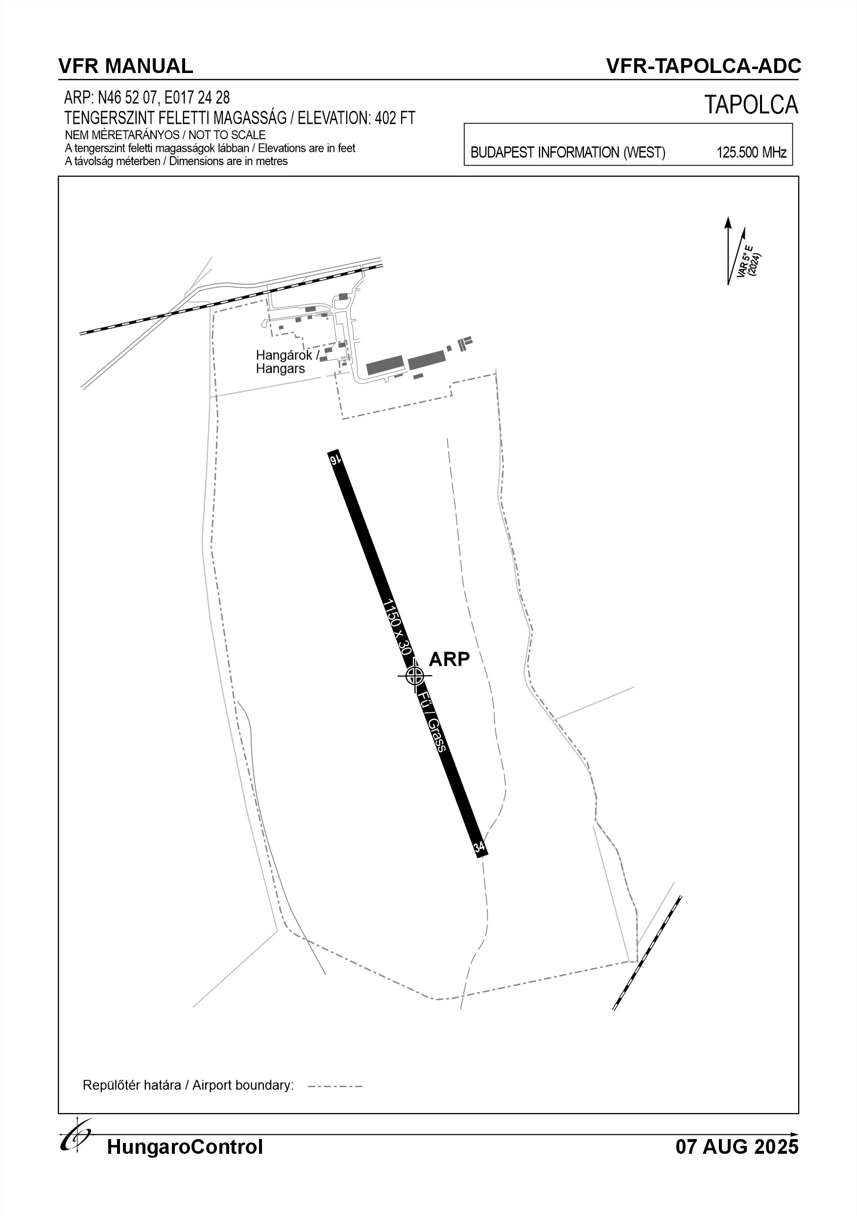
ARP data
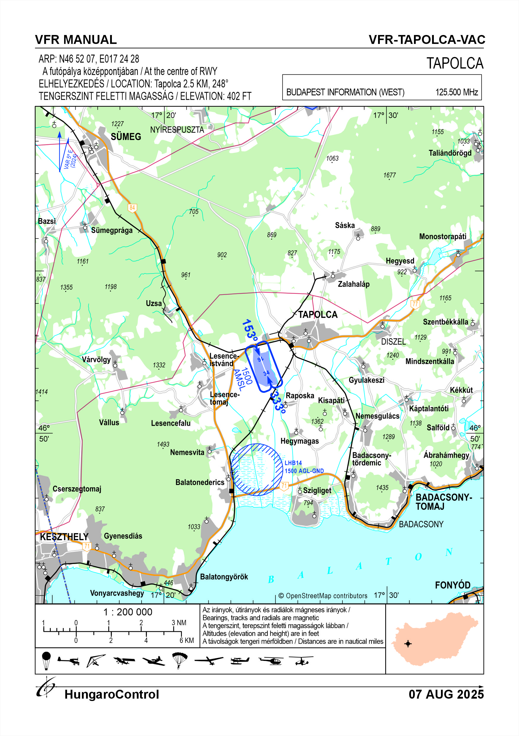
- Coordinates
- 465207N 0172428E
- Site at aerodrome
- At the centre of the RWY
Location of aerodrome
- Distance from city (KM)
- Tapolca 2.5 KM
- Direction from city
- 248°
- Elevation
- 402 FT
Magnetic variation data
- Degree of magnetic variation ( °)
- 5°19' E
- Annual change ( °)
- +0°09'
- Year of survey
- 2024
Aerodrome operator data
- Name
- Tapolcai Repülő Egyesület
- Address
- 8300 Tapolca, hrsz. 4507/2
- Phone
- +36-30/444-7343
- Fax
- NIL
- tapolcarepules@gmail.com
Aerodrome data
- Name
- 8300 Tapolca, hrsz. 0110/2
- Phone
- +36-30/444-7343 (Mátrai György Tibor)
- Fax
- NIL
- Web
- NIL
- tapolcarepules@gmail.com
- AFS
- NIL
- SITA
- NIL
- Others
- NIL
- Type of traffic allowed at the aerodrome
- VFR
- Remarks
- Special airport for civil use, Only PPR
6. Air traffic services communication facitlities
|
Service designation
|
Call sign
|
Channel
|
Languages used
|
Hours of operation
|
Remarks
|
|---|---|---|---|---|---|
| Tapolca Rádió | Tapolca Rádió | 136,09166 MHz | HU | during the execution of flights | NIL |
7. Operation hours
- AD Administration
- All year round, from sunrise to sunset, only in conditions suitable for VFR flights, with the prior permission of the airport operator
- Customs and immigration
- NIL
- Health and sanitation
- NIL
- AIS Briefing Office
- NIL
- ATS Reporting Office (ARO)
- NIL
- MET Briefing Office
- NIL
- ATS
- NIL
- Fuelling
- NIL
- Handling
- NIL
- Security
- Area monitored by camera
- De-icing
- NIL
- Remarks
- NIL
8. Available handling services and facilities
- Cargo-handling facilities
- NIL
- Fuel types
- NIL
- Oil types
- NIL
- Fuelling facilities and capacity
- NIL
- De-icing facilities
- NIL
- Hangar space for visiting aircraft
- NIL
- Repair facilities for visiting aircraft
- NIL
- Remarks
- NIL
9. Passenger facilities
- Hotels
- In the city of Tapolca
- Restaurants
- In the city of Tapolca
- Transportation
- Taxi
- Medical facilities
- In the city of Tapolca
- Bank and Post Office
- In the city of Tapolca
- Tourist Office
- In the city of Tapolca
- Remarks
- NIL
10. Available rescue and fire fighting services
- Aerodrome catogory for fire fighting
- Category 1 as defined in Annex 3 to Government Decree 85/2024 (IV.17).
- Available rescue and fire fighting services
- 1 person with a higher level fire safety qualification
- Rescue and fire fighting equipment
- Fire extinguishers and equipment in category 1 of Annex 3 of Government Decree 85/2024 (IV.17).
- Capability for removal of disabled aircraft
- NIL
- Remarks
- NIL
11. Clearing
- Types of clearing equipment
- NIL
- Clearance priorities
- NIL
- Remarks
- NIL
12. Aprons
|
Designation
|
Surface
|
Strength
|
Remarks
|
|---|---|---|---|
| NIL | NIL | NIL | NIL |
13. Taxiways
|
Designation
|
Surface
|
Strength
|
Width (M)
|
Remarks
|
|---|---|---|---|---|
| TWY-A | Grass | 12 kg/cm2 | 20 | NIL |
14. Checkpoints
Altimeter checkpoints and locations data
- Coordinates
- THR16
- Technical data
- 402 FT AMSL (122 M)
- VOR checkpoints
- NIL
- INS checkpoints
- NIL
- Remarks
- NIL
15. Surface movement guidance and control system and markings
- Use of aircraft stand ID signs, TWY guide lines and visual docking/parking guidance system of aircraft stands
- NIL
- RWY and TWY markings and lighting
- RWY threshold signs, edge signs
- Stop bars
- NIL
- Remarks
- NIL
16. Runways (RWY)
|
RWY designator
|
True bearing
|
Magnetic bearing
|
Length (M)
|
Width (M)
|
Strength
|
Surface
|
Remarks
|
|---|---|---|---|---|---|---|---|
| 16 | 163° | 158° | 1150 | 30 | 10 t (5.7 t) | Grass | The airport can only be used by helicopters under 5.7 t MTOW, except by the air force |
| 34 | 343° | 338° | 1150 | 30 | 10 t (5.7 t) | Grass | The airport can only be used by helicopters under 5.7 t MTOW, except by the air force |
17. Aerodrome obstacles
18. Stopways (SWY)
|
RWY designator
|
Length (M)
|
Width (M)
|
Strength
|
Surface
|
Slope (%)
|
Remarks
|
|---|---|---|---|---|---|---|
| 16 | NIL | NIL | NIL | NIL | NIL | NIL |
| 34 | NIL | NIL | NIL | NIL | NIL | NIL |
19. Clearways (CWY)
|
RWY designator
|
Length (M)
|
Width (M)
|
Slope (%)
|
Remarks
|
|---|---|---|---|---|
| 16 | NIL | NIL | NIL | NIL |
| 34 | NIL | NIL | NIL | NIL |
20. STRIP
|
RWY designator
|
Length (M)
|
Width (M)
|
Remarks
|
|---|---|---|---|
| 16 | 1210 | 120 | Grass |
| 34 | 1210 | 120 | Grass |
21. RESA
|
RWY designator
|
Length (M)
|
Width (M)
|
Surface
|
Obstacle free zone (OFZ)
|
Remarks
|
|---|---|---|---|---|---|
| 16 | NIL | NIL | NIL | NIL | NIL |
| 34 | NIL | NIL | NIL | NIL | NIL |
22. Declared distances
|
RWY designator
|
TORA (M)
|
TODA (M)
|
ASDA (M)
|
LDA (M)
|
Remarks
|
|---|---|---|---|---|---|
| 16 | 1150 | 1150 | 1150 | 1150 | NIL |
| 34 | 1150 | 1150 | 1150 | 1150 | NIL |
23. Approach lighting
|
RWY designator
|
Type
|
Length (M)
|
Intensity
|
Remarks
|
|---|---|---|---|---|
| 16 | NIL | NIL | NIL | NIL |
| 34 | NIL | NIL | NIL | NIL |
24. Threshold lighting
|
RWY designator
|
Colour
|
Wing bar lights
|
Remarks
|
|---|---|---|---|
| 16 | NIL | NIL | NIL |
| 34 | NIL | NIL | NIL |
25. Visual approach slope indicator system lighting
|
RWY designator
|
Type
|
Data
|
Remarks
|
|---|---|---|---|
| 16 | NIL | NIL | NIL |
| 34 | NIL | NIL | NIL |
26. Touchdone zone lighting
|
RWY designator
|
Length of lighting (M)
|
Remarks
|
|---|---|---|
| 16 | NIL | NIL |
| 34 | NIL | NIL |
27. Runway centreline lighting
|
RWY designator
|
Length (M)
|
Spacing (M)
|
Colour
|
Intensity
|
Remarks
|
|---|---|---|---|---|---|
| 16 | NIL | NIL | NIL | NIL | NIL |
| 34 | NIL | NIL | NIL | NIL | NIL |
28. Runway edgeline lighting
|
RWY designator
|
Length (M)
|
Spacing (M)
|
Colour
|
Intensity
|
Remarks
|
|---|---|---|---|---|---|
| 16 | NIL | NIL | NIL | NIL | NIL |
| 34 | NIL | NIL | NIL | NIL | NIL |
29. Runway end lighting
|
RWY designator
|
Colour
|
Remarks
|
|---|---|---|
| 16 | NIL | NIL |
| 34 | NIL | NIL |
30. Runway wing bars lighting
|
RWY designator
|
Colour
|
Remarks
|
|---|---|---|
| 16 | NIL | NIL |
| 34 | NIL | NIL |
31. Stopway lighting
|
RWY designator
|
Length of lighting (M)
|
Colour
|
Remarks
|
|---|---|---|---|
| 16 | NIL | NIL | NIL |
| 34 | NIL | NIL | NIL |
32. Other lighting, secondary power supply
- ABN/IBN location, charasteristics and hours of operation
- NIL
- LDI location and lighting
- NIL
- Anemometer location and lighting
- On top of the hangar without lighting
- 4Centre line lighting
- NIL
- TWY edge line lighting
- NIL
- Secondary power supply
- NIL
- Switch-over time
- NIL
- Remarks
- NIL
33. Helicopter landing area
- Coordinates TLOF or THR of FATO
- 465225N 0172417E
- TLOF and/or FATO elevation
- 402 FT
- TLOF and FATO area marking
- NIL
- TLOF and FATO area dimensions (M)
- 50 x 50
- TLOF and FATO area surface
- NIL
- TLOF and FATO area strength
- NIL
- True BRG of FATO
- NIL
- MAG BRG of FATO
- NIL
- Declared distances available
- NIL
- APP and FATO lighting
- NIL
- Remarks
- At THR 16
34. Meteorological information provider
- Associated MET Office
- HungaroMet Magyar Meteorológiai Szolgáltató Nonprofit Zrt. (HungaroMet Zrt.), Unit of Aviation Meteorology
- Hours of service
- H24
- Office responsible for TAF preparation
- HungaroMet Magyar Meteorológiai Szolgáltató Nonprofit Zrt. (HungaroMet Zrt.), Unit of Aviation Meteorology
- Periods of validity
- NIL
- Interval of issuance
- NIL
- Type of landing forecast
- NIL
- Landing forecast interval of issuance
- NIL
- Briefing/consultation provided
- Written briefing: https://aviation.met.hu;Consultation via phone: +36-90/603-424;Consultation via e-mail: rvo@met.hu;
- Flight documentation
- Charts, abbreviated plain language text
- Language(s) used
- HU, EN
- Charts and other information available for briefing or consultation
- Charts, aerodrome reports and forecasts in EUR region, area forecasts, MET. observations and warnings in Budapest FIR
- Supplementary equipment available for providing information
- Self-briefing via aviation.met.hu
- ATS Units provided with information
- Budapest FIC (on request)
- Remarks
- NIL
35. Air traffic service airspace
- Designation
- NIL
- Lateral limits
- NIL
- Vertical limits (FT)
- NIL
- Airspace classification
- NIL
- ATS unit call sign
- NIL
- Languages used
- NIL
- Transition altitude (FT)
- NIL
- Remarks
- NIL
37. Local aerodrome regulations
Procedures relating to flights Only aircraft whose commander has requested and received permission from the operator to use the airport by e-mail or telephone may use the airport, except for members of the association. The coordination of daily operations is organised on a day-to-day basis by the responsible manager or his deputy, depending on the weather, traffic and flight operations. Departing and arriving aircraft: Motorised aircraft may take off and land primarily on the designated grass runway (16-34). For glider towing, both the runway and the operational field may be used for take-off and landing. Non-engined aircraft (paragliders, hang gliders, gliders, hot air balloons) may also use the area designated by the flight manager within the operational field for take-off and landing. Powered aircraft should normally use the West traffic circle, unpowered aircraft should normally use the East traffic circle, but may deviate from this based on daily coordination by the flight operations manager (e.g., variable tow airspace, etc.) Traffic circle altitude is 1500 feet AMSL for powered fixed-wing aircraft. For unpowered aircraft and aircraft not equipped with an engine, the traffic circle altitude is progressively reduced from the time of release, as appropriate. When leaving the traffic circle of Tapolca, powered aircraft which have filed a flight plan must report to the NYUGAT SUPPORT radio on 125.500 MHz. Powered aircraft engaged on local flights, if equipped with radio equipment, shall announce their intention to taxi, take-off or land and shall be continuously monitored on the airport frequency throughout their flights. Aircraft not equipped with radio equipment (paragliders, hang gliders, gliders, etc.) must fly in accordance with the SERA rules and ensure separation from other aircraft. Local movement aircraft: In the case of an organised operation: aircraft may move around the airport area, as advised by the flight operations manager, taking into account air and ground traffic, in particular aircraft taking off and landing. In the case of individual flights, local movements may be made without disturbing aircraft traffic and with due regard to it. After landing, taxiing on the runway may be done by turning around to taxi to the apron or hangars. Aircraft may taxi at a maximum speed of 20 km/h. Aircraft may be towed at a maximum speed of 5km/h (walking speed). Aircraft may be parked or parked in a place designated by the flight operator. Aircraft may be powered by the pilot in the manner specified in the operating instructions and at a place designated by the flight manager. The airport is located in a NATURA 2000 area, with increased wildlife presence. For more information, see the Airport Rules.
Activities at the airport (Yes / No)
- Unmanned aerial vehicle (D)
- No
- Ballon (B)
- Yes
- Ultralight (U)
- Yes
- Hang glider (N)
- Yes
- Short take-off and landing (R)
- Yes
- Landplane (L)
- Yes
- Paraglider (P)
- Yes
- Glider (G)
- Yes
- Amphibian (A)
- Yes
- Helicopter (H)
- Yes
- Gyrocopter (G)
- Yes
- Tilt-wing aircraft (T)
- No
- Other (O)
- NIL
38. Noise abatement procedures
The following local regulations apply at the airport in order to reduce noise pollution in the surrounding settlements: Motorised aircraft may taxi on base gas, but at a minimum power level sufficient to move the aircraft. Engine tests on powered aircraft may be conducted with the nose of the aircraft facing buildings. Powered aircraft shall avoid residential areas during the flight of the circuit and during approach and departure, and powered aircraft shall not be permitted to fly over LHB14 environmental airspace below 1500 feet AMSL.
39. Aerodrome charges
NIL
40. Additional information
For more information, see the Airport Rules.