LHVE Veresegyház Airport
Last updated: 2025.11.27.
1. Aerodrome identification
- Aerodrome location indicator
- LHVE
- Aerodrome name
- Veresegyház Airport
- Aerodrome place name
- Veresegyház
2. Contact
- Address
- 2112 Veresegyház, Hrsz.: 046, 059/5, 059/6
- Phone
- +36-30/578-1536
- csepilaci@freemail.hu
3. Gallery
Teljes képernyő
Teljes
képernyő bezárása

Teljes képernyő
Teljes
képernyő bezárása

Teljes képernyő
Teljes
képernyő bezárása

Teljes képernyő
Teljes
képernyő bezárása
Teljes képernyő
Teljes
képernyő bezárása
5. Aerodrome geographical and administrative data
ARP data
- Coordinates
- 473818N 0191523E
- Site at aerodrome
- 139 M from THR 26 on the RWY
Location of aerodrome
- Distance from city (KM)
- Veresegyház 3 KM
- Direction from city
- 234°
- Elevation
- 614 FT
Magnetic variation data
- Degree of magnetic variation ( °)
- 5°47' E
- Annual change ( °)
- +0°09'
- Year of survey
- 2024
Aerodrome operator data
- Name
- East Line Air Team / Csepi László e.v.
- Address
- 2112 Veresegyház, Wesselényi u. 36.
- Phone
- +36-30/578-1536
- Fax
- NIL
- info@setarepulesek.hu
Aerodrome data
- Name
- 2112 Veresegyház, Hrsz.: 046, 059/5, 059/6
- Phone
- +36-30/578-1536 (Csepi László)
- Fax
- NIL
- csepilaci@freemail.hu
- AFS
- NIL
- SITA
- NIL
- Others
- NIL
- Type of traffic allowed at the aerodrome
- VFR
- Remarks
- Special airport for civil use
- Responsible operator's name
- NIL
- Time logged
- NIL
6. Air traffic services communication facitlities
|
Service designation
|
Call sign
|
Channel
|
Languages used
|
Hours of operation
|
Remarks
|
|---|---|---|---|---|---|
| NIL | NIL | NIL | NIL | NIL | NIL |
7. Operation hours
- AD Administration
- Every day of the year, between -30 minutes of maximum sunrise and +45 minutes of maximum sunset, but not longer than dusk and twilight, whichever is more stringent, and in conditions suitable for VFR flight, with runway conditions suitable for the operation of the given aircraft type and with the prior permission of the operator.
- Customs and immigration
- NIL
- Health and sanitation
- NIL
- AIS Briefing Office
- NIL
- ATS Reporting Office (ARO)
- NIL
- MET Briefing Office
- NIL
- ATS
- NIL
- Fuelling
- NIL
- Handling
- NIL
- Security
- On request
- De-icing
- NIL
- Remarks
- NIL
8. Available handling services and facilities
- Cargo-handling facilities
- NIL
- Fuel types
- NIL
- Oil types
- NIL
- Fuelling facilities and capacity
- Storage under 1000 liters
- De-icing facilities
- NIL
- Hangar space for visiting aircraft
- Outdoor storage is possible only by prior arrangement.
- Repair facilities for visiting aircraft
- NIL
- Remarks
- NIL
9. Passenger facilities
- Hotels
- NIL
- Restaurants
- NIL
- Transportation
- Railway, road
- Medical facilities
- First aid at the airport, National Ambulance Service
- Bank and Post Office
- NIL
- Tourist Office
- www.veresegyhaz.hu
- Remarks
- NIL
10. Available rescue and fire fighting services
- Aerodrome catogory for fire fighting
- Category 1 and 2 as defined in Annex 3 to Government Decree 85/2024 (IV.17). Economic activity carried out by aircraft can be carried out with aircraft with an MTOW between 600 and 2730 kg, up to a maximum of 60 operations per month.
- Available rescue and fire fighting services
- They provide services depending on the activities permitted by the operator, in the number of personnel required for the activity. During economic activities carried out with an aircraft, the minimum number of personnel is 1 person, who must have at least basic firefighting training or a fire protection examination.
- Rescue and fire fighting equipment
- Extinguishing devices and equipment belonging to category 2 as described in Annex 3 of Government Decree 85/2024 (IV.17). Minimum 1 motor vehicle that can move effectively on the airport and its surroundings. Extinguishing devices with an extinguishing capacity of 100 extinguishing units as specified in Decree 54/2014 of the Ministry of the Interior, which are suitable for extinguishing at least class A, B and C fires. (Handheld powder fire extinguishers)
- Capability for removal of disabled aircraft
- Manual movement, car towing
- Remarks
- NIL
11. Clearing
- Types of clearing equipment
- NIL
- Clearance priorities
- NIL
- Remarks
- In snowy conditions, if the thickness of the snow layer prevents the safe operation of the aircraft, the airport will not operate.
12. Aprons
|
Designation
|
Surface
|
Strength
|
Remarks
|
Designator
|
|---|---|---|---|---|
| APRON | Grass | 10 t (5.7 t) | Outside the runway strip | NIL |
13. Taxiways
|
Designation
|
Surface
|
Strength
|
Width (M)
|
Remarks
|
Designatior
|
|---|---|---|---|---|---|
| NIL | NIL | NIL | NIL | NIL | NIL |
14. Checkpoints
Altimeter checkpoints and locations data
- Coordinates
- NIL
- Technical data
- NIL
- VOR checkpoints
- NIL
- INS checkpoints
- NIL
- Remarks
- NIL
15. Surface movement guidance and control system and markings
- Use of aircraft stand ID signs, TWY guide lines and visual docking/parking guidance system of aircraft stands
- NIL
- RWY and TWY markings and lighting
- RWY threshold signs, edge signs
- Stop bars
- NIL
- Remarks
- NIL
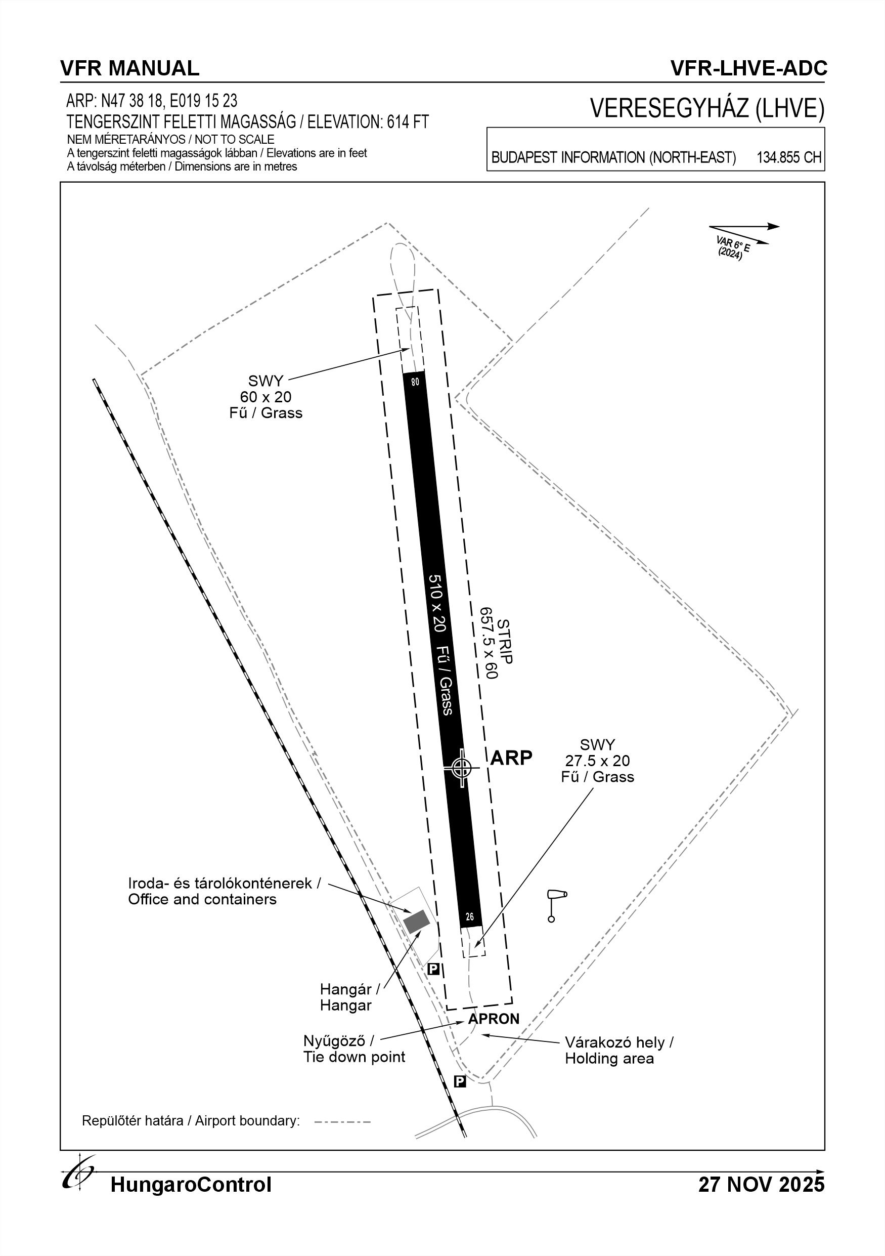
16. Runways (RWY)
|
RWY designator
|
True bearing
|
Magnetic bearing
|
Length (M)
|
Width (M)
|
Strength
|
Surface
|
Remarks
|
|---|---|---|---|---|---|---|---|
| 08 | 084° | 078° | 510 | 20 | 10 t (5.7 t) | Grass | Depending on the moisture of the surface, the operator may prohibit the movement of certain aircraft; in the event of significant wetness, the operator will close the airport. |
| 26 | 264° | 258° | 510 | 20 | 10 t (5.7 t) | Grass | Depending on the moisture of the surface, the operator may prohibit the movement of certain aircraft; in the event of significant wetness, the operator will close the airport. |
17. Aerodrome obstacles
|
RWY designator
|
Obstacle type
|
Elevation
|
Height
|
Coordinates
|
Remarks
|
|---|---|---|---|---|---|
| 26 | Tree line | 623 FT | 13 FT | 473818N 0191536E | 84°/ 100 M from the THR 26 |
| 08 | Tree line out of runway srtrip | 633 FT | 33 FT | 473817N 0191457E | 264°/ 150 M from the THR 08 |
| 08 | Tree out of runway srtrip | 633 FT | 33 FT | 473819N 0191508E | 030°/ 70 M from the THR 08 |
18. Stopways (SWY)
|
RWY designator
|
Length (M)
|
Width (M)
|
Strength
|
Surface
|
Slope (%)
|
Remarks
|
|---|---|---|---|---|---|---|
| 08 | 27.5 | 20 | 13.8 kg/cm2 | Grass | NIL | NIL |
| 26 | 60 | 20 | 13.8 kg/cm2 | Grass | NIL | NIL |
19. Clearways (CWY)
|
RWY designator
|
Length (M)
|
Width (M)
|
Slope (%)
|
Remarks
|
|---|---|---|---|---|
| 08 | NIL | NIL | NIL | NIL |
| 26 | NIL | NIL | NIL | NIL |
20. STRIP
|
RWY designator
|
Length (M)
|
Width (M)
|
Remarks
|
|---|---|---|---|
| 08 | 657.5 | 60 | Surface: Grass |
| 26 | 657.5 | 60 | Surface: Grass |
21. RESA
|
RWY designator
|
Length (M)
|
Width (M)
|
Surface
|
Obstacle free zone (OFZ)
|
Remarks
|
|---|---|---|---|---|---|
| 08 | NIL | NIL | NIL | NIL | NIL |
| 26 | NIL | NIL | NIL | NIL | NIL |
22. Declared distances
|
RWY designator
|
TORA (M)
|
TODA (M)
|
ASDA (M)
|
LDA (M)
|
Remarks
|
|---|---|---|---|---|---|
| 08 | 510 | 510 | 537.5 | 510 | NIL |
| 26 | 510 | 510 | 570 | 510 | NIL |
23. Approach lighting
|
RWY designator
|
Type
|
Length (M)
|
Intensity
|
Remarks
|
|---|---|---|---|---|
| 08 | NIL | NIL | NIL | NIL |
| 26 | NIL | NIL | NIL | NIL |
24. Threshold lighting
|
RWY designator
|
Colour
|
Wing bar lights
|
Remarks
|
|---|---|---|---|
| 08 | NIL | NIL | NIL |
| 26 | NIL | NIL | NIL |
25. Visual approach slope indicator system lighting
|
RWY designator
|
Type
|
Data
|
Remarks
|
|---|---|---|---|
| 08 | NIL | NIL | NIL |
| 26 | NIL | NIL | NIL |
26. Touchdone zone lighting
|
RWY designator
|
Length of lighting (M)
|
Remarks
|
|---|---|---|
| 08 | NIL | NIL |
| 26 | NIL | NIL |
27. Runway centreline lighting
|
RWY designator
|
Length (M)
|
Spacing (M)
|
Colour
|
Intensity
|
Remarks
|
|---|---|---|---|---|---|
| 08 | NIL | NIL | NIL | NIL | NIL |
| 26 | NIL | NIL | NIL | NIL | NIL |
28. Runway edgeline lighting
|
RWY designator
|
Length (M)
|
Spacing (M)
|
Colour
|
Intensity
|
Remarks
|
|---|---|---|---|---|---|
| 08 | NIL | NIL | NIL | NIL | NIL |
| 26 | NIL | NIL | NIL | NIL | NIL |
29. Runway end lighting
|
RWY designator
|
Colour
|
Remarks
|
|---|---|---|
| 08 | NIL | NIL |
| 26 | NIL | NIL |
30. Runway wing bars lighting
|
RWY designator
|
Colour
|
Remarks
|
|---|---|---|
| 08 | NIL | NIL |
| 26 | NIL | NIL |
31. Stopway lighting
|
RWY designator
|
Length of lighting (M)
|
Colour
|
Remarks
|
|---|---|---|---|
| 08 | NIL | NIL | NIL |
| 26 | NIL | NIL | NIL |
32. Other lighting, secondary power supply
- ABN/IBN location, charasteristics and hours of operation
- NIL
- LDI location and lighting
- NIL
- Anemometer location and lighting
- NIL
- 4Centre line lighting
- NIL
- TWY edge line lighting
- NIL
- Secondary power supply
- NIL
- Switch-over time
- NIL
- Remarks
- NIL
33. Helicopter landing area
- Coordinates TLOF or THR of FATO
- NIL
- TLOF and/or FATO elevation
- NIL
- TLOF and FATO area marking
- NIL
- TLOF and FATO area dimensions (M)
- NIL
- TLOF and FATO area surface
- NIL
- TLOF and FATO area strength
- NIL
- True BRG of FATO
- NIL
- MAG BRG of FATO
- NIL
- Declared distances available
- NIL
- APP and FATO lighting
- NIL
- Remarks
- NIL
34. Meteorological information provider
- Associated MET Office
- HungaroMet Magyar Meteorológiai Szolgáltató Nonprofit Zrt. (HungaroMet Zrt.), Unit of Aviation Meteorology
- Hours of service
- H24
- Office responsible for TAF preparation
- HungaroMet Magyar Meteorológiai Szolgáltató Nonprofit Zrt. (HungaroMet Zrt.), Unit of Aviation Meteorology
- Periods of validity
- NIL
- Interval of issuance
- NIL
- Type of landing forecast
- NIL
- Landing forecast interval of issuance
- NIL
- Briefing/consultation provided
- Written briefing: https://aviation.met.hu;Consultation via phone: +36-90/603-424;Consultation via e-mail: rvo@met.hu;
- Flight documentation
- Charts, abbreviated plain language text
- Language(s) used
- HU, EN
- Charts and other information available for briefing or consultation
- Charts, aerodrome reports and forecasts in EUR region, area forecasts, MET. observations and warnings in Budapest FIR
- Supplementary equipment available for providing information
- Self-briefing via aviation.met.hu
- ATS Units provided with information
- Budapest FIC (on request)
- Remarks
- NIL
35. Air traffic service airspace
- Designation
- NIL
- Lateral limits
- NIL
- Vertical limits (FT)
- NIL
- Airspace classification
- NIL
- ATS unit call sign
- NIL
- Languages used
- NIL
- Transition altitude (FT)
- NIL
- Remarks
- NIL
37. Local aerodrome regulations
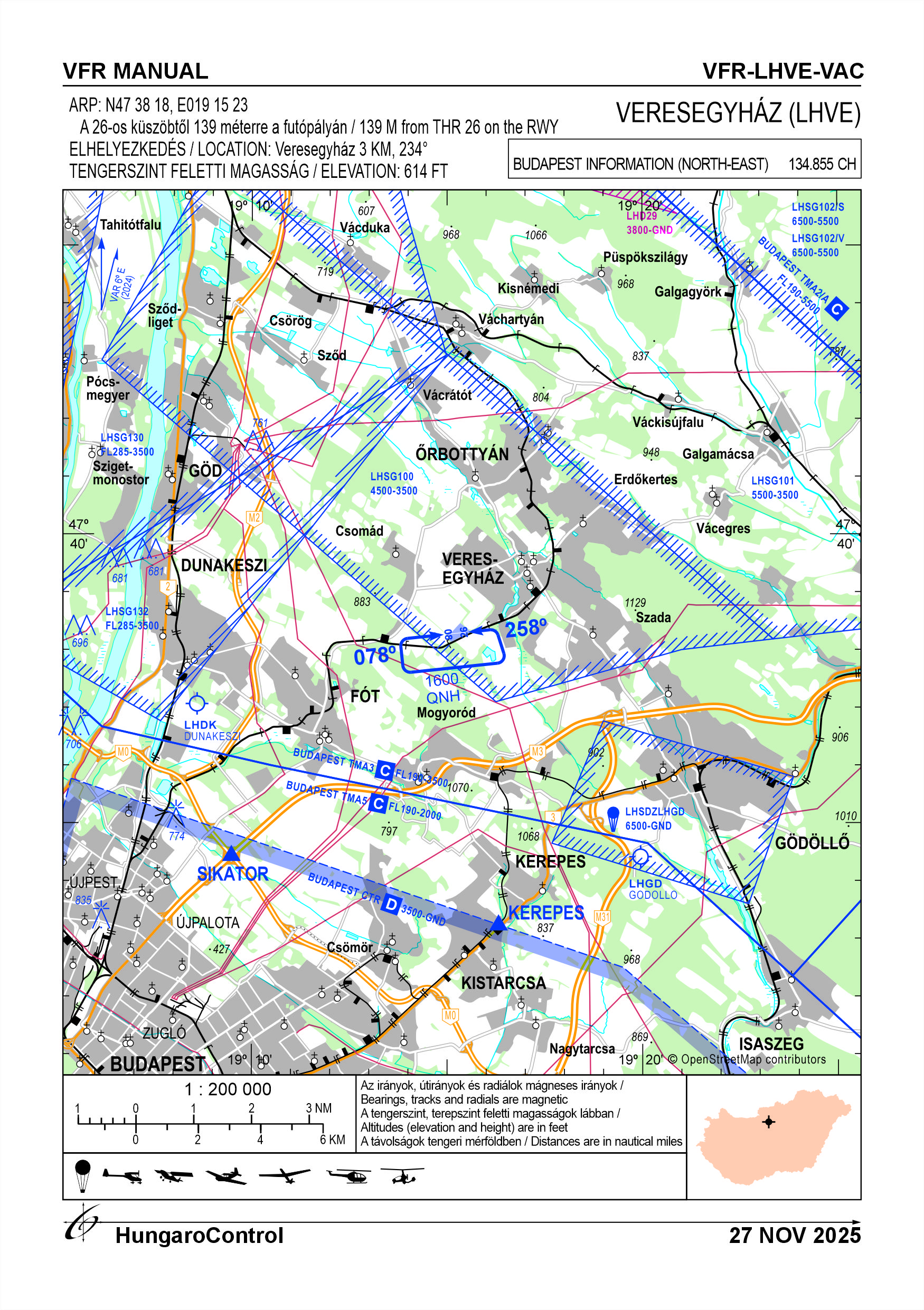
The airport may be used with the prior written permission of the operator, during the airport's operating hours. Only VFR flights may be conducted at the airport, taking into account the VMC weather minima for class "G" airspace. There are no obstacles higher than 60 m above ground level or any terrain obstacles within a 2 km radius of the airport. The airport is located in class "G" uncontrolled airspace below the Budapest TMA sector. The upper limit of uncontrolled airspace above the airport area is 2500 FT AMSL. There is no air traffic service at the airport. In the case of multi-aircraft local flights, two-way radio communication between aircraft is required on the national free-to-use frequency (129.985 MHz) designated in the AlP. Within the framework of the information exchange, announcements that do not qualify as air traffic service may be made on the frequency. After leaving the traffic circle, the aircraft departing from the airport establishes radio contact with the relevant flight information service (North-East information, 134.850 MHz). Engine start-up may be performed under the supervision of external monitoring personnel. Aircraft may use the designated runway for take-off and landing. The 2 percent slope of the track must also be taken into account in performance calculations. No taxiway will be designated in the area outside the designated runway. A turn-around area and a holding area are provided at both ends of the runway. After landing, it is permitted to turn back on the designated runway and taxi to the parking area without disturbing the landing and take-off traffic. In the case of landing and take-off traffic, the runway must be left for the duration of the traffic. Take-off and landing may only be commenced when the taxiing aircraft has left the runway. Motorized aircraft must fly within the designated traffic circle. During arrival and departure procedures, flying over nearby riding stables and the facilities of the Veresegyháza Bear Sanctuary should be avoided if possible. Wild animals are not typical at the airport during daytime conditions, but their appearance cannot be ruled out. For more information, see the Airport Rules.
Activities at the airport (Yes / No)
- Unmanned aerial vehicle (D)
- No
- Ballon (B)
- Yes
- Ultralight (U)
- Yes
- Hang glider (N)
- No
- Short take-off and landing (R)
- Yes
- Landplane (L)
- Yes
- Paraglider (P)
- No
- Glider (G)
- Yes
- Amphibian (A)
- No
- Helicopter (H)
- Yes
- Gyrocopter (G)
- Yes
- Tilt-wing aircraft (T)
- No
- Other (O)
- NIL
38. Noise abatement procedures
For powered aircraft, the total number of operations during the busiest 6 months of the year must not exceed 4,500. Powered aircraft must follow the designated right 08 / left 26 traffic circle and altitude. Flying over the nearby Bear Lodge area and nearby riding stables at altitudes below QNH 1,600 feet is prohibited. Flights over populated areas below QNH 2,000 feet should be avoided during arrival and departure procedures. Due to the nearby residential areas and facilities, we do not conduct practice and training flights in the vicinity of the airport. During the airport's operating hours, the engine of a motorized aircraft may be operated without restriction for the purpose of warming up and engine testing in accordance with the normal operating regulations of the given aircraft. Further information can be found in the current Airport Rules.
39. Aerodrome charges
See on the webpage: http://setarepulesek.hu/index.php/repulotereink/veresegyhaz-airfield
40. Additional information
For more information, see the Airport Rules.
41. Aerodrome obstacles
- No obstacle text
- NIL
- RWY designator
- NIL
- Obstacle type
- NIL
- Elevation
- NIL
- Height
- NIL
- Coordinates
- NIL
- Remarks
- NIL