LHST Szatymaz Airport
Last updated: 2026.03.19.
1. Aerodrome identification
- Aerodrome location indicator
- LHST
- Aerodrome name
- Szatymaz Airport
- Aerodrome place name
- Szatymaz
2. Contact
- Address
- 6763 Szatymaz, Reptéri bekötő út 1.
- Phone
- +36-70/701-4883, +36-70/411-6809, +36-70/945-1637
- szatymazairfield@gmail.com
3. Gallery
Teljes képernyő
Teljes
képernyő bezárása
Teljes képernyő
Teljes
képernyő bezárása

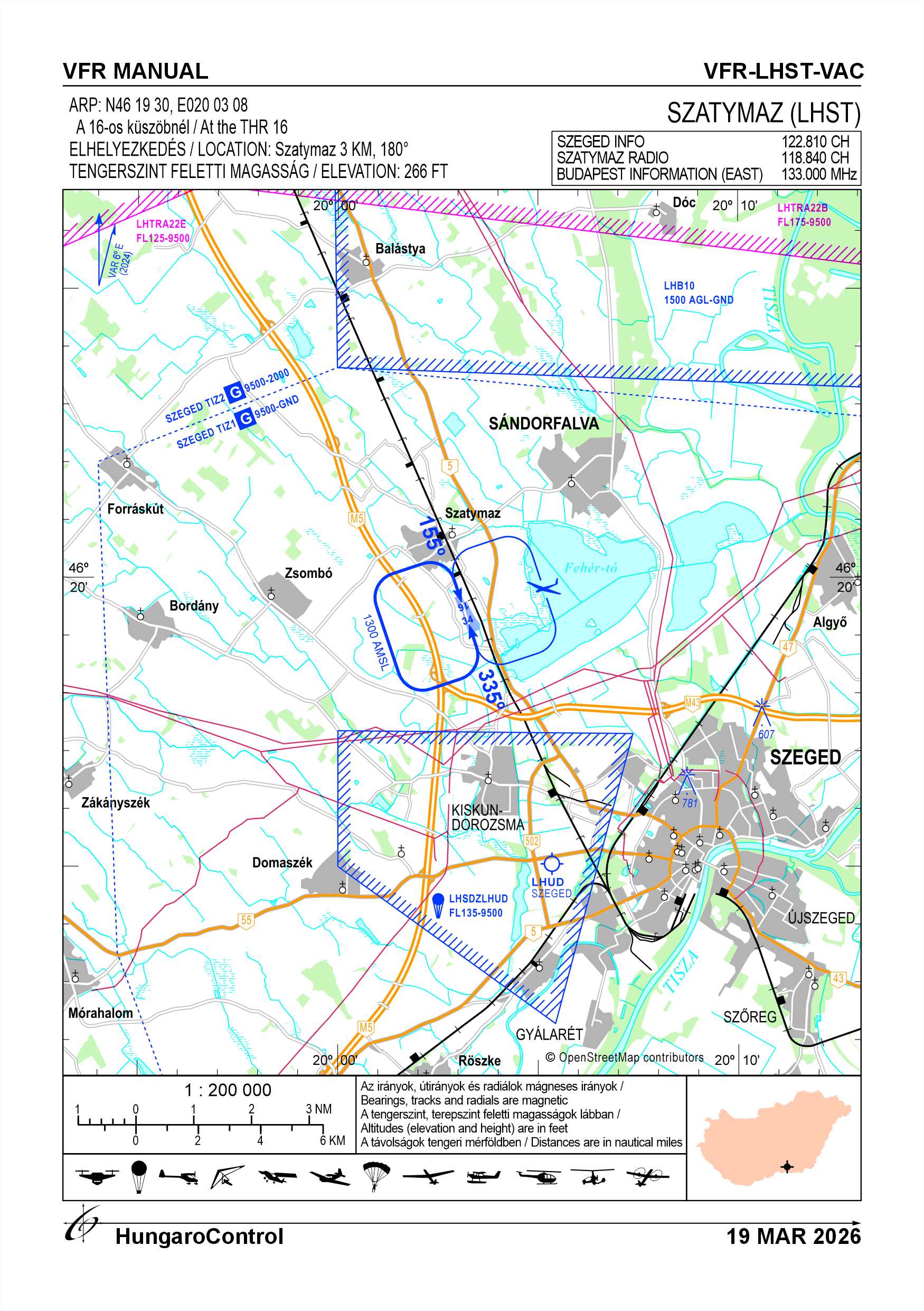
5. Aerodrome geographical and administrative data
ARP data
- Coordinates
- 461930N 0200308E
- Site at aerodrome
- At the THR 16
Location of aerodrome
- Distance from city (KM)
- Szatymaz 3 KM
- Direction from city
- 180°
- Elevation
- 266 FT
Magnetic variation data
- Degree of magnetic variation ( °)
- 5°44' E
- Annual change ( °)
- +0°08'
- Year of survey
- 2024
Aerodrome operator data
- Name
- Szatymaz Repülőtér Kft.
- Address
- 6763 Szatymaz, Reptéri bekötő út 1.
- Phone
- +36-70/701-4883, +36-70/411-6809, +36-70/945-1637
- Fax
- NIL
- Web
- NIL
- szatymazairfield@gmail.com
Aerodrome data
- Name
- 6763 Szatymaz, Reptéri bekötő út 1.
- Phone
- +36-70/945-1637 (Szabó Péter)
- Fax
- NIL
- Web
- NIL
- szatymazairfield@gmail.com
- AFS
- NIL
- SITA
- NIL
- Others
- NIL
- Type of traffic allowed at the aerodrome
- VFR
- Remarks
- Special airport for civil use
- Responsible operator's name
- NIL
- Time logged
- NIL
6. Air traffic services communication facitlities
|
Service designation
|
Call sign
|
Channel
|
Languages used
|
Hours of operation
|
Remarks
|
|---|---|---|---|---|---|
| Szatymaz Rádió | Szatymaz Rádió | 118.840 CH | HU | NIL | The frequency assigned to the airport. There is no air traffic service. |
7. Operation hours
- AD Administration
- Between maximum sunrise -30 minutes and maximum sunset +45 minutes, but not longer than twilight, whichever is the stricter, and in conditions suitable for VFR flights
- Customs and immigration
- NIL
- Health and sanitation
- NIL
- AIS Briefing Office
- NIL
- ATS Reporting Office (ARO)
- NIL
- MET Briefing Office
- NIL
- ATS
- NIL
- Fuelling
- NIL
- Handling
- NIL
- Security
- H24Area monitored by camera
- De-icing
- NIL
- Remarks
- NIL
8. Available handling services and facilities
- Cargo-handling facilities
- NIL
- Fuel types
-
AVGAS 100LL, MOGAS
Fuel is available exclusively to organizations with a facility or headquarters at the airport.
- Oil types
- TOTAL 120, SHELL 100, Oil is provided only to organisations established or based at the airport
- Fuelling facilities and capacity
- Container well
- De-icing facilities
- NIL
- Hangar space for visiting aircraft
- Only possible in advance agreement with the operator, outdoors or in a hangar
- Repair facilities for visiting aircraft
- PART CAO organisation operates at the airport, but only pre-arranged maintenance with this organisation is possible
- Remarks
- Fuel/oil is provided only to organisations established or based at the airport
9. Passenger facilities
- Hotels
- Airfield Motel avaliable by prior arrangement
- Restaurants
- Restaurant in the village
- Transportation
- Bus and taxi, train station 2 km away (Szeged-Budapest route)
- Medical facilities
- Hospital in the city, doctor in the village
- Bank and Post Office
- Post office in the village
- Tourist Office
- In the city, handouts are avaliable at the airfield
- Remarks
- NIL
10. Available rescue and fire fighting services
- Aerodrome catogory for fire fighting
- Categories 1, 2 and up to 3 as defined in Annex 3 to Government Decree 85/2024 (IV.17) depending on the activity actually being carried out. Only organisations authorised in writing may carry out economic activities.
- Available rescue and fire fighting services
- A total of 7 persons, but they are only on duty subject to the activities authorised by the operator, in the number of staff required for the activity.
- Rescue and fire fighting equipment
- Fire extinguishers and equipment in category 3 of Annex 3 of Government Decree 85/2024 (IV.17).
- Capability for removal of disabled aircraft
- An all-terrain vehicle and a tractor are available for moving
- Remarks
- NIL
11. Clearing
- Types of clearing equipment
- NIL
- Clearance priorities
- NIL
- Remarks
- NIL
12. Aprons
|
Designation
|
Surface
|
Strength
|
Remarks
|
Designator
|
|---|---|---|---|---|
| NIL | NIL | NIL | NIL | NIL |
13. Taxiways
|
Designation
|
Surface
|
Strength
|
Width (M)
|
Remarks
|
Designatior
|
|---|---|---|---|---|---|
| NIL | NIL | NIL | NIL | NIL | NIL |
14. Checkpoints
Altimeter checkpoints and locations data
- Coordinates
- NIL
- Technical data
- NIL
- VOR checkpoints
- NIL
- INS checkpoints
- NIL
- Remarks
- NIL
15. Surface movement guidance and control system and markings
- Use of aircraft stand ID signs, TWY guide lines and visual docking/parking guidance system of aircraft stands
- NIL
- RWY and TWY markings and lighting
- The runway is marked with a white border and thresholds
- Stop bars
- NIL
- Remarks
- NIL
16. Runways (RWY)
|
RWY designator
|
True bearing
|
Magnetic bearing
|
Length (M)
|
Width (M)
|
Strength
|
Surface
|
Remarks
|
|---|---|---|---|---|---|---|---|
| 16 | 161° | 155° | 700 | 30 | 10 t (5.7 t) | Grass |
The airport can only be used by aircraft under 5.7 t MTOW, except for Air Force helicopters, which can use it without restriction. The operator may prohibit the movement of certain aircraft depending on the wetness of the surface, and in the event of significant turbulence, the operator shall close the aerodrome. |
| 34 | 341° | 335° | 700 | 30 | 10 t (5.7 t) | Grass |
The airport can only be used by aircraft under 5.7 t MTOW, except for Air Force helicopters, which can use it without restriction. The operator may prohibit the movement of certain aircraft depending on the wetness of the surface, and in the event of significant turbulence, the operator shall close the aerodrome. |
17. Aerodrome obstacles
|
RWY designator
|
Obstacle type
|
Elevation
|
Height
|
Coordinates
|
Remarks
|
|---|---|---|---|---|---|
| 16 | Tree line | 282 FT | 16 FT | 461905N 0200320E | NIL |
| 34 | Tree line | 310 FT | 50 FT | 461941N 0200300E | NIL |
18. Stopways (SWY)
|
RWY designator
|
Length (M)
|
Width (M)
|
Strength
|
Surface
|
Slope (%)
|
Remarks
|
|---|---|---|---|---|---|---|
| 16 | NIL | NIL | NIL | NIL | NIL | NIL |
| 34 | NIL | NIL | NIL | NIL | NIL | NIL |
19. Clearways (CWY)
|
RWY designator
|
Length (M)
|
Width (M)
|
Slope (%)
|
Remarks
|
|---|---|---|---|---|
| 16 | NIL | NIL | NIL | NIL |
| 34 | NIL | NIL | NIL | NIL |
20. STRIP
|
RWY designator
|
Length (M)
|
Width (M)
|
Remarks
|
|---|---|---|---|
| 16 | 785 | 30 | NIL |
| 34 | 785 | 30 | NIL |
21. RESA
|
RWY designator
|
Length (M)
|
Width (M)
|
Surface
|
Obstacle free zone (OFZ)
|
Remarks
|
|---|---|---|---|---|---|
| 16 | NIL | NIL | NIL | NIL | NIL |
| 34 | NIL | NIL | NIL | NIL | NIL |
22. Declared distances
|
RWY designator
|
TORA (M)
|
TODA (M)
|
ASDA (M)
|
LDA (M)
|
Remarks
|
|---|---|---|---|---|---|
| 16 | 700 | 700 | 700 | 700 | NIL |
| 34 | 700 | 700 | 700 | 700 | NIL |
23. Approach lighting
|
RWY designator
|
Type
|
Length (M)
|
Intensity
|
Remarks
|
|---|---|---|---|---|
| 16 | NIL | NIL | NIL | NIL |
| 34 | NIL | NIL | NIL | NIL |
24. Threshold lighting
|
RWY designator
|
Colour
|
Wing bar lights
|
Remarks
|
|---|---|---|---|
| 16 | NIL | NIL | NIL |
| 34 | NIL | NIL | NIL |
25. Visual approach slope indicator system lighting
|
RWY designator
|
Type
|
Data
|
Remarks
|
|---|---|---|---|
| 16 | NIL | NIL | NIL |
| 34 | NIL | NIL | NIL |
26. Touchdone zone lighting
|
RWY designator
|
Length of lighting (M)
|
Remarks
|
|---|---|---|
| 16 | NIL | NIL |
| 34 | NIL | NIL |
27. Runway centreline lighting
|
RWY designator
|
Length (M)
|
Spacing (M)
|
Colour
|
Intensity
|
Remarks
|
|---|---|---|---|---|---|
| 16 | NIL | NIL | NIL | NIL | NIL |
| 34 | NIL | NIL | NIL | NIL | NIL |
28. Runway edgeline lighting
|
RWY designator
|
Length (M)
|
Spacing (M)
|
Colour
|
Intensity
|
Remarks
|
|---|---|---|---|---|---|
| 16 | NIL | NIL | NIL | NIL | NIL |
| 34 | NIL | NIL | NIL | NIL | NIL |
29. Runway end lighting
|
RWY designator
|
Colour
|
Remarks
|
|---|---|---|
| 16 | NIL | NIL |
| 34 | NIL | NIL |
30. Runway wing bars lighting
|
RWY designator
|
Colour
|
Remarks
|
|---|---|---|
| 16 | NIL | NIL |
| 34 | NIL | NIL |
31. Stopway lighting
|
RWY designator
|
Length of lighting (M)
|
Colour
|
Remarks
|
|---|---|---|---|
| 16 | NIL | NIL | NIL |
| 34 | NIL | NIL | NIL |
32. Other lighting, secondary power supply
- ABN/IBN location, charasteristics and hours of operation
- NIL
- LDI location and lighting
- NIL
- Anemometer location and lighting
- On top of the main hangar, illumination: NIL
- 4Centre line lighting
- NIL
- TWY edge line lighting
- NIL
- Secondary power supply
- NIL
- Switch-over time
- NIL
- Remarks
- NIL
33. Helicopter landing area
- Coordinates TLOF or THR of FATO
- NIL
- TLOF and/or FATO elevation
- NIL
- TLOF and FATO area marking
- NIL
- TLOF and FATO area dimensions (M)
- NIL
- TLOF and FATO area surface
- NIL
- TLOF and FATO area strength
- NIL
- True BRG of FATO
- NIL
- MAG BRG of FATO
- NIL
- Declared distances available
- NIL
- APP and FATO lighting
- NIL
- Remarks
- NIL
34. Meteorological information provider
- Associated MET Office
- HungaroMet Magyar Meteorológiai Szolgáltató Nonprofit Zrt. (HungaroMet Zrt.), Unit of Aviation Meteorology
- Hours of service
- H24
- Office responsible for TAF preparation
- HungaroMet Magyar Meteorológiai Szolgáltató Nonprofit Zrt. (HungaroMet Zrt.), Unit of Aviation Meteorology
- Periods of validity
- NIL
- Interval of issuance
- NIL
- Type of landing forecast
- NIL
- Landing forecast interval of issuance
- NIL
- Briefing/consultation provided
- Written briefing: https://aviation.met.hu;Consultation via phone: +36-90/603-424;Consultation via e-mail: rvo@met.hu;
- Flight documentation
- Charts, abbreviated plain language text
- Language(s) used
- HU, EN
- Charts and other information available for briefing or consultation
- Charts, aerodrome reports and forecasts in EUR region, area forecasts, MET. observations and warnings in Budapest FIR
- Supplementary equipment available for providing information
- Self-briefing via aviation.met.hu
- ATS Units provided with information
- Budapest FIC (on request)
- Remarks
- NIL
35. Air traffic service airspace
- Designation
- NIL
- Lateral limits
- NIL
- Vertical limits (FT)
- NIL
- Airspace classification
- NIL
- ATS unit call sign
- NIL
- Languages used
- NIL
- Transition altitude (FT)
- NIL
- Remarks
- NIL
37. Local aerodrome regulations
Activities that can be carried out at the airport
Various types of flying activities (paragliding (towed and winched), SES, UL, glider, motorised, hot-air balloon, parachute, airship, paraglider, model aircraft, etc.) can be carried out at the airport, both individually and in combination.
The airport is part of the Lt. 37 § (1) ba) of the Civil Aviation Act, which is a special airport for civil purposes. Subject to the exceptions set out in § 41(6) to (7), it may be used only with the permission of the operator.
Without any prior notification, the activity of aircraft and their crews using the airport shall constitute unauthorised use.
Exceptions to this rule shall be made in the case of State, military, law enforcement and disaster relief aircraft and their crews in an emergency situation, but only for the purpose of performing their rescue duties. Use for training purposes shall not be considered as rescue and shall not be exempted.
When carrying out any aviation activity, the following rules shall be observed at Szatymaz airport, in addition to the Hungarian aviation legislation, professional rules and international treaties:
Local rules for the execution of individual operations and the cooperation of parallel operations:
- Only aircraft whose commander has been authorised by the operator to use the airport may use the airport.
- The main rule for the installation of glider take-off positions is that priority shall be given to operations on the designated runway. This rule shall not, however, be used in contravention of the provisions of the PART-SERA "Rules of the Air", in particular those relating to low power non-powered aeroplanes.
- The glider launch site may be set up throughout the field of operations.
- The parallel operation of a grass runway and a glider flight facility is permitted.
- Launch sites shall maintain two-way direct radio contact with each other.
- Where there are several types of operations at the aerodrome, the aerodrome operator or his delegate shall determine the equipment and separation of the take-off positions and shall coordinate the day-to-day operations of the different sections.
- All aircraft and flying equipment may use the entire field of operations for landing and take-off.
- Flocking of aircraft on the grassy area in front of the hangars.
Leaving the traffic circle of Szatymaz, aircraft with engines that have not been previously notified to Szeged Info must radio in on 122.810 MHz. No check-in is required for pre-coordinated powered flights, aircraft not leaving the active Satymaz incident airspace, and aircraft and aircraft as defined in the SERA rules, subject to the SERA rules.
Take-offs and landings from the airport in the direction(s) of unplanned obstacles outside the airport shall only be permitted if the relevant-current performance calculation for the type concerned indicates that these unplanned obstacles can be safely avoided.
For example:
Eastbound:
- High voltage cable, on poles NW-SE track (height: max10m)
- electrified railway track
- tree belt
West direction:
- airport buildings, hangars
- Wooded area
North direction:
- wooded area
Coordination of day-to-day operations shall be organised on a daily basis by the manager in charge or his/her deputies, depending on the weather and the operation or operations of the aircraft.
Powered aircraft should normally use the westbound traffic circle, unpowered aircraft should normally use the eastbound traffic circle, but may deviate from this during the day-to-day coordination of the pilot-in-command or his/her representative (e.g. changing towing airspace, etc.) The traffic circle is 1300 feet AMSL. Each aircraft or aircraft may deviate from this, if justified, taking into account the characteristics of the aircraft or aircraft or its specific flight task. The first turn of the traffic circle is located in a southerly direction on the extended take-off line, on the north side of the Szeged bypass motorway section and on the south side of the industrial building "CE Glass", the second turn is located in a westerly direction west of the road in the extension of the Neszűrjhegyi road and east of the M5 motorway, while the third roundabout is located in a north-westerly direction from the "Gulyás corner", the fourth roundabout is located approximately 250 m east of the intersection of the third roundabout and the extension of the railway line. In the case of a southbound take-off, the first turn of the traffic circle in the easterly direction is the same as the westerly circle in the southerly direction, while the second turn is located on the White Lake line, the third turn in this case is the "horse farm", and the fourth turn is located approximately 250 m easterly from the intersection of the third turn and the perpendicular to the track axis. In the case of circles to the north, the opposite direction and order are described.
Aircraft/aircraft traffic at the airport:
Ground movements of aircraft/aircraft shall be conducted with individual separation in the airport operations area. All taxiing aircraft shall give priority to aircraft taking off and landing. The recommended taxiing speed is 20km/h. When aircraft/aircraft are operating in the airspace and in the movement area of the aerodrome, aircraft/aircraft crews shall keep a constant watch on traffic to detect and prevent potential collision hazards.
Engine tests shall be conducted only in such a way that the propeller winds generated and the objects picked up do not endanger or disturb any person or object. Passing in front of or behind an aircraft conducting an engine test on foot or by any other means of transport shall not be permitted within a distance of 30 metres. Except in the case of an engine test prior to take-off, the engine test may only be conducted by an aircraft equipped with a brake lance. An engine start shall only be performed when no person or readily movable object is present within 10 m of the engine to be started, other than the person in the aircraft/aircraft or the person supervising the engine start from outside, if applicable.
It is the responsibility of the commander of the particular aircraft/aircraft to determine which runway or, in the case of take-off and landing from an operational field, which heading to use for take-off and landing, taking into account the noise abatement procedure and the performance data of the particular aircraft/aircraft, for the given wind conditions.
All take-offs and landings must be conducted in such a manner as not to interfere with or endanger other aircraft taking off or landing.
With the exception of sailplanes, fuel may only be refuelled at the designated refuelling point, with the aircraft to be refuelled being grounded, in compliance with the relevant fire and safety regulations. Gliders may also be refuelled at the place where they are stowed, subject to compliance with the applicable fire and safety rules.
All aircraft departing from and arriving at the airport must be equipped with a functioning FLARM device, except with the permission of the operator.
The owner or operator of the aircraft must ensure the removal of disabled aircraft. The operator of the aerodrome may provide a limited vehicle for removal from the runway or operational field to the ground.
The use of radios is mandatory! In all cases, a turn to the traffic circle, to the rear short wall (base leg) or to the final straight (final) must be reported even if there is no response from the ground radio station.
Gliders may only take off with a valid flight plan or an airspace permit, which must be obtained by the glider commander (This point does not apply to competitors in the case of organised competition).
In all cases, gliders must be flown "long" without blocking the runway, unless the pilot can ensure that within 1 minute of landing and stopping, the glider is pushed off the runway and no other traffic is expected within 3 minutes of landing.
The operator will endeavour to keep wild animals out, but their presence cannot be excluded. The western side of the airport is partly fenced and partly wooded, while the northern and eastern sides are protected by ditches. Waterfowl, rabbits and deer may be present in the airport area.
A building ban/restriction has been introduced in the municipality's zoning plan for the airport area, maps 4/4/1, 4/4/2, 4/4/3 (These maps refer to the building restriction only).
For more information, see the Airport Rules.
Activities at the airport (Yes / No)
- Unmanned aerial vehicle (D)
- Yes
- Ballon (B)
- Yes
- Ultralight (U)
- Yes
- Hang glider (N)
- Yes
- Short take-off and landing (R)
- Yes
- Landplane (L)
- Yes
- Paraglider (P)
- Yes
- Glider (G)
- Yes
- Amphibian (A)
- Yes
- Helicopter (H)
- Yes
- Gyrocopter (G)
- Yes
- Tilt-wing aircraft (T)
- Yes
- Other (O)
- NIL
38. Noise abatement procedures
The preferred direction for take-off is between 160 and 190 degrees, even in light tailwinds, and for landing between 340 and 010 degrees. Avoid flying over the settlement of Szatymaz and flying with powered aircraft below 400 m AGL over Lake White.
39. Aerodrome charges
Landing fee apply.
40. Additional information
For more information, see the Airport Rules.
41. Aerodrome obstacles
- No obstacle text
- NIL
- RWY designator
- NIL
- Obstacle type
- NIL
- Elevation
- NIL
- Height
- NIL
- Coordinates
- NIL
- Remarks
- NIL