LHPK Papkutapuszta Airport
Last updated: 2025.12.25.
1. Aerodrome identification
- Aerodrome location indicator
- LHPK
- Aerodrome name
- Papkutapuszta Airport
- Aerodrome place name
- Siófok
2. Contact
- Address
- 8611 Siófok-Balatonkiliti, 0223/5 hrsz.
- Phone
- +36-70/311-2272, +36-70/311-2275
- info@aeromedia.hu, papkuta@gmail.com
3. Gallery
Teljes képernyő
Teljes
képernyő bezárása
Teljes képernyő
Teljes
képernyő bezárása
5. Aerodrome geographical and administrative data
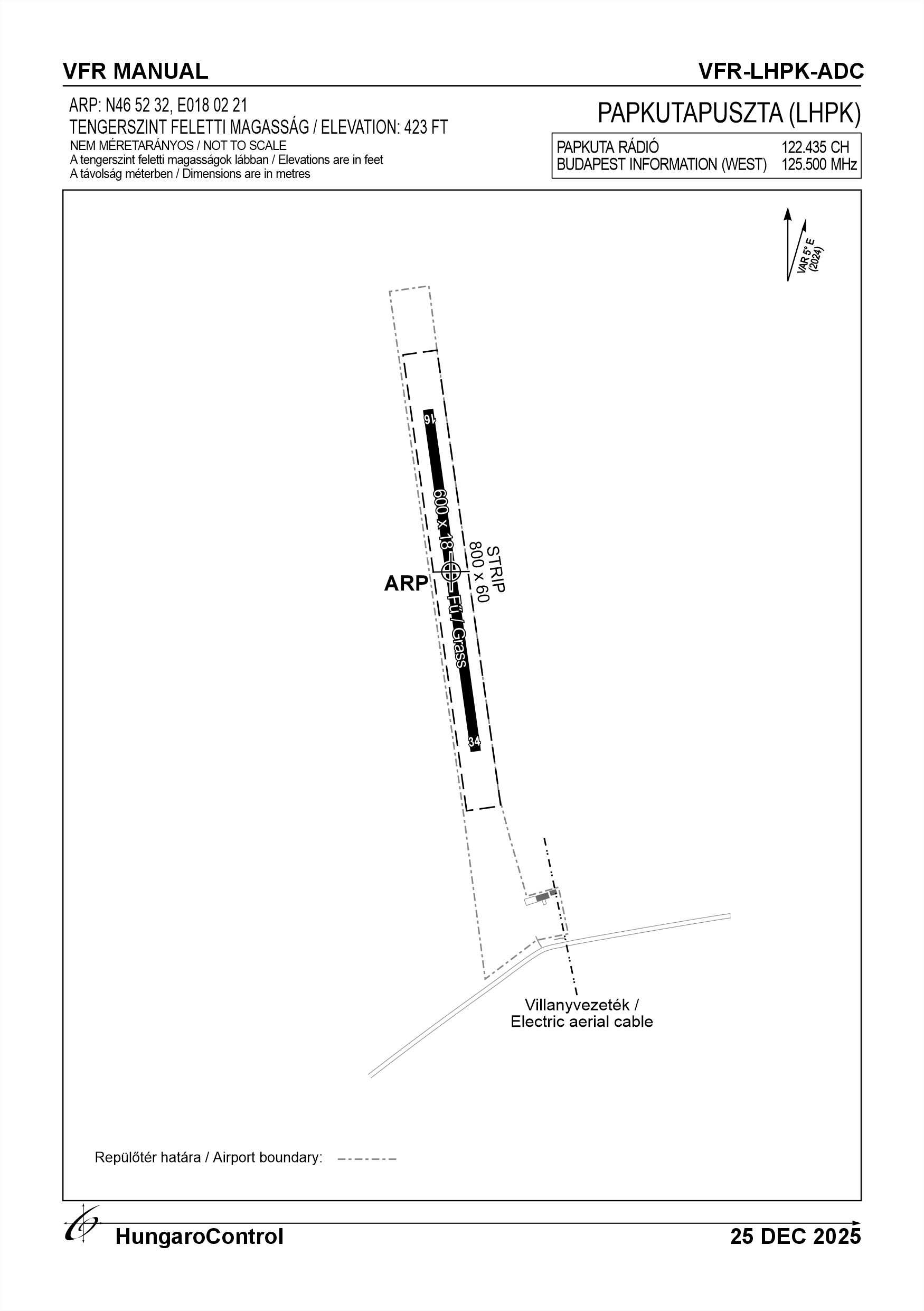
ARP data
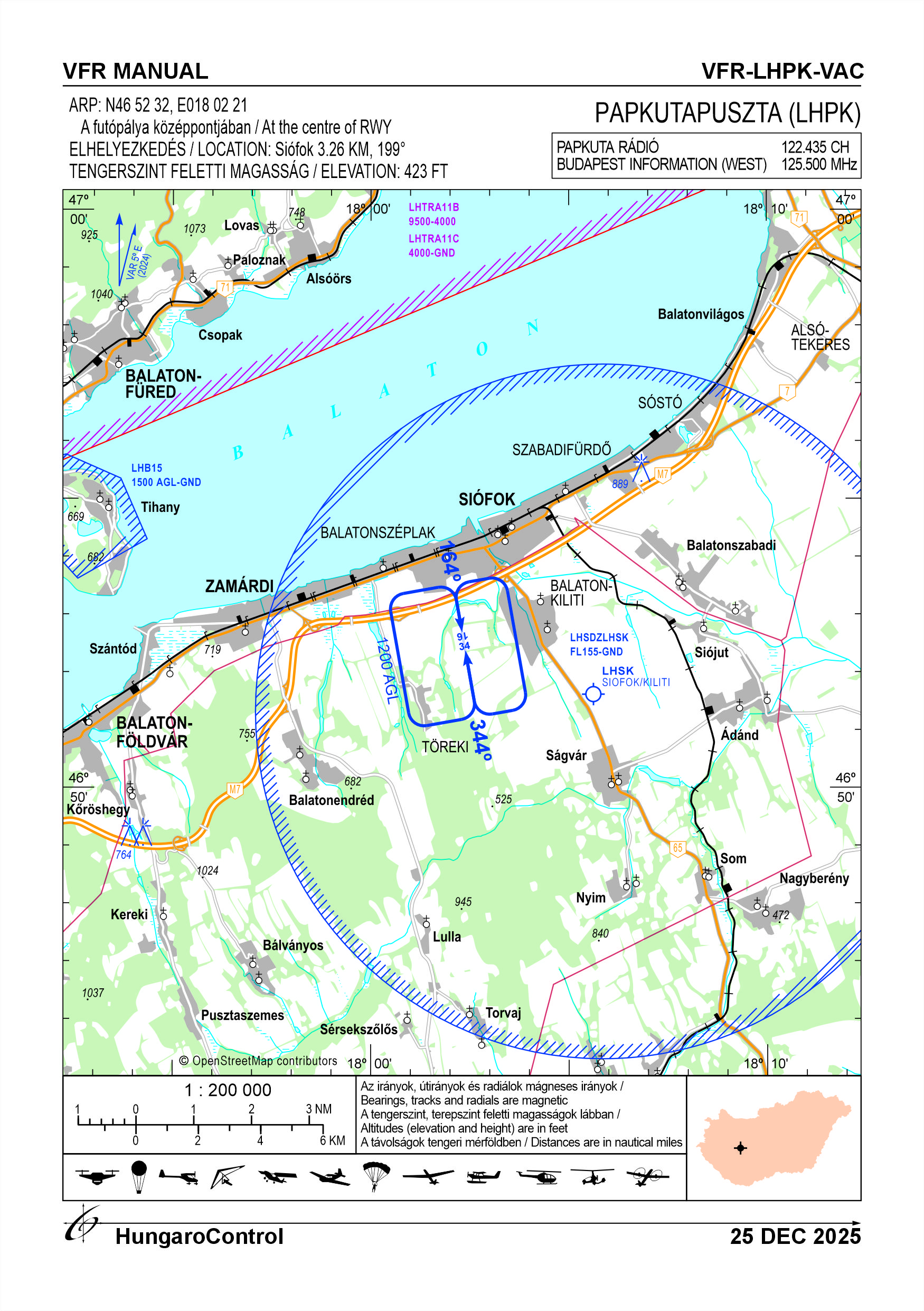
- Coordinates
- 465232N 0180221E
- Site at aerodrome
- At the centre of RWY
Location of aerodrome
- Distance from city (KM)
- Siófok 3.26 KM
- Direction from city
- 199°
- Elevation
- 423 FT
Magnetic variation data
- Degree of magnetic variation ( °)
- 5°27' E
- Annual change ( °)
- +0°09'
- Year of survey
- 2024
Aerodrome operator data
- Name
- Aero Média Kft.
- Address
- 8600 Siófok, Küszhegyi u. 4/b. 3/12.
- Phone
- +36-70/311-2272, +36-70/311-2275
- Fax
- NIL
- Web
- NIL
- papkuta@gmail.com
Aerodrome data
- Name
- 8611 Siófok-Balatonkiliti, 0223/5 hrsz.
- Phone
- +36-70/311-2272 (Bódis László)
- Fax
- NIL
- Web
- NIL
- AFS
- NIL
- SITA
- NIL
- Others
- NIL
- Type of traffic allowed at the aerodrome
- VFR
- Remarks
- Special airport for civil use
- Responsible operator's name
- NIL
- Time logged
- NIL
6. Air traffic services communication facitlities
|
Service designation
|
Call sign
|
Channel
|
Languages used
|
Hours of operation
|
Remarks
|
|---|---|---|---|---|---|
| Papkuta Rádió | Papkuta Rádió | 122.435 CH | HU | In opening hours | NIL |
7. Operation hours
- AD Administration
- Between maximum sunrise -30 minutes and maximum sunset +45 minutes, but not longer than twilight, whichever is the stricter, and in conditions suitable for VFR flights on snow-free days.
- Customs and immigration
- NIL
- Health and sanitation
- NIL
- AIS Briefing Office
- NIL
- ATS Reporting Office (ARO)
- NIL
- MET Briefing Office
- NIL
- ATS
- NIL
- Fuelling
- NIL
- Handling
- NIL
- Security
- NIL
- De-icing
- NIL
- Remarks
- NIL
8. Available handling services and facilities
- Cargo-handling facilities
- NIL
- Fuel types
- NIL
- Oil types
- NIL
- Fuelling facilities and capacity
- NIL
- De-icing facilities
- NIL
- Hangar space for visiting aircraft
- NIL
- Repair facilities for visiting aircraft
- NIL
- Remarks
- NIL
9. Passenger facilities
- Hotels
- In the city
- Restaurants
- In the city
- Transportation
- Taxi
- Medical facilities
- In the city
- Bank and Post Office
- In the city
- Tourist Office
- In the city
- Remarks
- NIL
10. Available rescue and fire fighting services
- Aerodrome catogory for fire fighting
- Categories 1, 2 and up to 3 as defined in Annex 3 to Government Decree 85/2024 (IV.17) depending on the activity actually being carried out. Only organisations authorised in writing may carry out economic activities.
- Available rescue and fire fighting services
- A total of 3 persons, but they are only on duty subject to the activities authorised by the operator, in the number of staff required for the activity.
- Rescue and fire fighting equipment
- Fire extinguishers and equipment in category 3 of Annex 3 of Government Decree 85/2024 (IV.17). and a vehicle
- Capability for removal of disabled aircraft
- Tractor
- Remarks
- NIL
11. Clearing
- Types of clearing equipment
- NIL
- Clearance priorities
- NIL
- Remarks
- Depending on the snow cover of the surface, the operator may prohibit the movement of certain aircraft, and in the event of heavy snow, the operator will close the airport.
12. Aprons
|
Designation
|
Surface
|
Strength
|
Remarks
|
Designator
|
|---|---|---|---|---|
| NIL | NIL | NIL | NIL | NIL |
13. Taxiways
|
Designation
|
Surface
|
Strength
|
Width (M)
|
Remarks
|
Designatior
|
|---|---|---|---|---|---|
| NIL | NIL | NIL | NIL | NIL | NIL |
14. Checkpoints
Altimeter checkpoints and locations data
- Coordinates
- NIL
- Technical data
- NIL
- VOR checkpoints
- NIL
- INS checkpoints
- NIL
- Remarks
- NIL
15. Surface movement guidance and control system and markings
- Use of aircraft stand ID signs, TWY guide lines and visual docking/parking guidance system of aircraft stands
- NIL
- RWY and TWY markings and lighting
- RWY: white edges markings and threshold markingsTWY: -
- Stop bars
- NIL
- Remarks
- NIL
16. Runways (RWY)
|
RWY designator
|
True bearing
|
Magnetic bearing
|
Length (M)
|
Width (M)
|
Strength
|
Surface
|
Remarks
|
|---|---|---|---|---|---|---|---|
| 16 | 170° | 164° | 600 | 18 | 10 t (3 t) | Grass |
The airport can only be used below 5.7 t MTOW. The operator may prohibit the movement of certain aircraft depending on the wetness of the surface, and in the event of significant turbulence, the operator shall close the aerodrome. |
| 34 | 350° | 344° | 600 | 18 | 10 t (3 t) | Grass |
The airport can only be used below 5.7 t MTOW. The operator may prohibit the movement of certain aircraft depending on the wetness of the surface, and in the event of significant turbulence, the operator shall close the aerodrome. |
17. Aerodrome obstacles
|
RWY designator
|
Obstacle type
|
Elevation
|
Height
|
Coordinates
|
Remarks
|
|---|---|---|---|---|---|
| 34 | Power line 22 kV | NIL | 10 M | NIL | 170° and 580 M from THR 34 |
| 16 | Power line 100 kV | NIL | 20 M | NIL | 350° and 1270 M from THR 16 |
18. Stopways (SWY)
|
RWY designator
|
Length (M)
|
Width (M)
|
Strength
|
Surface
|
Slope (%)
|
Remarks
|
|---|---|---|---|---|---|---|
| 16 | NIL | NIL | NIL | NIL | NIL | NIL |
| 34 | NIL | NIL | NIL | NIL | NIL | NIL |
19. Clearways (CWY)
|
RWY designator
|
Length (M)
|
Width (M)
|
Slope (%)
|
Remarks
|
|---|---|---|---|---|
| 16 | NIL | NIL | NIL | NIL |
| 34 | NIL | NIL | NIL | NIL |
20. STRIP
|
RWY designator
|
Length (M)
|
Width (M)
|
Remarks
|
|---|---|---|---|
| 16 | 800 | 60 | NIL |
| 34 | 800 | 60 | NIL |
21. RESA
|
RWY designator
|
Length (M)
|
Width (M)
|
Surface
|
Obstacle free zone (OFZ)
|
Remarks
|
|---|---|---|---|---|---|
| 16 | NIL | NIL | NIL | NIL | NIL |
| 34 | NIL | NIL | NIL | NIL | NIL |
22. Declared distances
|
RWY designator
|
TORA (M)
|
TODA (M)
|
ASDA (M)
|
LDA (M)
|
Remarks
|
|---|---|---|---|---|---|
| 16 | 600 | 600 | 600 | 600 | NIL |
| 34 | 600 | 600 | 600 | 600 | NIL |
23. Approach lighting
|
RWY designator
|
Type
|
Length (M)
|
Intensity
|
Remarks
|
|---|---|---|---|---|
| 16 | NIL | NIL | NIL | NIL |
| 34 | NIL | NIL | NIL | NIL |
24. Threshold lighting
|
RWY designator
|
Colour
|
Wing bar lights
|
Remarks
|
|---|---|---|---|
| 16 | NIL | NIL | NIL |
| 34 | NIL | NIL | NIL |
25. Visual approach slope indicator system lighting
|
RWY designator
|
Type
|
Data
|
Remarks
|
|---|---|---|---|
| 16 | NIL | NIL | NIL |
| 34 | NIL | NIL | NIL |
26. Touchdone zone lighting
|
RWY designator
|
Length of lighting (M)
|
Remarks
|
|---|---|---|
| 16 | NIL | NIL |
| 34 | NIL | NIL |
27. Runway centreline lighting
|
RWY designator
|
Length (M)
|
Spacing (M)
|
Colour
|
Intensity
|
Remarks
|
|---|---|---|---|---|---|
| 16 | NIL | NIL | NIL | NIL | NIL |
| 34 | NIL | NIL | NIL | NIL | NIL |
28. Runway edgeline lighting
|
RWY designator
|
Length (M)
|
Spacing (M)
|
Colour
|
Intensity
|
Remarks
|
|---|---|---|---|---|---|
| 16 | NIL | NIL | NIL | NIL | NIL |
| 34 | NIL | NIL | NIL | NIL | NIL |
29. Runway end lighting
|
RWY designator
|
Colour
|
Remarks
|
|---|---|---|
| 16 | NIL | NIL |
| 34 | NIL | NIL |
30. Runway wing bars lighting
|
RWY designator
|
Colour
|
Remarks
|
|---|---|---|
| 16 | NIL | NIL |
| 34 | NIL | NIL |
31. Stopway lighting
|
RWY designator
|
Length of lighting (M)
|
Colour
|
Remarks
|
|---|---|---|---|
| 16 | NIL | NIL | NIL |
| 34 | NIL | NIL | NIL |
32. Other lighting, secondary power supply
- ABN/IBN location, charasteristics and hours of operation
- NIL
- LDI location and lighting
- NIL
- Anemometer location and lighting
- West side of the centre of the RWY
- 4Centre line lighting
- NIL
- TWY edge line lighting
- NIL
- Secondary power supply
- NIL
- Switch-over time
- NIL
- Remarks
- NIL
33. Helicopter landing area
- Coordinates TLOF or THR of FATO
- NIL
- TLOF and/or FATO elevation
- NIL
- TLOF and FATO area marking
- NIL
- TLOF and FATO area dimensions (M)
- NIL
- TLOF and FATO area surface
- NIL
- TLOF and FATO area strength
- NIL
- True BRG of FATO
- NIL
- MAG BRG of FATO
- NIL
- Declared distances available
- NIL
- APP and FATO lighting
- NIL
- Remarks
- NIL
34. Meteorological information provider
- Associated MET Office
- HungaroMet Magyar Meteorológiai Szolgáltató Nonprofit Zrt. (HungaroMet Zrt.), Unit of Aviation Meteorology
- Hours of service
- H24
- Office responsible for TAF preparation
- HungaroMet Magyar Meteorológiai Szolgáltató Nonprofit Zrt. (HungaroMet Zrt.), Unit of Aviation Meteorology
- Periods of validity
- NIL
- Interval of issuance
- NIL
- Type of landing forecast
- NIL
- Landing forecast interval of issuance
- NIL
- Briefing/consultation provided
- Written briefing: https://aviation.met.hu;Consultation via phone: +36-90/603-424;Consultation via e-mail: rvo@met.hu;
- Flight documentation
- Charts, abbreviated plain language text
- Language(s) used
- HU, EN
- Charts and other information available for briefing or consultation
- Charts, aerodrome reports and forecasts in EUR region, area forecasts, MET. observations and warnings in Budapest FIR
- Supplementary equipment available for providing information
- Self-briefing via aviation.met.hu
- ATS Units provided with information
- Budapest FIC (on request)
- Remarks
- NIL
35. Air traffic service airspace
- Designation
- NIL
- Lateral limits
- NIL
- Vertical limits (FT)
- NIL
- Airspace classification
- NIL
- ATS unit call sign
- NIL
- Languages used
- NIL
- Transition altitude (FT)
- NIL
- Remarks
- NIL
37. Local aerodrome regulations
The task and responsibility of impressing aircraft lies with the aircraft commander. Powered aircraft start their engines independently. The aircraft commander shall be responsible for this.
Use a registered FLARM device to use the aerodrome In this case, use of the aerodrome for private flights is free of charge.
Aircraft may also use an OGN transmitter, in which case a usage fee will be charged.
If the aircraft has a transponder, it must be operated by the aircraft commander.
When leaving the Papkutapuszta traffic area, aircraft with engines which have not been previously notified to Siófok-Kiliti shall report by radio on 125,435 CH. No call-in is required for pre-coordinated engine-powered flights or aircraft not leaving the LHPK traffic circle, and aircraft and aircraft as defined in the SERA rules, subject to the SERA rules.
Fixed-wing aircraft can only take off and land from the airport in the following directions: runways 16 and 34.
Daily operations are coordinated by the manager in charge or his deputy on a daily basis, depending on the weather and the operation or operations.
Powered aircraft normally use the westbound and eastbound minor traffic circles, unpowered aircraft normally use the westbound traffic circle, but may deviate from this during daily coordination by the accountable manager or his/her deputy (e.g. changing towing airspace, etc.)
Only aircraft whose commander has received permission to use the airport from the operator or owners and the airport technical manager may use the airport.
The operator will endeavour to keep wild animals out, but their presence cannot be excluded.
In the case of an active Drop Zone, flights may be carried out with the consent of the Drop Zone coordination organization.
For more information, see the Airport Rules.
Activities at the airport (Yes / No)
- Unmanned aerial vehicle (D)
- Yes
- Ballon (B)
- Yes
- Ultralight (U)
- Yes
- Hang glider (N)
- Yes
- Short take-off and landing (R)
- Yes
- Landplane (L)
- Yes
- Paraglider (P)
- Yes
- Glider (G)
- Yes
- Amphibian (A)
- Yes
- Helicopter (H)
- Yes
- Gyrocopter (G)
- Yes
- Tilt-wing aircraft (T)
- Yes
- Other (O)
- Aircraft modelling
38. Noise abatement procedures
Noise pollution from ground operations is not a problem due to the distance from populated areas. Whenever possible, these operations should be carried out at the time immediately prior to take-off with the minimum engine power required.
The preferred heading for take-off is heading 34, even in light tailwinds, and for landing is heading 16. Avoid flying over the settlements of Balatonkiliti and Töreki, and flying over Lake Balaton with powered aircraft below 1000 feet AGL.
The preferred heading for take-off is heading 34, even in light tailwinds, and for landing is heading 16. Avoid flying over the settlements of Balatonkiliti and Töreki, and flying over Lake Balaton with powered aircraft below 1000 feet AGL.
39. Aerodrome charges
NIL
40. Additional information
For more information, see the Airport Rules.
41. Aerodrome obstacles
- No obstacle text
- NIL
- RWY designator
- NIL
- Obstacle type
- NIL
- Elevation
- NIL
- Height
- NIL
- Coordinates
- NIL
- Remarks
- NIL