LHMC Miskolc City Airport
Last updated: 2026.03.19.
1. Aerodrome identification
- Aerodrome location indicator
- LHMC
- Aerodrome name
- Miskolc City Airport
- Aerodrome place name
- Miskolc
2. Contact
- Address
- Miskolc, I. ker. 0792/2 hrsz. külterület
- Phone
- +36-70/202-1126 (Drótos László)
- drotoslaszlo@freemail.hu
3. Gallery
Teljes képernyő
Teljes
képernyő bezárása
Teljes képernyő
Teljes
képernyő bezárása
5. Aerodrome geographical and administrative data
ARP data
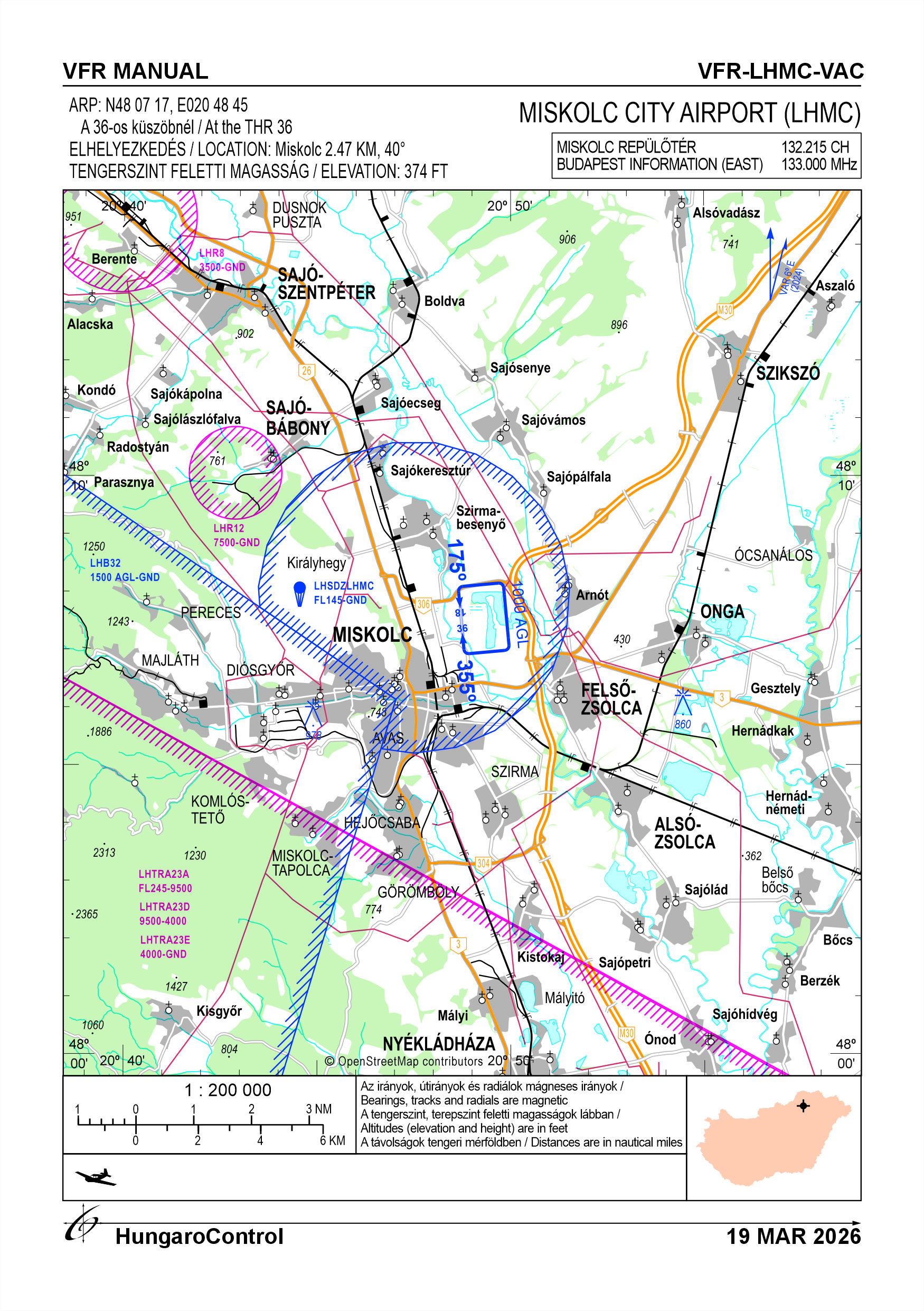
- Coordinates
- 480717N 0204845E
- Site at aerodrome
- At the THR 36
Location of aerodrome
- Distance from city (KM)
- Miskolc 2.47 KM
- Direction from city
- 040°
- Elevation
- 374 FT
Magnetic variation data
- Degree of magnetic variation ( °)
- 6,2° E
- Annual change ( °)
- +0,1°
- Year of survey
- 2024
Aerodrome operator data
- Name
- MATASZ B.A.Z. Vármegyei Miskolci Repülő Egyesülete
- Address
- 3557 Bükkszentkereszt, Napsugár u. 12.
- Phone
- +36-70/202-1126 (Drótos László)
- Fax
- NIL
- Web
- NIL
- drotoslaszlo@freemail.hu
Aerodrome data
- Name
- Miskolc, I. ker. 0792/2 hrsz. külterület
- Phone
- +36-70/202-1126
- Fax
- NIL
- Web
- NIL
- drotoslaszlo@freemail.hu
- AFS
- NIL
- SITA
- NIL
- Others
- NIL
- Type of traffic allowed at the aerodrome
- VFR
- Remarks
- Special airport for civil use, Only PPR
- Responsible operator's name
- NIL
- Time logged
- NIL
6. Air traffic services communication facitlities
|
Service designation
|
Call sign
|
Channel
|
Languages used
|
Hours of operation
|
Remarks
|
|---|---|---|---|---|---|
| Miskolc Repülőtér | Miskolc Repülőtér | 132.215 CH | HU | NIL | NIL |
7. Operation hours
- AD Administration
- With the prior permission of the owner from 08:00 LT until the end of civil twilight. Airport operating hours are from April - 30 September due to weather conditions.
- Customs and immigration
- NIL
- Health and sanitation
- NIL
- AIS Briefing Office
- NIL
- ATS Reporting Office (ARO)
- NIL
- MET Briefing Office
- NIL
- ATS
- NIL
- Fuelling
- You may only refuel with your own fuel
- Handling
- NIL
- Security
- NIL
- De-icing
- NIL
- Remarks
- NIL
8. Available handling services and facilities
- Cargo-handling facilities
- NIL
- Fuel types
- NIL
- Oil types
- NIL
- Fuelling facilities and capacity
-
3 x 20-liter flat-bottomed fuel cans
1 x 5-liter flat-bottomed funnel with a deer-hide filter
1 x fuel-filling ladder
- De-icing facilities
- NIL
- Hangar space for visiting aircraft
- 15 aircraft
- Repair facilities for visiting aircraft
- NIL
- Remarks
- NIL
9. Passenger facilities
- Hotels
- NIL
- Restaurants
- NIL
- Transportation
- NIL
- Medical facilities
- NIL
- Bank and Post Office
- NIL
- Tourist Office
- NIL
- Remarks
- NIL
10. Available rescue and fire fighting services
- Aerodrome catogory for fire fighting
- Category 3 as defined in Annex 3 to Government Decree 85/2024 (IV.17).
- Available rescue and fire fighting services
- At least 1 person, if required to perform the activity / per operating day, a person holding a fire safety certification as prescribed by Decree 45/2011 (XII.7.) of the Ministry of the Interior
- Rescue and fire fighting equipment
-
The equipment specified in Section 2.9 of Annex 3 to Government Decree No. 85/2024 (April 17).
Available firefighting capacity: 10 units of the 55A 233B C (ABC) dry powder fire extinguishers with a maximum capacity of 12 kg, corresponding to the firefighting capacity of 150 OE as defined in Decree No. 54/2014 of the Ministry of the Interior.
- Capability for removal of disabled aircraft
-
1 passenger car with a tow bar
crane trailer in the citymotorized aircraft transport vehicle
- Remarks
- NIL
11. Clearing
- Types of clearing equipment
- NIL
- Clearance priorities
- NIL
- Remarks
- NIL
12. Aprons
|
Designation
|
Surface
|
Strength
|
Remarks
|
Designator
|
|---|---|---|---|---|
| NIL | NIL | NIL | NIL | NIL |
13. Taxiways
|
Designation
|
Surface
|
Strength
|
Width (M)
|
Remarks
|
Designatior
|
|---|---|---|---|---|---|
| NIL | NIL | NIL | NIL | NIL | NIL |
14. Checkpoints
Altimeter checkpoints and locations data
- Coordinates
- NIL
- Technical data
- NIL
- VOR checkpoints
- NIL
- INS checkpoints
- NIL
- Remarks
- NIL
15. Surface movement guidance and control system and markings
- Use of aircraft stand ID signs, TWY guide lines and visual docking/parking guidance system of aircraft stands
- NIL
- RWY and TWY markings and lighting
-
RWY: white edges markings and threshold markings
TWY: -
Lighting: N/A
- Stop bars
- NIL
- Remarks
- NIL
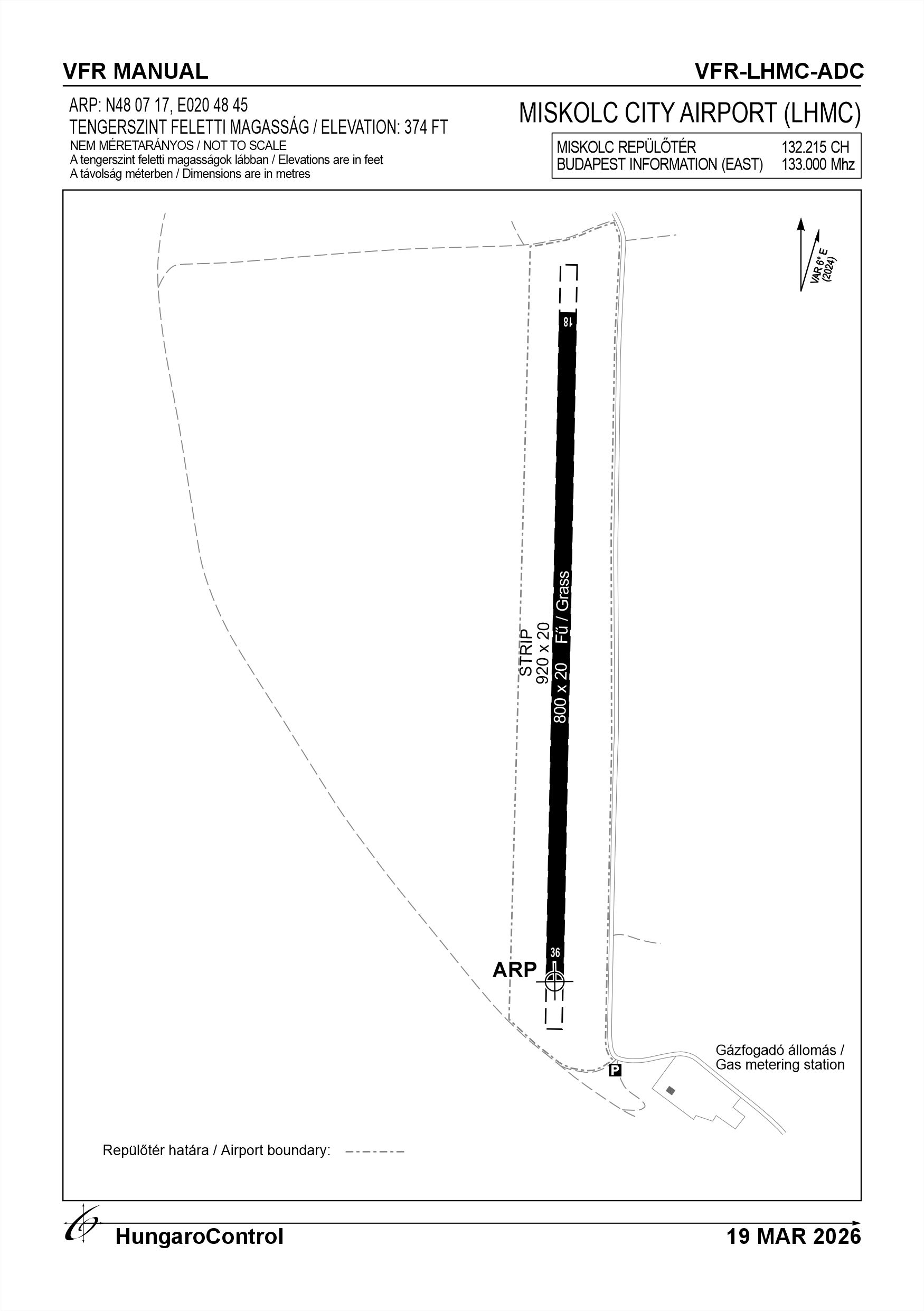
16. Runways (RWY)
|
RWY designator
|
True bearing
|
Magnetic bearing
|
Length (M)
|
Width (M)
|
Strength
|
Surface
|
Remarks
|
|---|---|---|---|---|---|---|---|
| 18 | 182° | 175° | 800 | 20 | 5.5 t (2.0 t) | Grass | The airport manager can provide information about runway conditions upon request. Phone number: +36-70/205-2203 |
| 36 | 002° | 355° | 800 | 20 | 5.5 t (2.0 t) | Grass | The airport manager can provide information about runway conditions upon request. Phone number: +36-70/205-2203 |
17. Aerodrome obstacles
|
RWY designator
|
Obstacle type
|
Elevation
|
Height
|
Coordinates
|
Remarks
|
|---|---|---|---|---|---|
| 36 | Tower | 185 FT | 70 M | 480654.48N 0204724.68E | Waiting to be demolished |
18. Stopways (SWY)
|
RWY designator
|
Length (M)
|
Width (M)
|
Strength
|
Surface
|
Slope (%)
|
Remarks
|
|---|---|---|---|---|---|---|
| 18 | NIL | NIL | NIL | NIL | NIL | NIL |
| 36 | NIL | NIL | NIL | NIL | NIL | NIL |
19. Clearways (CWY)
|
RWY designator
|
Length (M)
|
Width (M)
|
Slope (%)
|
Remarks
|
|---|---|---|---|---|
| 18 | NIL | NIL | NIL | NIL |
| 36 | NIL | NIL | NIL | NIL |
20. STRIP
|
RWY designator
|
Length (M)
|
Width (M)
|
Remarks
|
|---|---|---|---|
| 18 | 920 | 20 | NIL |
| 36 | 920 | 20 | NIL |
21. RESA
|
RWY designator
|
Length (M)
|
Width (M)
|
Surface
|
Obstacle free zone (OFZ)
|
Remarks
|
|---|---|---|---|---|---|
| 18 | NIL | NIL | NIL | NIL | NIL |
| 36 | NIL | NIL | NIL | NIL | NIL |
22. Declared distances
|
RWY designator
|
TORA (M)
|
TODA (M)
|
ASDA (M)
|
LDA (M)
|
Remarks
|
|---|---|---|---|---|---|
| 18 | 800 | 800 | 800 | 800 | The load-bearing capacity of grassy areas—including the grass runway, safety strips, taxiways, and aprons—depends heavily on soil conditions. Information regarding their condition and current load-bearing capacity can be obtained by calling the airport manager. |
| 36 | 800 | 800 | 800 | 800 | The load-bearing capacity of grassy areas—including the grass runway, safety strips, taxiways, and aprons—depends heavily on soil conditions. Information regarding their condition and current load-bearing capacity can be obtained by calling the airport manager. |
23. Approach lighting
|
RWY designator
|
Type
|
Length (M)
|
Intensity
|
Remarks
|
|---|---|---|---|---|
| 18 | NIL | NIL | NIL | NIL |
| 36 | NIL | NIL | NIL | NIL |
24. Threshold lighting
|
RWY designator
|
Colour
|
Wing bar lights
|
Remarks
|
|---|---|---|---|
| 18 | NIL | NIL | NIL |
| 36 | NIL | NIL | NIL |
25. Visual approach slope indicator system lighting
|
RWY designator
|
Type
|
Data
|
Remarks
|
|---|---|---|---|
| 18 | NIL | NIL | NIL |
| 36 | NIL | NIL | NIL |
26. Touchdone zone lighting
|
RWY designator
|
Length of lighting (M)
|
Remarks
|
|---|---|---|
| 18 | NIL | NIL |
| 36 | NIL | NIL |
27. Runway centreline lighting
|
RWY designator
|
Length (M)
|
Spacing (M)
|
Colour
|
Intensity
|
Remarks
|
|---|---|---|---|---|---|
| 18 | NIL | NIL | NIL | NIL | NIL |
| 36 | NIL | NIL | NIL | NIL | NIL |
28. Runway edgeline lighting
|
RWY designator
|
Length (M)
|
Spacing (M)
|
Colour
|
Intensity
|
Remarks
|
|---|---|---|---|---|---|
| 18 | NIL | NIL | NIL | NIL | NIL |
| 36 | NIL | NIL | NIL | NIL | NIL |
29. Runway end lighting
|
RWY designator
|
Colour
|
Remarks
|
|---|---|---|
| 18 | NIL | NIL |
| 36 | NIL | NIL |
30. Runway wing bars lighting
|
RWY designator
|
Colour
|
Remarks
|
|---|---|---|
| 18 | NIL | NIL |
| 36 | NIL | NIL |
31. Stopway lighting
|
RWY designator
|
Length of lighting (M)
|
Colour
|
Remarks
|
|---|---|---|---|
| 18 | NIL | NIL | NIL |
| 36 | NIL | NIL | NIL |
32. Other lighting, secondary power supply
- ABN/IBN location, charasteristics and hours of operation
- NIL
- LDI location and lighting
-
Location: 480730.57N 0204847.77E
Lighting: N/A
- Anemometer location and lighting
- NIL
- 4Centre line lighting
- NIL
- TWY edge line lighting
- NIL
- Secondary power supply
- NIL
- Switch-over time
- NIL
- Remarks
- NIL
33. Helicopter landing area
- Coordinates TLOF or THR of FATO
- NIL
- TLOF and/or FATO elevation
- NIL
- TLOF and FATO area marking
- NIL
- TLOF and FATO area dimensions (M)
- NIL
- TLOF and FATO area surface
- NIL
- TLOF and FATO area strength
- NIL
- True BRG of FATO
- NIL
- MAG BRG of FATO
- NIL
- Declared distances available
- NIL
- APP and FATO lighting
- NIL
- Remarks
- NIL
34. Meteorological information provider
- Associated MET Office
- HungaroMet Magyar Meteorológiai Szolgáltató Nonprofit Zrt. (HungaroMet Zrt.), Unit of Aviation Meteorology
- Hours of service
- H24
- Office responsible for TAF preparation
- HungaroMet Magyar Meteorológiai Szolgáltató Nonprofit Zrt. (HungaroMet Zrt.), Unit of Aviation Meteorology
- Periods of validity
- NIL
- Interval of issuance
- NIL
- Type of landing forecast
- NIL
- Landing forecast interval of issuance
- NIL
- Briefing/consultation provided
-
Written briefing: https://aviation.met.hu;
Consultation via phone: +36-90/603-424;
Consultation via e-mail: rvo@met.hu;
- Flight documentation
- Charts, abbreviated plain language text
- Language(s) used
- HU, EN
- Charts and other information available for briefing or consultation
- Charts, aerodrome reports and forecasts in EUR region, area forecasts, MET. observations and warnings in Budapest FIR
- Supplementary equipment available for providing information
- Self-briefing via aviation.met.hu
- ATS Units provided with information
- Budapest FIC (on request)
- Remarks
- NIL
35. Air traffic service airspace
- Designation
- NIL
- Lateral limits
- NIL
- Vertical limits (FT)
- NIL
- Airspace classification
- NIL
- ATS unit call sign
- NIL
- Languages used
- NIL
- Transition altitude (FT)
- NIL
- Remarks
- NIL
37. Local aerodrome regulations
Specific rules for using the airport:
Miskolc City Airport is a special-purpose airport for civil aviation and is not open to the general public.
The airport’s operating hours are from 08:00 LT until the end of civil twilight, subject to prior agreement with the owner.
Only daytime VFR flights may be conducted at the airport.
Due to the proximity of the Miskolc Air Rescue Base, only aircraft equipped with radios may operate, and they must operate with at least a VHF radio.
When conducting local flights and during all takeoffs, report the aircraft’s position on the 132.215 MHz frequency. The call sign is “Miskolc – Airport”.
Within the airspace of the Air Rescue Base, the minimum flight altitude is 1,000 feet AGL (300 m) within a radius of r = 500 m.
Exit routes are permitted only in accordance with the traffic patterns to be flown.
Exit toward the western side of the airport is permitted after reaching 1,000’ (300 m) AGL.
Restrictions regarding the use of the airport and aircraft:
The airport may be used for takeoff and landing—except in emergency situations – may be used by aircraft with a maximum takeoff mass (MTOM) of up to 2,730 kilograms, as determined by the owner, provided that the aircraft’s flight manual specifies a takeoff or landing distance shorter than the available runway length.
Procedures for local flights:
Taking wind directions into account, flights may be conducted at the airport using the following runway directions:
+ Right-hand traffic pattern for Runway 36
+ Left-hand traffic pattern for Runway 18
Aircraft takeoffs and landings, as well as the execution of approach procedures, take place away from populated areas, over cultivated agricultural land.
Flights over the surrounding settlements—Miskolc, Szirmabesenyő, Varbó, and Boldva—are governed by Decree 56/2016 (XII.22.) NFM on the rules for conducting flights in Hungarian airspace and at Hungarian airports, , as well as point f) of Regulation (EU) No. 923/2012 (September 26, 2012) SERA.5005, VFR flights must be conducted at the following minimum flight altitudes:
Except for takeoffs and landings, as well as cases specifically authorized by the competent authority, VFR flights may not be conducted:
1.) Over cities, densely populated areas of settlements, or groups of people in the open, at an altitude of less than 300 meters (1,000 feet) above the highest obstacle within a 600-meter radius of the aircraft;
2.) In areas other than those specified in point 1, at an altitude of less than 150 meters (500 feet) above the ground or water surface, or at an altitude of less than 150 meters (500 feet) above the highest obstacle within a 150-meter radius of the aircraft.
The airport is located near the Košice TMA, the 23 E (SFC – 4000’) and 23 D (4000’ – 9500’) TRA airspaces, as well as the Bükk Bird Protection Area.
The LKR 12 and LHR8 restricted airspaces are located near the airport.
The risk of airspace infringement is high, so the airport has implemented the following measures:
1.) The pilot is responsible for:
a) familiarizing themselves, prior to commencing a flight to Miskolc City Airport, with the relevant provisions of Decree No. 56/2016 (XII.22.) of the Ministry of National Development (NFM) on the rules governing flights in Hungarian airspace and at Hungarian airports.
b) Comply with the regulations applicable to controlled airspace—flight plan, two-way radio communication, and a transponder set to at least Mode C.
c) It is PROHIBITED to fly into the airspace of the LHB32 Bükki Bird Protection Area below an altitude of 1,500 feet AGL!
d) The relevant provisions of Regulation (EU) No. 923/2012 (SERA) must be fully complied with during the flight.
Warning:
There is no permanent radio service at the airport!
Further information is available in the current Airport Rules.
Activities at the airport (Yes / No)
- Unmanned aerial vehicle (D)
- NIL
- Ballon (B)
- NIL
- Ultralight (U)
- NIL
- Hang glider (N)
- NIL
- Short take-off and landing (R)
- NIL
- Landplane (L)
- Yes
- Paraglider (P)
- NIL
- Glider (G)
- NIL
- Amphibian (A)
- NIL
- Helicopter (H)
- NIL
- Gyrocopter (G)
- NIL
- Tilt-wing aircraft (T)
- NIL
- Other (O)
- NIL
38. Noise abatement procedures
The following local regulations are to be applied by Miskolc City Airport in order to reduce noise pollution in the surrounding communities.
+ Engine checks on aircraft that require power settings higher than idle may only be performed on the apron or the runway;
+ The traffic pattern altitude is 300 m (1000’) AGL. Deviations from the prescribed traffic pattern are permitted only for flight safety reasons;
+ Arriving and departing powered aircraft are prohibited from flying below 300 m (1000’) AGL over populated areas;
39. Aerodrome charges
NIL
40. Additional information
For more information, see the Airport Rules.
41. Aerodrome obstacles
- No obstacle text
- NIL
- RWY designator
- NIL
- Obstacle type
- NIL
- Elevation
- NIL
- Height
- NIL
- Coordinates
- NIL
- Remarks
- NIL