LHLI Szigetköz-Lipót Airport
Last updated: 2025.10.02.
1. Aerodrome identification
- Aerodrome location indicator
- LHLI
- Aerodrome name
- Szigetköz-Lipót Airport
- Aerodrome place name
- Darnózseli
2. Contact
- Address
- 9232 Darnózseli, 05/16 hrsz.
- Phone
- +36-30/938-3129
- tanker@tankerkft.hu
3. Gallery
Teljes képernyő
Teljes
képernyő bezárása

Teljes képernyő
Teljes
képernyő bezárása

Teljes képernyő
Teljes
képernyő bezárása

Teljes képernyő
Teljes
képernyő bezárása

Teljes képernyő
Teljes
képernyő bezárása
Teljes képernyő
Teljes
képernyő bezárása
5. Aerodrome geographical and administrative data
ARP data
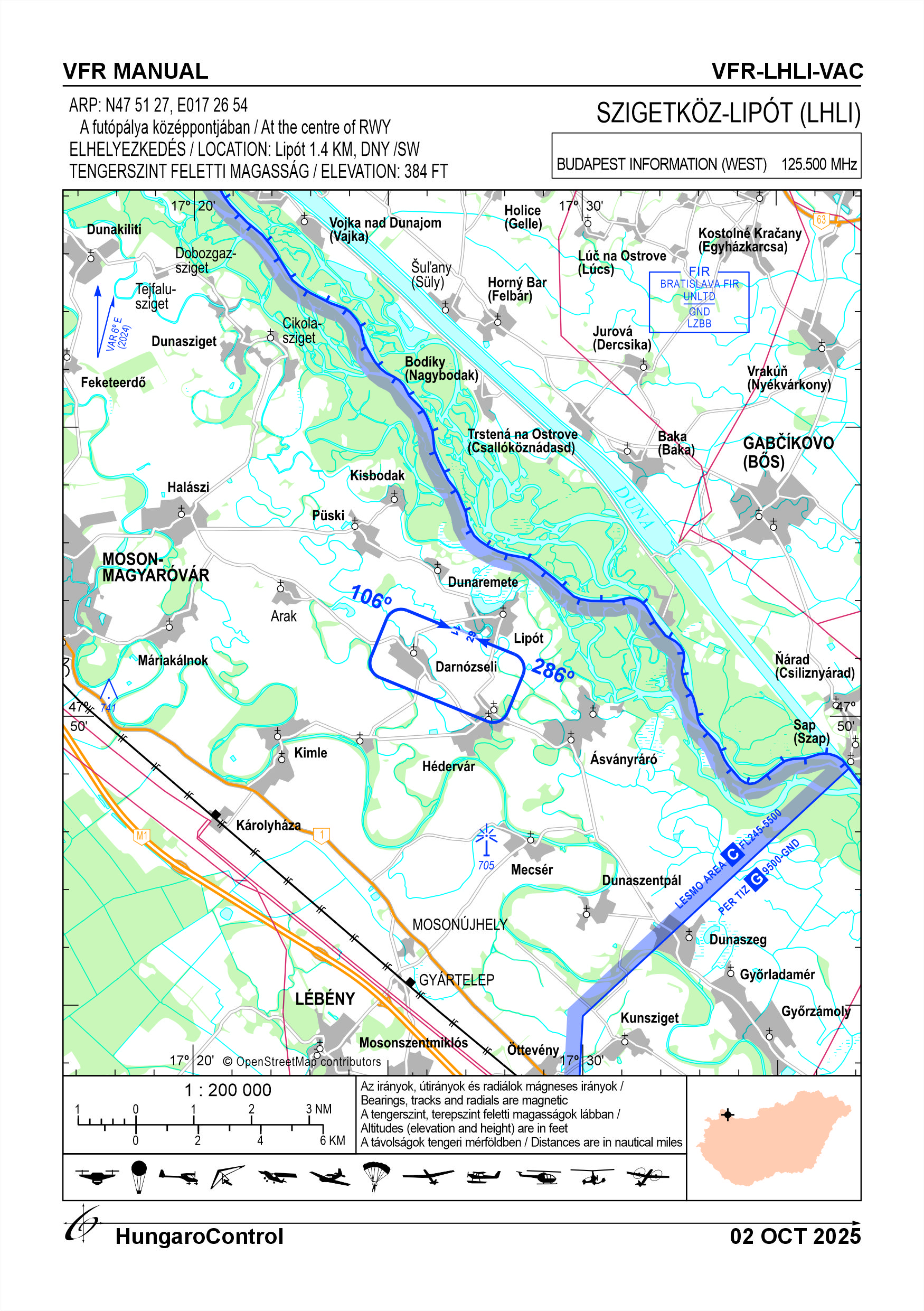
- Coordinates
- 475127N 0172654E
- Site at aerodrome
- At the centre of RWY
Location of aerodrome
- Distance from city (KM)
- Lipót 1.4 KM
- Direction from city
- SW
- Elevation
- 384 FT
Magnetic variation data
- Degree of magnetic variation ( °)
- 6° E
- Annual change ( °)
- +0.15°
- Year of survey
- 2024
Aerodrome operator data
- Name
- Turi István
- Address
- 6726 Szeged, Hátszegi utca 13.
- Phone
- +36-30/938-3129
- Fax
- NIL
- Web
- NIL
- tanker@tankerkft.hu
Aerodrome data
- Name
- 9232 Darnózseli, 05/16 hrsz.
- Phone
- +36-30/938-3129 (Turi István)
- Fax
- NIL
- Web
- NIL
- tanker@tankerkft.hu
- AFS
- NIL
- SITA
- NIL
- Others
- NIL
- Type of traffic allowed at the aerodrome
- VFR
- Remarks
- Special airport for civil use
- Responsible operator's name
- NIL
- Time logged
- NIL
6. Air traffic services communication facitlities
|
Service designation
|
Call sign
|
Channel
|
Languages used
|
Hours of operation
|
Remarks
|
|---|---|---|---|---|---|
| NIL | NIL | NIL | NIL | NIL | NIL |
7. Operation hours
- AD Administration
- The airport may be used with the prior permission of the operator (from sunrise to sunset), except for aircraft in an emergency situation
- Customs and immigration
- NIL
- Health and sanitation
- NIL
- AIS Briefing Office
- NIL
- ATS Reporting Office (ARO)
- NIL
- MET Briefing Office
- NIL
- ATS
- NIL
- Fuelling
- NIL
- Handling
- NIL
- Security
- NIL
- De-icing
- NIL
- Remarks
- The airfield can only be used with the authorisation of the owner or operator except aircrafts in emergency
8. Available handling services and facilities
- Cargo-handling facilities
- NIL
- Fuel types
- NIL
- Oil types
- NIL
- Fuelling facilities and capacity
- NIL
- De-icing facilities
- NIL
- Hangar space for visiting aircraft
- NIL
- Repair facilities for visiting aircraft
- NIL
- Remarks
- NIL
9. Passenger facilities
- Hotels
- In the village (Lipót, Darnózseli)
- Restaurants
- Buffet, restaurants in the village (Lipót, Darnózseli)
- Transportation
- Taxi
- Medical facilities
- First aid at village
- Bank and Post Office
- In the village (Lipót, Darnózseli)
- Tourist Office
- In the village (Lipót, Darnózseli)
- Remarks
- NIL
10. Available rescue and fire fighting services
- Aerodrome catogory for fire fighting
- Category 1 as defined in Annex 3 to Government Decree 85/2024 (IV.17).
- Available rescue and fire fighting services
- NIL
- Rescue and fire fighting equipment
- The quantity of fire extinguishing material required for category 1 of Annex 3 of Government Decree 85/2024 (IV. 17) and the equipment required in point 2.9 of the Decree
- Capability for removal of disabled aircraft
- 1 Tractor
- Remarks
- NIL
11. Clearing
- Types of clearing equipment
- NIL
- Clearance priorities
- NIL
- Remarks
- During the winter period, the operator will provide information on the condition of the track
12. Aprons
|
Designation
|
Surface
|
Strength
|
Remarks
|
Designator
|
|---|---|---|---|---|
| APRON | Grass | 10 t (3 t) | Only aircraft under 5.7 tonnes MTOW are allowed to use the airport, except for Air Force helicopters | NIL |
13. Taxiways
|
Designation
|
Surface
|
Strength
|
Width (M)
|
Remarks
|
Designatior
|
|---|---|---|---|---|---|
| NIL | NIL | NIL | NIL | NIL | NIL |
14. Checkpoints
Altimeter checkpoints and locations data
- Coordinates
- NIL
- Technical data
- NIL
- VOR checkpoints
- NIL
- INS checkpoints
- NIL
- Remarks
- NIL
15. Surface movement guidance and control system and markings
- Use of aircraft stand ID signs, TWY guide lines and visual docking/parking guidance system of aircraft stands
- NIL
- RWY and TWY markings and lighting
- RWY: designation, threshold
- Stop bars
- NIL
- Remarks
- NIL
16. Runways (RWY)
|
RWY designator
|
True bearing
|
Magnetic bearing
|
Length (M)
|
Width (M)
|
Strength
|
Surface
|
Remarks
|
|---|---|---|---|---|---|---|---|
| 11 | 112° | 106° | 795 | 30 | 10 t (3 t) | Grass | Only aircraft under 5.7 tonnes MTOW are allowed to use the airport, except for Air Force helicopters |
| 29 | 292° | 286° | 795 | 30 | 10 t (3 t) | Grass | Only aircraft under 5.7 tonnes MTOW are allowed to use the airport, except for Air Force helicopters |
17. Aerodrome obstacles
18. Stopways (SWY)
|
RWY designator
|
Length (M)
|
Width (M)
|
Strength
|
Surface
|
Slope (%)
|
Remarks
|
|---|---|---|---|---|---|---|
| 11 | NIL | NIL | NIL | NIL | NIL | NIL |
| 29 | NIL | NIL | NIL | NIL | NIL | NIL |
19. Clearways (CWY)
|
RWY designator
|
Length (M)
|
Width (M)
|
Slope (%)
|
Remarks
|
|---|---|---|---|---|
| 11 | NIL | NIL | NIL | NIL |
| 29 | NIL | NIL | NIL | NIL |
20. STRIP
|
RWY designator
|
Length (M)
|
Width (M)
|
Remarks
|
|---|---|---|---|
| 11 | 850 | 40 | NIL |
| 29 | 850 | 40 | NIL |
21. RESA
|
RWY designator
|
Length (M)
|
Width (M)
|
Surface
|
Obstacle free zone (OFZ)
|
Remarks
|
|---|---|---|---|---|---|
| 11 | NIL | NIL | NIL | NIL | NIL |
| 29 | NIL | NIL | NIL | NIL | NIL |
22. Declared distances
|
RWY designator
|
TORA (M)
|
TODA (M)
|
ASDA (M)
|
LDA (M)
|
Remarks
|
|---|---|---|---|---|---|
| 11 | 795 | 795 | 795 | 795 | NIL |
| 29 | 795 | 795 | 795 | 795 | NIL |
23. Approach lighting
|
RWY designator
|
Type
|
Length (M)
|
Intensity
|
Remarks
|
|---|---|---|---|---|
| 11 | NIL | NIL | NIL | NIL |
| 29 | NIL | NIL | NIL | NIL |
24. Threshold lighting
|
RWY designator
|
Colour
|
Wing bar lights
|
Remarks
|
|---|---|---|---|
| 11 | NIL | NIL | NIL |
| 29 | NIL | NIL | NIL |
25. Visual approach slope indicator system lighting
|
RWY designator
|
Type
|
Data
|
Remarks
|
|---|---|---|---|
| 11 | NIL | NIL | NIL |
| 29 | NIL | NIL | NIL |
26. Touchdone zone lighting
|
RWY designator
|
Length of lighting (M)
|
Remarks
|
|---|---|---|
| 11 | NIL | NIL |
| 29 | NIL | NIL |
27. Runway centreline lighting
|
RWY designator
|
Length (M)
|
Spacing (M)
|
Colour
|
Intensity
|
Remarks
|
|---|---|---|---|---|---|
| 11 | NIL | NIL | NIL | NIL | NIL |
| 29 | NIL | NIL | NIL | NIL | NIL |
28. Runway edgeline lighting
|
RWY designator
|
Length (M)
|
Spacing (M)
|
Colour
|
Intensity
|
Remarks
|
|---|---|---|---|---|---|
| 11 | NIL | NIL | NIL | NIL | NIL |
| 29 | NIL | NIL | NIL | NIL | NIL |
29. Runway end lighting
|
RWY designator
|
Colour
|
Remarks
|
|---|---|---|
| 11 | NIL | NIL |
| 29 | NIL | NIL |
30. Runway wing bars lighting
|
RWY designator
|
Colour
|
Remarks
|
|---|---|---|
| 11 | NIL | NIL |
| 29 | NIL | NIL |
31. Stopway lighting
|
RWY designator
|
Length of lighting (M)
|
Colour
|
Remarks
|
|---|---|---|---|
| 11 | NIL | NIL | NIL |
| 29 | NIL | NIL | NIL |
32. Other lighting, secondary power supply
- ABN/IBN location, charasteristics and hours of operation
- NIL
- LDI location and lighting
- NIL
- Anemometer location and lighting
- NIL
- 4Centre line lighting
- NIL
- TWY edge line lighting
- NIL
- Secondary power supply
- NIL
- Switch-over time
- NIL
- Remarks
- NIL
33. Helicopter landing area
- Coordinates TLOF or THR of FATO
- 475127N 0172654E
- TLOF and/or FATO elevation
- 384 FT
- TLOF and FATO area marking
- NIL
- TLOF and FATO area dimensions (M)
- NIL
- TLOF and FATO area surface
- Grass
- TLOF and FATO area strength
- NIL
- True BRG of FATO
- NIL
- MAG BRG of FATO
- NIL
- Declared distances available
- NIL
- APP and FATO lighting
- NIL
- Remarks
- Suggested landing place: ARP
34. Meteorological information provider
- Associated MET Office
- HungaroMet Magyar Meteorológiai Szolgáltató Nonprofit Zrt. (HungaroMet Zrt.), Unit of Aviation Meteorology
- Hours of service
- H24
- Office responsible for TAF preparation
- HungaroMet Magyar Meteorológiai Szolgáltató Nonprofit Zrt. (HungaroMet Zrt.), Unit of Aviation Meteorology
- Periods of validity
- NIL
- Interval of issuance
- NIL
- Type of landing forecast
- NIL
- Landing forecast interval of issuance
- NIL
- Briefing/consultation provided
- Written briefing: https://aviation.met.hu;Consultation via phone: +36-90/603-424;Consultation via e-mail: rvo@met.hu;
- Flight documentation
- Charts, abbreviated plain language text
- Language(s) used
- HU, EN
- Charts and other information available for briefing or consultation
- Charts, aerodrome reports and forecasts in EUR region, area forecasts, MET. observations and warnings in Budapest FIR
- Supplementary equipment available for providing information
- Self-briefing via aviation.met.hu
- ATS Units provided with information
- Budapest FIC (on request)
- Remarks
- NIL
35. Air traffic service airspace
- Designation
- NIL
- Lateral limits
- NIL
- Vertical limits (FT)
- NIL
- Airspace classification
- NIL
- ATS unit call sign
- NIL
- Languages used
- NIL
- Transition altitude (FT)
- NIL
- Remarks
- NIL
37. Local aerodrome regulations
The airport is open to various types of aviation (paragliding (towed and winched), SES, UL, glider, motorised, hot air balloon, parachute, balloon, paraglider, model aircraft, etc.), both separately and in combination, in accordance with local regulations. Local rules on the conduct of individual operations and cooperation between different operators: - The use of the airport and the organisation of operations at the airport are subject to the prior authorisation of the owner or operator, except for aircraft in an emergency situation. - There is no air traffic service at the airport, so access to the airport and take-offs and landings at the airport may be carried out in accordance with the relevant air traffic regulations. - Only one launch site can be set up at the airport at a time. - The operation of a parachute operation at an airport shall be subject to the following activity requirements of the activity, subject to the prior approval of the owner, in accordance with the legislation or with the consent of the owner or the operator, over the working area of the airport, active in active ad hoc airspace under the responsibility of the competent ATS unit, subject to notification and authorisation. - During the time of a parachute jump, other parachutists shall not be allowed to land on the working area of the aerodrome or in the airspace above it activities shall not be conducted. - Conduct aerobatics at the aerodrome in accordance with the requirements applicable to the activity the activity, only with the prior agreement of the owner or the the owner or operator, over the working area of the aerodrome, with the consent of the airspace, subject to the information and authorisation of the competent ATS unit. The airport is close to the state border, so the airport can only be used to enter or leave the airport. For more information, see the Airport Rules.
Activities at the airport (Yes / No)
- Unmanned aerial vehicle (D)
- Yes
- Ballon (B)
- Yes
- Ultralight (U)
- Yes
- Hang glider (N)
- Yes
- Short take-off and landing (R)
- Yes
- Landplane (L)
- Yes
- Paraglider (P)
- Yes
- Glider (G)
- Yes
- Amphibian (A)
- Yes
- Helicopter (H)
- Yes
- Gyrocopter (G)
- Yes
- Tilt-wing aircraft (T)
- Yes
- Other (O)
- NIL
38. Noise abatement procedures
In order to protect and reduce noise in residential areas, motorised and utility aircraft may use the designated school loop avoiding the residential areas. To derogate from this (e.g. in the case of pedestrian flights over built-up areas, etc.) only in the case of flights over populated areas In the case of overflights (e.g. in the case of overflights of airfields), the rules for the implementation of the emergency services, HM, BM, water authorities, etc. must be observed, special agricultural, disaster management flights. Additional noise abatement regulations restricting airport traffic: - no jet aircraft are allowed to use the airport, - no night flights are allowed. No motorised aircraft may be launched or propelled within the distance of buildings and other obstacles. the appropriate safety distance from obstacles and for the required duration.
39. Aerodrome charges
NIL
40. Additional information
Warning: LHB21 Bird migration and area with sensitive fauna south from AD.For more information, see the Airport Rules.
41. Aerodrome obstacles
- No obstacle text
- NIL
- RWY designator
- NIL
- Obstacle type
- NIL
- Elevation
- NIL
- Height
- NIL
- Coordinates
- NIL
- Remarks
- NIL