LHKV Kaposújlak Airport
Last updated: 2025.06.12.
1. Aerodrome identification
- Aerodrome location indicator
- LHKV
- Aerodrome name
- Kaposújlak Airport
- Aerodrome place name
- Kaposújlak
2. Contact
- Address
- 7522 Kaposújlak, Repülőtér
- Phone
- +36-82/511-038
- info@aviarent.hu
3. Gallery
Teljes képernyő
Teljes
képernyő bezárása

Teljes képernyő
Teljes
képernyő bezárása
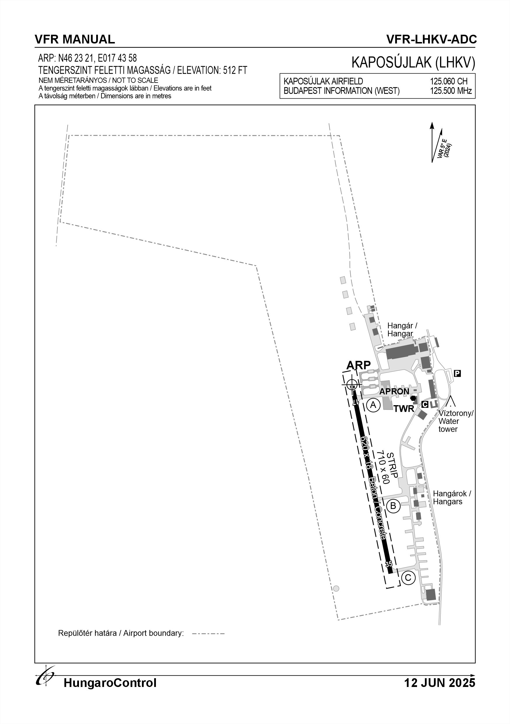
5. Aerodrome geographical and administrative data
ARP data
- Coordinates
- 462321N 0174358E
- Site at aerodrome
- At the THR 17
Location of aerodrome
- Distance from city (KM)
- Kaposújlak 600 M
- Direction from city
- 310°
- Elevation
- 512 FT
Magnetic variation data
- Degree of magnetic variation ( °)
- 5°22' E
- Annual change ( °)
- +0°08'
- Year of survey
- 2024
Aerodrome operator data
- Name
- AVIA-Rent Kft.
- Address
- 1118 Budapest, Rétköz utca 4.
- Phone
- +36-82/511-038
- Fax
- +36-82/511-039
- Web
- NIL
- info@aviarent.hu
Aerodrome data
- Name
- 7522 Kaposújlak, Repülőtér
- Phone
- +36-20/358-7779 (Kornyik Csaba Mihály)
- Fax
- NIL
- Web
- NIL
- info@aviarent.hu
- AFS
- NIL
- SITA
- NIL
- Others
- NIL
- Type of traffic allowed at the aerodrome
- VFR, NVFR
- Remarks
- Special airport for civil use
- Responsible operator's name
- NIL
- Time logged
- NIL
6. Air traffic services communication facitlities
|
Service designation
|
Call sign
|
Channel
|
Languages used
|
Hours of operation
|
Remarks
|
|---|---|---|---|---|---|
| NIL | Kaposújlak Repülőtér | 125.060 CH | HU, EN | NIL | In case of active Drop Zone |
7. Operation hours
- AD Administration
- From the beginning of the morning twilight period until the end of the evening twilight period (according to Part-SERA Article 2, point 97), in conditions suitable for VFR flight, except NVFR, shall be open on snow-free days subject to the prior permission/consent of the Operator.
- Customs and immigration
- NIL
- Health and sanitation
- NIL
- AIS Briefing Office
- NIL
- ATS Reporting Office (ARO)
- NIL
- MET Briefing Office
- NIL
- ATS
- NIL
- Fuelling
- NIL
- Handling
- NIL
- Security
- Fences on all sides, security cameras
- De-icing
- NIL
- Remarks
- Prior permission required, 24 hours
8. Available handling services and facilities
- Cargo-handling facilities
- NIL
- Fuel types
- NIL
- Oil types
- NIL
- Fuelling facilities and capacity
- NIL
- De-icing facilities
- NIL
- Hangar space for visiting aircraft
- NIL
- Repair facilities for visiting aircraft
- Repair and maintenance with the prior agreement of the airport operator
- Remarks
- NIL
9. Passenger facilities
- Hotels
- In the city of Kaposvár
- Restaurants
- In the city of Kaposvár
- Transportation
- Taxi
- Medical facilities
- First aid
- Bank and Post Office
- In the city of Kaposvár
- Tourist Office
- NIL
- Remarks
- NIL
10. Available rescue and fire fighting services
- Aerodrome catogory for fire fighting
- Categories 1, 2 as defined in Annex 3 to Government Decree 85/2024 (IV.17) depending on the activity actually being carried out
- Available rescue and fire fighting services
- 1 person with a fire safety qualification
- Rescue and fire fighting equipment
- Fire extinguishers and equipment in category 1 and 2 of Annex 3 of Government Decree 85/2024 (IV.17), and 1 vehicle
- Capability for removal of disabled aircraft
- NIL
- Remarks
- Category 2 for economic operations, otherwise category 1. Only organisations authorised in writing may carry out economic activities.
11. Clearing
- Types of clearing equipment
- NIL
- Clearance priorities
- NIL
- Remarks
- NIL
12. Aprons
|
Designation
|
Surface
|
Strength
|
Remarks
|
Designator
|
|---|---|---|---|---|
| APR | Concrete, Asphalt | 20 t | NIL | NIL |
13. Taxiways
|
Designation
|
Surface
|
Strength
|
Width (M)
|
Remarks
|
Designatior
|
|---|---|---|---|---|---|
| TWY A | Concrete | 20 t | 10 | NIL | NIL |
| TWY B | Concrete | 20 t | 10 | NIL | NIL |
| TWY C | Concrete | 20 t | 10 | NIL | NIL |
14. Checkpoints
Altimeter checkpoints and locations data
- Coordinates
- NIL
- Technical data
- NIL
- VOR checkpoints
- NIL
- INS checkpoints
- NIL
- Remarks
- NIL
15. Surface movement guidance and control system and markings
- Use of aircraft stand ID signs, TWY guide lines and visual docking/parking guidance system of aircraft stands
- NIL
- RWY and TWY markings and lighting
- Threshold and pavement signs, edge lights
- Stop bars
- NIL
- Remarks
- NIL
16. Runways (RWY)
|
RWY designator
|
True bearing
|
Magnetic bearing
|
Length (M)
|
Width (M)
|
Strength
|
Surface
|
Remarks
|
|---|---|---|---|---|---|---|---|
| 17 | 166° | 161° | 620 | 18 | 20 t | Concrete | NIL |
| 35 | 346° | 341° | 620 | 18 | 20 t | Concrete | NIL |
17. Aerodrome obstacles
|
RWY designator
|
Obstacle type
|
Elevation
|
Height
|
Coordinates
|
Remarks
|
|---|---|---|---|---|---|
| 17 | Antenna | 561 FT | 49 FT | NIL | NIL |
| 17 | Antenna | 561 FT | 49 FT | NIL | NIL |
| 17 | Water tower | 561 FT | 49 FT | NIL | NIL |
18. Stopways (SWY)
|
RWY designator
|
Length (M)
|
Width (M)
|
Strength
|
Surface
|
Slope (%)
|
Remarks
|
|---|---|---|---|---|---|---|
| 17 | NIL | NIL | NIL | NIL | NIL | NIL |
| 35 | NIL | NIL | NIL | NIL | NIL | NIL |
19. Clearways (CWY)
|
RWY designator
|
Length (M)
|
Width (M)
|
Slope (%)
|
Remarks
|
|---|---|---|---|---|
| 17 | NIL | NIL | NIL | NIL |
| 35 | NIL | NIL | NIL | NIL |
20. STRIP
|
RWY designator
|
Length (M)
|
Width (M)
|
Remarks
|
|---|---|---|---|
| 17 | 710 | 60 | NIL |
| 35 | 710 | 60 | NIL |
21. RESA
|
RWY designator
|
Length (M)
|
Width (M)
|
Surface
|
Obstacle free zone (OFZ)
|
Remarks
|
|---|---|---|---|---|---|
| 17 | NIL | NIL | NIL | NIL | NIL |
| 35 | NIL | NIL | NIL | NIL | NIL |
22. Declared distances
|
RWY designator
|
TORA (M)
|
TODA (M)
|
ASDA (M)
|
LDA (M)
|
Remarks
|
|---|---|---|---|---|---|
| 17 | 620 | 620 | 620 | 620 | NIL |
| 35 | 620 | 620 | 620 | 620 | NIL |
23. Approach lighting
|
RWY designator
|
Type
|
Length (M)
|
Intensity
|
Remarks
|
|---|---|---|---|---|
| 17 | NIL | NIL | NIL | NIL |
| 35 | NIL | NIL | NIL | NIL |
24. Threshold lighting
|
RWY designator
|
Colour
|
Wing bar lights
|
Remarks
|
|---|---|---|---|
| 17 | NIL | NIL | NIL |
| 35 | NIL | NIL | NIL |
25. Visual approach slope indicator system lighting
|
RWY designator
|
Type
|
Data
|
Remarks
|
|---|---|---|---|
| 17 | NIL | NIL | NIL |
| 35 | NIL | NIL | NIL |
26. Touchdone zone lighting
|
RWY designator
|
Length of lighting (M)
|
Remarks
|
|---|---|---|
| 17 | NIL | NIL |
| 35 | NIL | NIL |
27. Runway centreline lighting
|
RWY designator
|
Length (M)
|
Spacing (M)
|
Colour
|
Intensity
|
Remarks
|
|---|---|---|---|---|---|
| 17 | NIL | NIL | NIL | NIL | NIL |
| 35 | NIL | NIL | NIL | NIL | NIL |
28. Runway edgeline lighting
|
RWY designator
|
Length (M)
|
Spacing (M)
|
Colour
|
Intensity
|
Remarks
|
|---|---|---|---|---|---|
| 17 | 620 | 40 | White | NIL | NIL |
| 35 | 620 | 40 | White | NIL | NIL |
29. Runway end lighting
|
RWY designator
|
Colour
|
Remarks
|
|---|---|---|
| 17 | NIL | NIL |
| 35 | NIL | NIL |
30. Runway wing bars lighting
|
RWY designator
|
Colour
|
Remarks
|
|---|---|---|
| 17 | NIL | NIL |
| 35 | NIL | NIL |
31. Stopway lighting
|
RWY designator
|
Length of lighting (M)
|
Colour
|
Remarks
|
|---|---|---|---|
| 17 | NIL | NIL | NIL |
| 35 | NIL | NIL | NIL |
32. Other lighting, secondary power supply
- ABN/IBN location, charasteristics and hours of operation
- NIL
- LDI location and lighting
- NIL
- Anemometer location and lighting
- Tower
- 4Centre line lighting
- NIL
- TWY edge line lighting
- NIL
- Secondary power supply
- Generator, Cyber Power VALUE 1500 E-B, 100 minute duration
- Switch-over time
- NIL
- Remarks
- NIL
33. Helicopter landing area
- Coordinates TLOF or THR of FATO
- NIL
- TLOF and/or FATO elevation
- NIL
- TLOF and FATO area marking
- NIL
- TLOF and FATO area dimensions (M)
- NIL
- TLOF and FATO area surface
- NIL
- TLOF and FATO area strength
- NIL
- True BRG of FATO
- NIL
- MAG BRG of FATO
- NIL
- Declared distances available
- NIL
- APP and FATO lighting
- NIL
- Remarks
- NIL
34. Meteorological information provider
- Associated MET Office
- HungaroMet Magyar Meteorológiai Szolgáltató Nonprofit Zrt. (HungaroMet Zrt.), Unit of Aviation Meteorology
- Hours of service
- H24
- Office responsible for TAF preparation
- HungaroMet Magyar Meteorológiai Szolgáltató Nonprofit Zrt. (HungaroMet Zrt.), Unit of Aviation Meteorology
- Periods of validity
- NIL
- Interval of issuance
- NIL
- Type of landing forecast
- NIL
- Landing forecast interval of issuance
- NIL
- Briefing/consultation provided
- Written briefing: https://aviation.met.hu;Consultation via phone: +36-90/603-424;Consultation via e-mail: rvo@met.hu;
- Flight documentation
- Charts, abbreviated plain language text
- Language(s) used
- HU, EN
- Charts and other information available for briefing or consultation
- Charts, aerodrome reports and forecasts in EUR region, area forecasts, MET. observations and warnings in Budapest FIR
- Supplementary equipment available for providing information
- Self-briefing via aviation.met.hu
- ATS Units provided with information
- Budapest FIC (on request)
- Remarks
- NIL
35. Air traffic service airspace
- Designation
- LHSDZLHKV / KAPOSÚJLAK DROP ZONE
- Lateral limits
- 463100N 0173400E - 463100N 0174700E - 461800N 0174700E - 461800N 0173400E - 463100N 0173400E
- Vertical limits (FT)
- GND - FL165
- Airspace classification
- NIL
- ATS unit call sign
- Kaposújlak Repülőtér
- Languages used
- HU, EN
- Transition altitude (FT)
- 10 000 FT
- Remarks
- Prior coordination required if DropZone is active
37. Local aerodrome regulations
The airport is a special airport for civil use not open to public traffic according to Section 37 (1) of the Aviation Act (Act), which, except in the cases specified in paragraphs (6) to (7) of Article 41, may be used on the basis of the operator's permit. Traffic circles may be used in both directions, with a height of 1000 FT AGL. RWY 35: left traffic circle after take-off from turn 2 with continuous climb. RWY 17: after take-off, right traffic circle from turn 2 with continuous climb. Aircraft may be diverted from the traffic circle to airspace or en-route from both traffic circles of runway 17/35. In the case of an active Drop Zone, overflights, landings or take-offs are only permitted with the agreement of the coordinating organisation and only if bilateral radio contact is established. The commander of any aircraft at the aerodrome outside the Drop Zone shall be responsible for timing engine start-up, warm-up, taxiing and stall in the case of inbound aircraft so that the aircraft is not in the airspace and the engine is not in stall when performing a parachute jump. For more information, see the Airport Rules.
Activities at the airport (Yes / No)
- Unmanned aerial vehicle (D)
- Yes
- Ballon (B)
- Yes
- Ultralight (U)
- Yes
- Hang glider (N)
- Yes
- Short take-off and landing (R)
- Yes
- Landplane (L)
- Yes
- Paraglider (P)
- Yes
- Glider (G)
- Yes
- Amphibian (A)
- No
- Helicopter (H)
- Yes
- Gyrocopter (G)
- Yes
- Tilt-wing aircraft (T)
- Yes
- Other (O)
- Any kind of flying activities are allowed upon previous coordination
38. Noise abatement procedures
It is prohibited to fly motorized aircraft over 300 m above surrounding residential areas below 1000 ft AGL, except for takeoff and landing. Takeoffs after climbing in the traffic circle must be made avoiding residential areas. Compared to the standard noise exposure for aircraft movements in the air, ground operations other than runway operations have a significantly lower noise exposure level. Maintenance and pre-flight engine tests may be performed on the apron.
39. Aerodrome charges
By prior agreement.
40. Additional information
For more information, see the Airport Rules.
41. Aerodrome obstacles
- No obstacle text
- NIL
- RWY designator
- NIL
- Obstacle type
- NIL
- Elevation
- NIL
- Height
- NIL
- Coordinates
- NIL
- Remarks
- NIL