LHKD Kecskéd Airport
Last updated: 2026.10.01.
1. Aerodrome identification
- Aerodrome location indicator
- LHKD
- Aerodrome name
- Kecskéd Airport
- Aerodrome place name
- Kecskéd
2. Contact
- Address
- 2852 Kecskéd, 06. hrsz.
- Phone
- +36-20/582-4410 (Nánai Tibor), +36-30/972-2261
- repulotervezeto@lhkd.hu
3. Gallery
Teljes képernyő
Teljes
képernyő bezárása

Teljes képernyő
Teljes
képernyő bezárása

Teljes képernyő
Teljes
képernyő bezárása
Teljes képernyő
Teljes
képernyő bezárása
5. Aerodrome geographical and administrative data
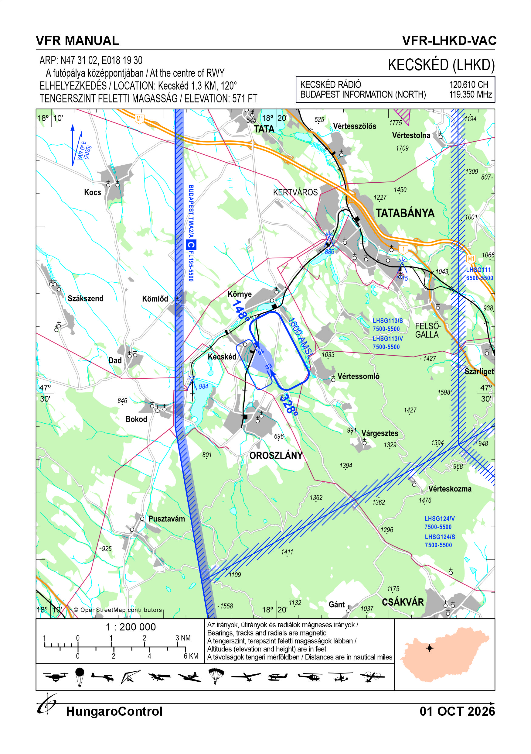
ARP data
- Coordinates
- 473102N 0181930E
- Site at aerodrome
- At the centre of RWY
Location of aerodrome
- Distance from city (KM)
- Kecskéd 1.3 KM
- Direction from city
- 120°
- Elevation
- 571 FT
Magnetic variation data
- Degree of magnetic variation ( °)
- 5°40' E
- Annual change ( °)
- +0°06'
- Year of survey
- 2026
Aerodrome operator data
- Name
- Aeroklub Kecskéd
- Address
- 2852 Kecskéd, 06. hrsz., Posta: 2841 Oroszlány, Pf. 146.
- Phone
- +36-20/582-4410 (Nánai Tibor), +36-30/972-2261
- Fax
- NIL
- Web
- https://lhkd.hu/
- repulotervezeto@lhkd.hu
Aerodrome data
- Name
- 2852 Kecskéd, 06. hrsz.
- Phone
- +36-20/582-4410 (Nánai Tibor)
- Fax
- NIL
- Web
- https://lhkd.hu/
- repulotervezeto@lhkd.hu
- AFS
- NIL
- SITA
- NIL
- Others
- NIL
- Type of traffic allowed at the aerodrome
- VFR
- Remarks
- Special airport for civil use
- Name of responsible manager
- Nánai Tibor
- Hours of service
- Az üzembentartó által szervezett, vagy alkalmanként engedélyezett repülő üzem.
6. Air traffic services communication facitlities
|
Service designation
|
Call sign
|
Channel
|
Languages used
|
Hours of operation
|
Remarks
|
|---|---|---|---|---|---|
| Kecskéd Rádió | Kecskéd Rádió | 120.610 CH | HU | Under organised service | NIL |
7. Operation hours
- AD Administration
- From sunrise to sunset, in weather suitable for VFR flights. The airport is only open on days when there is no snow.
- Customs and immigration
- NIL
- Health and sanitation
- NIL
- AIS Briefing Office
- NIL
- ATS Reporting Office (ARO)
- NIL
- MET Briefing Office
- NIL
- ATS
- NIL
- Fuelling
- NIL
- Handling
- NIL
- Security
- Area monitored by camera. Outgoing guard service in case of an alarm.
- De-icing
- NIL
- Remarks
- NIL
8. Available handling services and facilities
- Cargo-handling facilities
- NIL
- Fuel types
- NIL
- Oil types
- NIL
- Fuelling facilities and capacity
- NIL
- De-icing facilities
- NIL
- Hangar space for visiting aircraft
- By prior arrangement outdoors or according to hangar occupancy.
- Repair facilities for visiting aircraft
- NIL
- Remarks
- NIL
9. Passenger facilities
- Hotels
- NIL
- Restaurants
- NIL
- Transportation
- NIL
- Medical facilities
- NIL
- Bank and Post Office
- NIL
- Tourist Office
- NIL
- Remarks
- NIL
10. Available rescue and fire fighting services
- Aerodrome catogory for fire fighting
- Category 1 as defined in Annex 3 to Government Decree 85/2024 (IV.17). Occasionally category 2 and up to category 3 depending on the activity.
- Available rescue and fire fighting services
- At least 1 volunteer firefighter with a firefighting certificate or a fire safety certificate. Service corresponding to the actual category.
- Rescue and fire fighting equipment
- Ffire-fighting tools and equipment complying with the classification.
- Capability for removal of disabled aircraft
- According to the operator's alert plan. Gróf Transz Kft. provides its contracted partners with specialised cranes and transport equipment, in accordance with the contract.
- Remarks
- NIL
11. Clearing
- Types of clearing equipment
- NIL
- Clearance priorities
- NIL
- Remarks
- The airport is only open on days when there is no snow
12. Aprons
|
Designation
|
Surface
|
Strength
|
Remarks
|
Designator
|
|---|---|---|---|---|
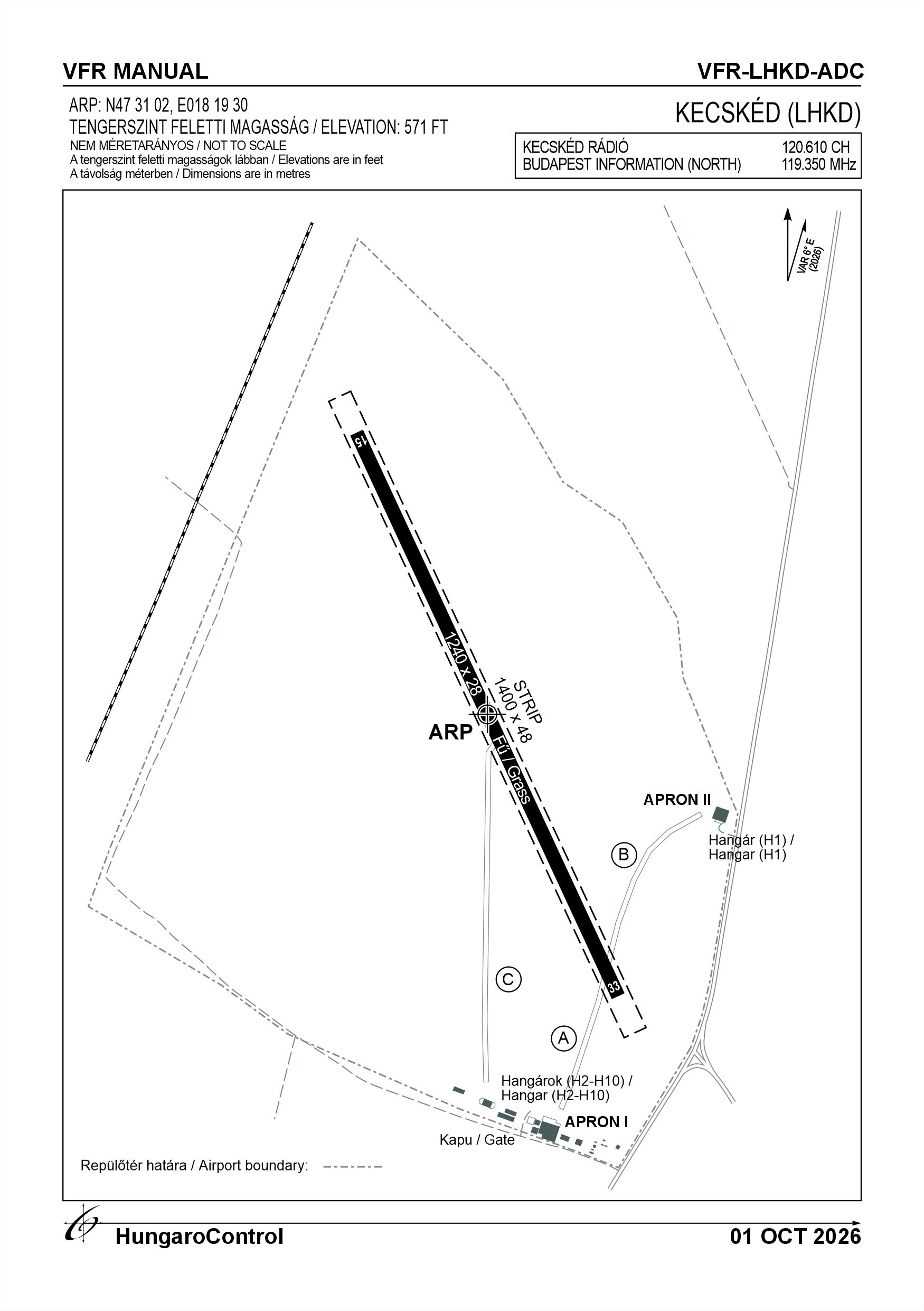
| I | Concrete and grass | 5.7 t | Painted | NIL |
| II | Concrete and grass | 4 t | Areas marked with signs | NIL |
13. Taxiways
|
Designation
|
Surface
|
Strength
|
Width (M)
|
Remarks
|
Designatior
|
|---|---|---|---|---|---|
| A | Grass | 5.7 t | 15 M | Identification: new hangar | NIL |
| B | Grass | 5.7 t | 10 M | Identification: old hangar | NIL |
| C | Grass | 5.7 t | 15 M | Identification: center | NIL |
14. Checkpoints
Altimeter checkpoints and locations data
- Coordinates
- NIL
- Technical data
- NIL
- VOR checkpoints
- NIL
- INS checkpoints
- NIL
- Remarks
- NIL
15. Surface movement guidance and control system and markings
- Use of aircraft stand ID signs, TWY guide lines and visual docking/parking guidance system of aircraft stands
- NIL
- RWY and TWY markings and lighting
- RWY, TWY threshold and direction markings, edge markings without lighting
- Stop bars
- NIL
- Remarks
- NIL
16. Runways (RWY)
|
RWY designator
|
True bearing
|
Magnetic bearing
|
Length (M)
|
Width (M)
|
Strength
|
Surface
|
Remarks
|
|---|---|---|---|---|---|---|---|
| 15 | 154° | 148° | 1240 | 28 | 5.7 t (3 t) | Grass | Designated for motorised traffic |
| 33 | 334° | 328° | 1240 | 28 | 5.7 t (3 t) | Grass | Designated for motorised traffic |
17. Aerodrome obstacles
18. Stopways (SWY)
|
RWY designator
|
Length (M)
|
Width (M)
|
Strength
|
Surface
|
Slope (%)
|
Remarks
|
|---|---|---|---|---|---|---|
| 15 | NIL | NIL | NIL | NIL | NIL | NIL |
| 33 | NIL | NIL | NIL | NIL | NIL | NIL |
19. Clearways (CWY)
|
RWY designator
|
Length (M)
|
Width (M)
|
Slope (%)
|
Remarks
|
|---|---|---|---|---|
| 15 | NIL | NIL | NIL | NIL |
| 33 | NIL | NIL | NIL | NIL |
20. STRIP
|
RWY designator
|
Length (M)
|
Width (M)
|
Remarks
|
|---|---|---|---|
| 15 | 1400 | 48 | Grass |
| 33 | 1400 | 48 | Grass |
21. RESA
|
RWY designator
|
Length (M)
|
Width (M)
|
Surface
|
Obstacle free zone (OFZ)
|
Remarks
|
|---|---|---|---|---|---|
| 15 | NIL | NIL | NIL | NIL | NIL |
| 33 | NIL | NIL | NIL | NIL | NIL |
22. Declared distances
|
RWY designator
|
TORA (M)
|
TODA (M)
|
ASDA (M)
|
LDA (M)
|
Remarks
|
|---|---|---|---|---|---|
| 15 | 1240 | 1240 | 1240 | 1240 | NIL |
| 33 | 1240 | 1240 | 1240 | 1240 | NIL |
23. Approach lighting
|
RWY designator
|
Type
|
Length (M)
|
Intensity
|
Remarks
|
|---|---|---|---|---|
| 15 | NIL | NIL | NIL | NIL |
| 33 | NIL | NIL | NIL | NIL |
24. Threshold lighting
|
RWY designator
|
Colour
|
Wing bar lights
|
Remarks
|
|---|---|---|---|
| 15 | NIL | NIL | NIL |
| 33 | NIL | NIL | NIL |
25. Visual approach slope indicator system lighting
|
RWY designator
|
Type
|
Data
|
Remarks
|
|---|---|---|---|
| 15 | NIL | NIL | NIL |
| 33 | NIL | NIL | NIL |
26. Touchdone zone lighting
|
RWY designator
|
Length of lighting (M)
|
Remarks
|
|---|---|---|
| 15 | NIL | NIL |
| 33 | NIL | NIL |
27. Runway centreline lighting
|
RWY designator
|
Length (M)
|
Spacing (M)
|
Colour
|
Intensity
|
Remarks
|
|---|---|---|---|---|---|
| 15 | NIL | NIL | NIL | NIL | NIL |
| 33 | NIL | NIL | NIL | NIL | NIL |
28. Runway edgeline lighting
|
RWY designator
|
Length (M)
|
Spacing (M)
|
Colour
|
Intensity
|
Remarks
|
|---|---|---|---|---|---|
| 15 | NIL | NIL | NIL | NIL | NIL |
| 33 | NIL | NIL | NIL | NIL | NIL |
29. Runway end lighting
|
RWY designator
|
Colour
|
Remarks
|
|---|---|---|
| 15 | NIL | NIL |
| 33 | NIL | NIL |
30. Runway wing bars lighting
|
RWY designator
|
Colour
|
Remarks
|
|---|---|---|
| 15 | NIL | NIL |
| 33 | NIL | NIL |
31. Stopway lighting
|
RWY designator
|
Length of lighting (M)
|
Colour
|
Remarks
|
|---|---|---|---|
| 15 | NIL | NIL | NIL |
| 33 | NIL | NIL | NIL |
32. Other lighting, secondary power supply
- ABN/IBN location, charasteristics and hours of operation
- NIL
- LDI location and lighting
-
1. New hangar, 20 metres north. No lighting
2. 200 metres at 60 degrees from the centre of the runway. No lighting.
- Anemometer location and lighting
- On a lamppost next to a wooden house. No lighting.
- 4Centre line lighting
- NIL
- TWY edge line lighting
- NIL
- Secondary power supply
- NIL
- Switch-over time
- NIL
- Remarks
- NIL
33. Helicopter landing area
- Coordinates TLOF or THR of FATO
- NIL
- TLOF and/or FATO elevation
- NIL
- TLOF and FATO area marking
- NIL
- TLOF and FATO area dimensions (M)
- NIL
- TLOF and FATO area surface
- NIL
- TLOF and FATO area strength
- NIL
- True BRG of FATO
- NIL
- MAG BRG of FATO
- NIL
- Declared distances available
- NIL
- APP and FATO lighting
- NIL
- Remarks
- NIL
34. Meteorological information provider
- Associated MET Office
- HungaroMet Magyar Meteorológiai Szolgáltató Nonprofit Zrt. (HungaroMet Zrt.), Unit of Aviation Meteorology
- Hours of service
- H24
- Office responsible for TAF preparation
- HungaroMet Magyar Meteorológiai Szolgáltató Nonprofit Zrt. (HungaroMet Zrt.), Unit of Aviation Meteorology
- Periods of validity
- NIL
- Interval of issuance
- NIL
- Type of landing forecast
- Forecast, LHPR, LHPA, LHBP Metar, TAF
- Landing forecast interval of issuance
- NIL
- Briefing/consultation provided
- Written briefing: https://aviation.met.hu;Consultation via phone: +36-90/603-424;Consultation via e-mail: rvo@met.hu;
- Flight documentation
- Charts, abbreviated plain language text
- Language(s) used
- HU, EN
- Charts and other information available for briefing or consultation
- Charts, aerodrome reports and forecasts in EUR region, area forecasts, MET. observations and warnings in Budapest FIR
- Supplementary equipment available for providing information
- Self-briefing via aviation.met.hu
- ATS Units provided with information
- Budapest FIC (on request)
- Remarks
- NIL
35. Air traffic service airspace
- Designation
- NIL
- Lateral limits
- NIL
- Vertical limits (FT)
- NIL
- Airspace classification
- NIL
- ATS unit call sign
- NIL
- Languages used
- NIL
- Transition altitude (FT)
- NIL
- Remarks
- NIL
37. Local aerodrome regulations
The runway and operational area may only be used, and aircraft may only take off and land on them, by designated members of natural persons or other organisations authorised by the operator or the airport’s managing director, except in the case of an emergency landing. Only those persons who have familiarised themselves with and accepted the rules set out in the airport regulations, and have confirmed this with their signature, may take off from the runway.
The day-to-day operations are organised by the airport operator, depending on the weather and flight operations.
The runway may only be used by aircraft whose captain has received permission to do so from the operator or the airport manager.
The runway may only be used by motorised aircraft in accordance with the traffic patterns, with the exception of non-motorised aircraft taking off under motorised tow.
Non-powered aircraft:
Gliders launched by towing may take off from and land at the designated launch area 100 m west of the runway, in the direction of Runway 33-15.
The traffic patterns of gliders must not coincide with those of powered aircraft. Separation shall be maintained in accordance with the rules governing traffic patterns.
Procedure for the removal of immobilised aircraft:
An immobilised aircraft must be removed from the runway as soon as possible; the aircraft commander is responsible for ensuring this. In the event of a damaged aircraft, the flight safety service must be notified. The rules regarding the securing of the scene must be observed. The scene may only be altered to the extent necessary to avert a life-threatening or immediate emergency. In such cases, the original condition must be documented by means of markings and photographs. Airport staff must cooperate in providing assistance. Proceed in accordance with the emergency plan, as appropriate to the severity of the incident.
Daytime VFR flights are permitted at the airport in accordance with the airport regulations.
Further information can be found in the Airport Rules.
The day-to-day operations are organised by the airport operator, depending on the weather and flight operations.
The runway may only be used by aircraft whose captain has received permission to do so from the operator or the airport manager.
The runway may only be used by motorised aircraft in accordance with the traffic patterns, with the exception of non-motorised aircraft taking off under motorised tow.
Non-powered aircraft:
Gliders launched by towing may take off from and land at the designated launch area 100 m west of the runway, in the direction of Runway 33-15.
The traffic patterns of gliders must not coincide with those of powered aircraft. Separation shall be maintained in accordance with the rules governing traffic patterns.
Procedure for the removal of immobilised aircraft:
An immobilised aircraft must be removed from the runway as soon as possible; the aircraft commander is responsible for ensuring this. In the event of a damaged aircraft, the flight safety service must be notified. The rules regarding the securing of the scene must be observed. The scene may only be altered to the extent necessary to avert a life-threatening or immediate emergency. In such cases, the original condition must be documented by means of markings and photographs. Airport staff must cooperate in providing assistance. Proceed in accordance with the emergency plan, as appropriate to the severity of the incident.
Daytime VFR flights are permitted at the airport in accordance with the airport regulations.
Further information can be found in the Airport Rules.
Activities at the airport (Yes / No)
- Unmanned aerial vehicle (D)
- Yes
- Ballon (B)
- Yes
- Ultralight (U)
- Yes
- Hang glider (N)
- Yes
- Short take-off and landing (R)
- Yes
- Landplane (L)
- Yes
- Paraglider (P)
- Yes
- Glider (G)
- Yes
- Amphibian (A)
- Yes
- Helicopter (H)
- Yes
- Gyrocopter (G)
- Yes
- Tilt-wing aircraft (T)
- Yes
- Other (O)
- Yes
38. Noise abatement procedures
When using Runway 33, a slight right turn must be made after reaching 50 metres in order to reduce noise pollution in residential areas.
During take-off, the full length of the runway must be used to gain as much altitude as possible.
Once at a safe altitude, it is recommended to apply the power reduction permitted by the aircraft’s flight operations manual in order to reduce noise pollution.
The traffic patterns contain further noise reduction procedures.
Engine start-up and running whilst on the ground may take place in the designated areas in front of the hangars. To minimise noise pollution, engine running and warm-up must be limited to the time strictly necessary.
Further information can be found in the Airport Rules.
During take-off, the full length of the runway must be used to gain as much altitude as possible.
Once at a safe altitude, it is recommended to apply the power reduction permitted by the aircraft’s flight operations manual in order to reduce noise pollution.
The traffic patterns contain further noise reduction procedures.
Engine start-up and running whilst on the ground may take place in the designated areas in front of the hangars. To minimise noise pollution, engine running and warm-up must be limited to the time strictly necessary.
Further information can be found in the Airport Rules.
39. Aerodrome charges
NIL
40. Additional information
For more information, see the Airport Rules.
41. Aerodrome obstacles
- No obstacle text
- NIL
- RWY designator
- NIL
- Obstacle type
- NIL
- Elevation
- NIL
- Height
- NIL
- Coordinates
- NIL
- Remarks
- NIL