LHHH Hármashatár-hegy Airport
Last updated: 2025.03.20.
1. Aerodrome identification
- Aerodrome location indicator
- LHHH
- Aerodrome name
- Hármashatár-hegy Airport
- Aerodrome place name
- Budapest
2. Contact
- Address
- 1028 Budapest, Hrsz: 015980/16
- Phone
- +36-70/523-6010
- info@hhhse.hu
3. Gallery
Teljes képernyő
Teljes
képernyő bezárása

Teljes képernyő
Teljes
képernyő bezárása
5. Aerodrome geographical and administrative data
ARP data
- Coordinates
- 473309N 0185824E
- Site at aerodrome
- Next to the RWY
Location of aerodrome
- Distance from city (KM)
- Budapest II. ker., Pesthidegkút 1 KM
- Direction from city
- 144°
- Elevation
- 902 FT
Magnetic variation data
- Degree of magnetic variation ( °)
- 5°42' E
- Annual change ( °)
- +0°09'
- Year of survey
- 2024
Aerodrome operator data
- Name
- Hármashatárhegyi Sportrepülő Egyesület
- Address
- 1028 Budapest, Hrsz: 015980/16
- Phone
- +36-70/523-6010
- Fax
- NIL
- info@hhhse.hu
Aerodrome data
- Name
- 1028 Budapest, Hrsz: 015980/16
- Phone
- +36-70/523-6010 (Máté Gábor)
- Fax
- NIL
- Web
- http://lhhh.hu/
- info@hhhse.hu
- AFS
- NIL
- SITA
- NIL
- Others
- NIL
- Type of traffic allowed at the aerodrome
- VFR
- Remarks
- Special airport for civil use
- Responsible operator's name
- NIL
- Time logged
- NIL
6. Air traffic services communication facitlities
|
Service designation
|
Call sign
|
Channel
|
Languages used
|
Hours of operation
|
Remarks
|
|---|---|---|---|---|---|
| NIL | NIL | NIL | NIL | NIL | NIL |
7. Operation hours
- AD Administration
- SR-30 minutes to SS+45 minutes, based on a permission obtained from operator at least 2 hours before use, VMC conditions
- Customs and immigration
- NIL
- Health and sanitation
- NIL
- AIS Briefing Office
- NIL
- ATS Reporting Office (ARO)
- NIL
- MET Briefing Office
- NIL
- ATS
- NIL
- Fuelling
- NIL
- Handling
- NIL
- Security
- NIL
- De-icing
- NIL
- Remarks
- NIL
8. Available handling services and facilities
- Cargo-handling facilities
- NIL
- Fuel types
- NIL
- Oil types
- NIL
- Fuelling facilities and capacity
- NIL
- De-icing facilities
- NIL
- Hangar space for visiting aircraft
- By prior arrangement
- Repair facilities for visiting aircraft
- By prior arrangement
- Remarks
- NIL
9. Passenger facilities
- Hotels
- In the city
- Restaurants
- In the city
- Transportation
- Public transportation, Taxi
- Medical facilities
- In the city
- Bank and Post Office
- In the city
- Tourist Office
- In the city
- Remarks
- NIL
10. Available rescue and fire fighting services
- Aerodrome catogory for fire fighting
- Category 2 as defined in Annex 3 to Government Decree 85/2024 (IV.17) depending on the activity currently being carried out
- Available rescue and fire fighting services
- A total of 5 persons, of which 1 is qualified (rescue nurse, disaster management MSC), but they are only on duty subject to the activities authorised by the operator, in the number of persons required for the activity
- Rescue and fire fighting equipment
- Fire-fighting equipment and equipment of category 2 of Annex 3 of Government Decree 85/2024 (IV. 17), 1 off-road vehicle
- Capability for removal of disabled aircraft
- NIL
- Remarks
- NIL
11. Clearing
- Types of clearing equipment
- NIL
- Clearance priorities
- NIL
- Remarks
- In the event of snow or during snow conditions, the operator shall not authorise operation (in the absence of snow clearance)
12. Aprons
|
Designation
|
Surface
|
Strength
|
Remarks
|
Designator
|
|---|---|---|---|---|
| NIL | NIL | NIL | NIL | NIL |
13. Taxiways
|
Designation
|
Surface
|
Strength
|
Width (M)
|
Remarks
|
Designatior
|
|---|---|---|---|---|---|
| NIL | NIL | NIL | NIL | NIL | NIL |
14. Checkpoints
Altimeter checkpoints and locations data
- Coordinates
- NIL
- Technical data
- NIL
- VOR checkpoints
- NIL
- INS checkpoints
- NIL
- Remarks
- NIL
15. Surface movement guidance and control system and markings
- Use of aircraft stand ID signs, TWY guide lines and visual docking/parking guidance system of aircraft stands
- NIL
- RWY and TWY markings and lighting
- RWY threshold signs, edge signs
- Stop bars
- NIL
- Remarks
- NIL
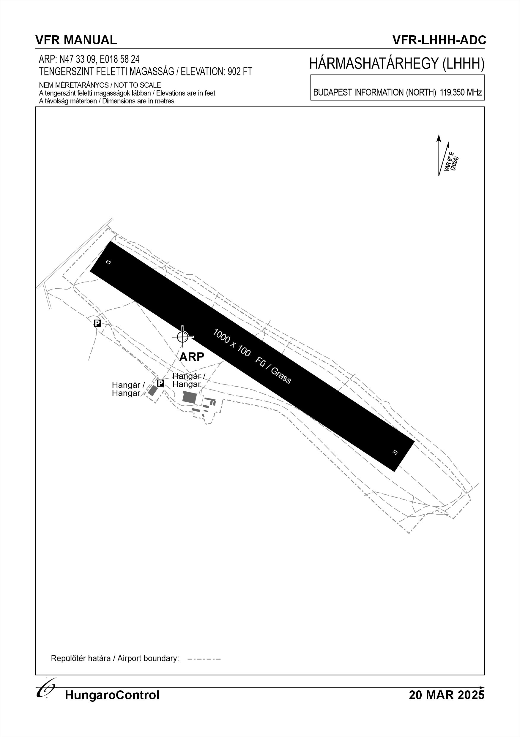
16. Runways (RWY)
|
RWY designator
|
True bearing
|
Magnetic bearing
|
Length (M)
|
Width (M)
|
Strength
|
Surface
|
Remarks
|
|---|---|---|---|---|---|---|---|
| 13 | 127° | 121° | 1000 | 100 | 10 t (5.7 t) | Grass | The airport can only be used below 5.7 t MTOW |
| 31 | 307° | 301° | 1000 | 100 | 10 t (5.7 t) | Grass | The airport can only be used below 5.7 t MTOW |
17. Aerodrome obstacles
|
RWY designator
|
Obstacle type
|
Elevation
|
Height
|
Coordinates
|
Remarks
|
|---|---|---|---|---|---|
| 13 | Transmission line | 316 M | 25 M | NIL | 305°/ 450 M |
| 13 | Mountain | 400 M | 125 M | NIL | 100° / 1400 M |
| 13 | Buildings | 283 M | 10 M | NIL | 305° / 240 M |
| 31 | Transmission line | 316 M | 25 M | NIL | 305° / 1450 M |
| 31 | Mountain | 400 M | 125 M | NIL | 25° / 400 M |
| 31 | Buildings | 283 M | 10 M | NIL | 305° / 1160 M |
18. Stopways (SWY)
|
RWY designator
|
Length (M)
|
Width (M)
|
Strength
|
Surface
|
Slope (%)
|
Remarks
|
|---|---|---|---|---|---|---|
| 13 | NIL | NIL | NIL | NIL | NIL | NIL |
| 31 | NIL | NIL | NIL | NIL | NIL | NIL |
19. Clearways (CWY)
|
RWY designator
|
Length (M)
|
Width (M)
|
Slope (%)
|
Remarks
|
|---|---|---|---|---|
| 13 | NIL | NIL | NIL | NIL |
| 31 | NIL | NIL | NIL | NIL |
20. STRIP
|
RWY designator
|
Length (M)
|
Width (M)
|
Remarks
|
|---|---|---|---|
| 13 | NIL | NIL | NIL |
| 31 | NIL | NIL | NIL |
21. RESA
|
RWY designator
|
Length (M)
|
Width (M)
|
Surface
|
Obstacle free zone (OFZ)
|
Remarks
|
|---|---|---|---|---|---|
| 13 | NIL | NIL | NIL | NIL | NIL |
| 31 | NIL | NIL | NIL | NIL | NIL |
22. Declared distances
|
RWY designator
|
TORA (M)
|
TODA (M)
|
ASDA (M)
|
LDA (M)
|
Remarks
|
|---|---|---|---|---|---|
| 13 | 1000 | 1000 | 1000 | 1000 | NIL |
| 31 | 1000 | 1000 | 1000 | 1000 | NIL |
23. Approach lighting
|
RWY designator
|
Type
|
Length (M)
|
Intensity
|
Remarks
|
|---|---|---|---|---|
| 13 | NIL | NIL | NIL | NIL |
| 31 | NIL | NIL | NIL | NIL |
24. Threshold lighting
|
RWY designator
|
Colour
|
Wing bar lights
|
Remarks
|
|---|---|---|---|
| 13 | NIL | NIL | NIL |
| 31 | NIL | NIL | NIL |
25. Visual approach slope indicator system lighting
|
RWY designator
|
Type
|
Data
|
Remarks
|
|---|---|---|---|
| 13 | NIL | NIL | NIL |
| 31 | NIL | NIL | NIL |
26. Touchdone zone lighting
|
RWY designator
|
Length of lighting (M)
|
Remarks
|
|---|---|---|
| 13 | NIL | NIL |
| 31 | NIL | NIL |
27. Runway centreline lighting
|
RWY designator
|
Length (M)
|
Spacing (M)
|
Colour
|
Intensity
|
Remarks
|
|---|---|---|---|---|---|
| 13 | NIL | NIL | NIL | NIL | NIL |
| 31 | NIL | NIL | NIL | NIL | NIL |
28. Runway edgeline lighting
|
RWY designator
|
Length (M)
|
Spacing (M)
|
Colour
|
Intensity
|
Remarks
|
|---|---|---|---|---|---|
| 13 | NIL | NIL | NIL | NIL | NIL |
| 31 | NIL | NIL | NIL | NIL | NIL |
29. Runway end lighting
|
RWY designator
|
Colour
|
Remarks
|
|---|---|---|
| 13 | NIL | NIL |
| 31 | NIL | NIL |
30. Runway wing bars lighting
|
RWY designator
|
Colour
|
Remarks
|
|---|---|---|
| 13 | NIL | NIL |
| 31 | NIL | NIL |
31. Stopway lighting
|
RWY designator
|
Length of lighting (M)
|
Colour
|
Remarks
|
|---|---|---|---|
| 13 | NIL | NIL | NIL |
| 31 | NIL | NIL | NIL |
32. Other lighting, secondary power supply
- ABN/IBN location, charasteristics and hours of operation
- NIL
- LDI location and lighting
- NIL
- Anemometer location and lighting
- Location: on top of the antenna next to the hangar (időkép.hu)Lighting: NIL
- 4Centre line lighting
- NIL
- TWY edge line lighting
- NIL
- Secondary power supply
- NIL
- Switch-over time
- NIL
- Remarks
- NIL
33. Helicopter landing area
- Coordinates TLOF or THR of FATO
- NIL
- TLOF and/or FATO elevation
- NIL
- TLOF and FATO area marking
- NIL
- TLOF and FATO area dimensions (M)
- NIL
- TLOF and FATO area surface
- NIL
- TLOF and FATO area strength
- NIL
- True BRG of FATO
- NIL
- MAG BRG of FATO
- NIL
- Declared distances available
- NIL
- APP and FATO lighting
- NIL
- Remarks
- NIL
34. Meteorological information provider
- Associated MET Office
- HungaroMet Magyar Meteorológiai Szolgáltató Nonprofit Zrt. (HungaroMet Zrt.), Unit of Aviation Meteorology
- Hours of service
- H24
- Office responsible for TAF preparation
- HungaroMet Magyar Meteorológiai Szolgáltató Nonprofit Zrt. (HungaroMet Zrt.), Unit of Aviation Meteorology
- Periods of validity
- NIL
- Interval of issuance
- NIL
- Type of landing forecast
- NIL
- Landing forecast interval of issuance
- NIL
- Briefing/consultation provided
- Written briefing: https://aviation.met.hu;Consultation via phone: +36-90/603-424;Consultation via e-mail: rvo@met.hu;
- Flight documentation
- Charts, abbreviated plain language text
- Language(s) used
- HU, EN
- Charts and other information available for briefing or consultation
- Charts, aerodrome reports and forecasts in EUR region, area forecasts, MET. observations and warnings in Budapest FIR
- Supplementary equipment available for providing information
- Self-briefing via aviation.met.hu
- ATS Units provided with information
- Budapest FIC (on request)
- Remarks
- NIL
35. Air traffic service airspace
- Designation
- NIL
- Lateral limits
- NIL
- Vertical limits (FT)
- NIL
- Airspace classification
- NIL
- ATS unit call sign
- NIL
- Languages used
- NIL
- Transition altitude (FT)
- NIL
- Remarks
- NIL
37. Local aerodrome regulations
Due to local conditions (obstacle conditions, slope, etc.), take-off and/or over take-off from the airport by fixed wing aircraft from runway 13 is FORBIDDEN (Exception - powered hang gliders and UL) School and performance gliders should fly over the 120 KV power line - maintaining adequate clearance, but at least 50 m above the ground when landing. The coordination of daily operations is organised on a daily basis by the responsible manager or his/her deputies, depending on the weather and the flight operation or operations. During motorised towing operations, aircraft should not approach the 120KV high-voltage power line closer than 50 m. Powered and unpowered aircraft and aircraft not fitted with an engine shall use the designated traffic circle, but may deviate from this during the daily coordination of the responsible daily flight operations by the Operations Manager or his/her representative. The traffic circle height is 1200 feet AMSL for powered fixed-wing aircraft. For unpowered aircraft and aircraft at a reasonable and safe altitude. A vadon élő állatokat és a kirándulókat az üzemeltetó igyekszik távol tartani, de azok megjelenése nem kizárható. For more information, see the Airport Rules.
Activities at the airport (Yes / No)
- Unmanned aerial vehicle (D)
- Yes
- Ballon (B)
- Yes
- Ultralight (U)
- Yes
- Hang glider (N)
- Yes
- Short take-off and landing (R)
- Yes
- Landplane (L)
- Yes
- Paraglider (P)
- Yes
- Glider (G)
- Yes
- Amphibian (A)
- Yes
- Helicopter (H)
- Yes
- Gyrocopter (G)
- Yes
- Tilt-wing aircraft (T)
- Yes
- Other (O)
- NIL
38. Noise abatement procedures
Flying by motorised aircraft over surrounding populated areas below 300m (QFE) for landing purposes only.
After take-off from runway 31, turn right over the airport area, following the 120KV power line parallel to the runway, and continue climbing to avoid the populated area. Taxiing in a powered aircraft is possible on basic throttle, but at a minimum power level sufficient to move the vehicle. Engine tests for powered aircraft are carried out in the hangar lobby. the valley side of the hangar with the nose of the aircraft towards the buildings facing the front. Rear gliders may be flown, their engines operated and engine tests are prohibited.
After take-off from runway 31, turn right over the airport area, following the 120KV power line parallel to the runway, and continue climbing to avoid the populated area. Taxiing in a powered aircraft is possible on basic throttle, but at a minimum power level sufficient to move the vehicle. Engine tests for powered aircraft are carried out in the hangar lobby. the valley side of the hangar with the nose of the aircraft towards the buildings facing the front. Rear gliders may be flown, their engines operated and engine tests are prohibited.
39. Aerodrome charges
NIL
40. Additional information
For more information, see the Airport Rules.
41. Aerodrome obstacles
- No obstacle text
- NIL
- RWY designator
- NIL
- Obstacle type
- NIL
- Elevation
- NIL
- Height
- NIL
- Coordinates
- NIL
- Remarks
- NIL