LHGD Gödöllő Airport
Last updated: 2025.11.27.
1. Aerodrome identification
- Aerodrome location indicator
- LHGD
- Aerodrome name
- Gödöllő Airport
- Aerodrome place name
- Gödöllő
2. Contact
- Address
- 2100 Gödöllő, Repülőtér, hrsz: 0114
- Phone
- +36-30/934-3199
- info@godolloairport.hu
3. Gallery
Teljes képernyő
Teljes
képernyő bezárása
Teljes képernyő
Teljes
képernyő bezárása
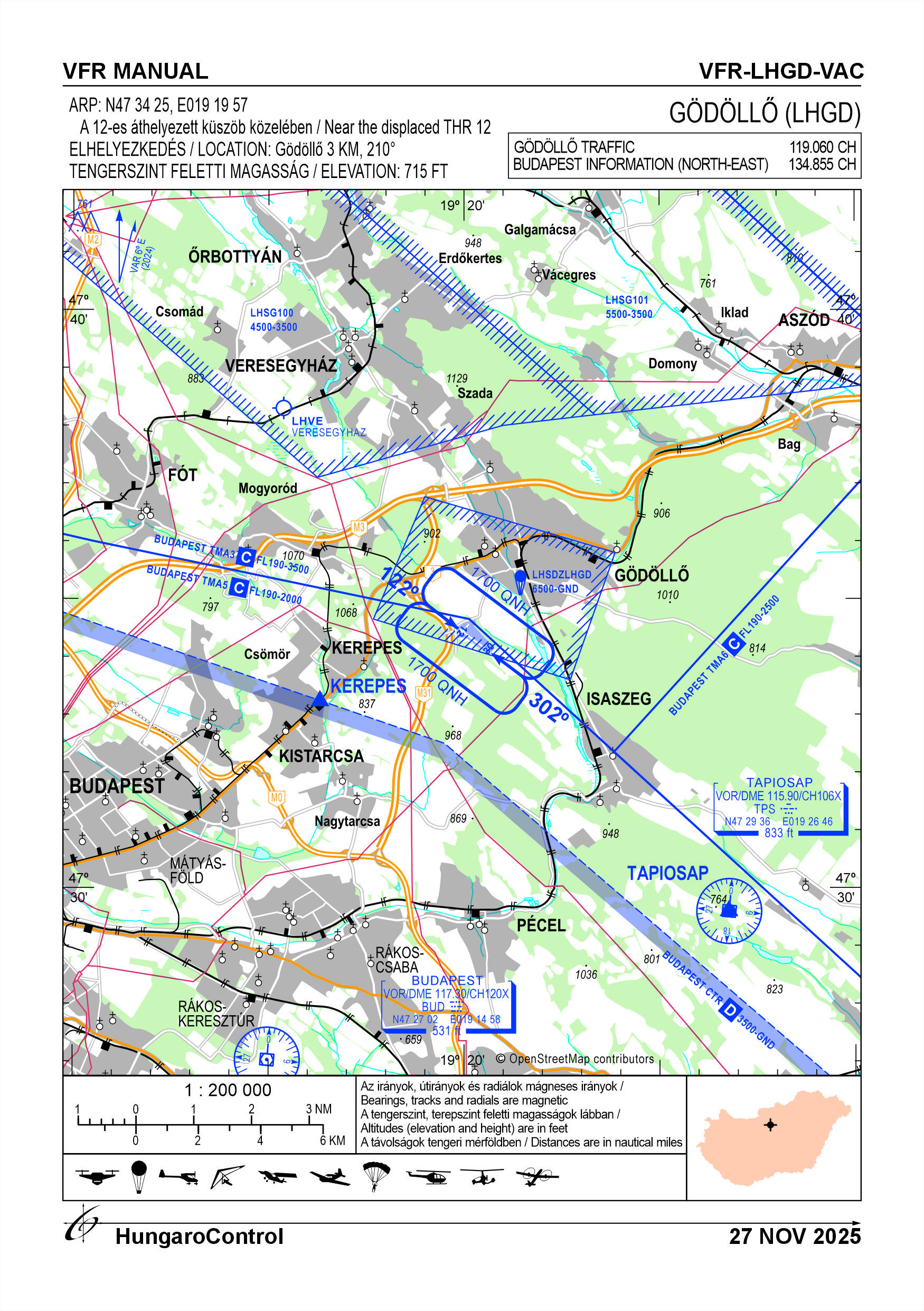
5. Aerodrome geographical and administrative data
ARP data
- Coordinates
- 473425N 0191957E
- Site at aerodrome
- Near the displaced THR 12
Location of aerodrome
- Distance from city (KM)
- Gödöllő 3 KM
- Direction from city
- 210°
- Elevation
- 715 FT
Magnetic variation data
- Degree of magnetic variation ( °)
- 5°48' E
- Annual change ( °)
- +0°09'
- Year of survey
- 2024
Aerodrome operator data
- Name
- Sky Escort Hungary Aero Club
- Address
- 2100 Gödöllő, Repülőtér
- Phone
- +36-30/934-3199
- Fax
- NIL
- Web
- NIL
- info@godolloairport.hu
Aerodrome data
- Name
- 2100 Gödöllő, Repülőtér, hrsz: 0114
- Phone
- +36-30/934-3199 (Both Lajos)
- Fax
- NIL
- Web
- NIL
- info@godolloairport.hu
- AFS
- NIL
- SITA
- NIL
- Others
- NIL
- Type of traffic allowed at the aerodrome
- VFR
- Remarks
- Special airport for civil use
- Responsible operator's name
- NIL
- Time logged
- NIL
6. Air traffic services communication facitlities
|
Service designation
|
Call sign
|
Channel
|
Languages used
|
Hours of operation
|
Remarks
|
|---|---|---|---|---|---|
| Gödöllő Traffic | Gödöllő Traffic | 119.060 CH | HU | In operating hours | NIL |
7. Operation hours
- AD Administration
- Between maximum sunrise -30 minutes and maximum sunset +45 minutes, but not longer than twilight, whichever is the stricter, and in conditions suitable for VFR flights on snow-free days.
- Customs and immigration
- NIL
- Health and sanitation
- NIL
- AIS Briefing Office
- NIL
- ATS Reporting Office (ARO)
- NIL
- MET Briefing Office
- NIL
- ATS
- NIL
- Fuelling
- For contracted partners only
- Handling
- NIL
- Security
- NIL
- De-icing
- NIL
- Remarks
- The airport operates only on snow-free days
8. Available handling services and facilities
- Cargo-handling facilities
- NIL
- Fuel types
- AVGAS 100LL, ESZ-95/E10
- Oil types
- NIL
- Fuelling facilities and capacity
- Fuel filling station
- De-icing facilities
- NIL
- Hangar space for visiting aircraft
- For contracted partners only
- Repair facilities for visiting aircraft
- NIL
- Remarks
- NIL
9. Passenger facilities
- Hotels
- In the city
- Restaurants
- In the city
- Transportation
- Taxi
- Medical facilities
- First aid at AD, hospital in the city of Kistarcsa
- Bank and Post Office
- In the city
- Tourist Office
- In the city
- Remarks
- NIL
10. Available rescue and fire fighting services
- Aerodrome catogory for fire fighting
- Categories 1, 2 and up to 3 as defined in Annex 3 to Government Decree 85/2024 (IV.17) depending on the activity currently being carried out. Only organisations authorised in writing may carry out economic activities.
- Available rescue and fire fighting services
- A total of 5 persons, but they are only on duty subject to the activities authorised by the operator, in the number of staff required for the activity.
- Rescue and fire fighting equipment
- Fire extinguishers and equipment in category 3 of Annex 3 of Government Decree 85/2024 (IV.17).
- Capability for removal of disabled aircraft
- NIL
- Remarks
- The airport operates only on snow-free days
11. Clearing
- Types of clearing equipment
- NIL
- Clearance priorities
- NIL
- Remarks
- The airport operates only on snow-free days.
12. Aprons
|
Designation
|
Surface
|
Strength
|
Remarks
|
Designator
|
|---|---|---|---|---|
| NIL | NIL | NIL | NIL | NIL |
13. Taxiways
|
Designation
|
Surface
|
Strength
|
Width (M)
|
Remarks
|
Designatior
|
|---|---|---|---|---|---|
| NIL | NIL | NIL | NIL | NIL | NIL |
14. Checkpoints
Altimeter checkpoints and locations data
- Coordinates
- NIL
- Technical data
- NIL
- VOR checkpoints
- NIL
- INS checkpoints
- NIL
- Remarks
- NIL
15. Surface movement guidance and control system and markings
- Use of aircraft stand ID signs, TWY guide lines and visual docking/parking guidance system of aircraft stands
- NIL
- RWY and TWY markings and lighting
- RWY threshold signs, edge signs
- Stop bars
- NIL
- Remarks
- NIL
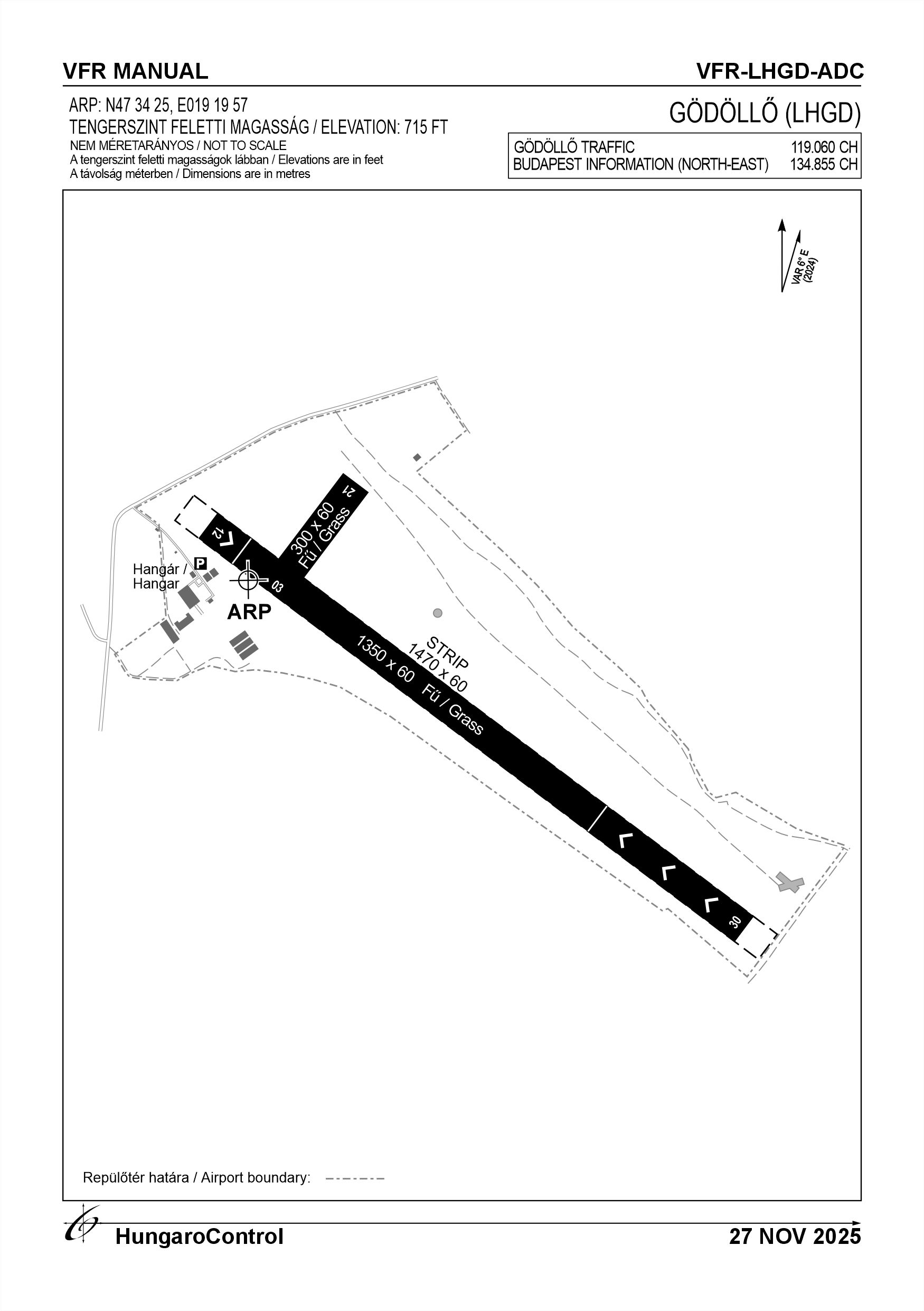
16. Runways (RWY)
|
RWY designator
|
True bearing
|
Magnetic bearing
|
Length (M)
|
Width (M)
|
Strength
|
Surface
|
Remarks
|
|---|---|---|---|---|---|---|---|
| 12 | 128° | 122° | 1350 | 60 | 20 t (10 t) | Grass | Displaced threshold in 120° direction 120 M |
| 30 | 308° | 302° | 1350 | 60 | 20 t (10 t) | Grass | Displaced threshold in 300° direction 370 M |
| 03 | 039° | 033° | 300 | 60 | 20 t (10 t) | Grass | For take-off only |
| 21 | 219° | 213° | 300 | 60 | 20 t (10 t) | Grass | For landing only |
17. Aerodrome obstacles
|
RWY designator
|
Obstacle type
|
Elevation
|
Height
|
Coordinates
|
Remarks
|
|---|---|---|---|---|---|
| 03 | Woods | 715 FT | 8 M | NIL | NIL |
| 12 | Group of trees | 715 FT | 5 M | NIL | NIL |
18. Stopways (SWY)
|
RWY designator
|
Length (M)
|
Width (M)
|
Strength
|
Surface
|
Slope (%)
|
Remarks
|
|---|---|---|---|---|---|---|
| 12 | NIL | NIL | NIL | NIL | NIL | NIL |
| 30 | NIL | NIL | NIL | NIL | NIL | NIL |
| 03 | NIL | NIL | NIL | NIL | NIL | NIL |
| 21 | NIL | NIL | NIL | NIL | NIL | NIL |
19. Clearways (CWY)
|
RWY designator
|
Length (M)
|
Width (M)
|
Slope (%)
|
Remarks
|
|---|---|---|---|---|
| 12 | NIL | NIL | NIL | NIL |
| 30 | NIL | NIL | NIL | NIL |
| 03 | NIL | NIL | NIL | NIL |
| 21 | NIL | NIL | NIL | NIL |
20. STRIP
|
RWY designator
|
Length (M)
|
Width (M)
|
Remarks
|
|---|---|---|---|
| 12 | 1470 | 60 | NIL |
| 30 | 1470 | 60 | NIL |
| 03 | NIL | NIL | NIL |
| 21 | NIL | NIL | NIL |
21. RESA
|
RWY designator
|
Length (M)
|
Width (M)
|
Surface
|
Obstacle free zone (OFZ)
|
Remarks
|
|---|---|---|---|---|---|
| 12 | NIL | NIL | NIL | NIL | NIL |
| 30 | NIL | NIL | NIL | NIL | NIL |
| 03 | NIL | NIL | NIL | NIL | NIL |
| 21 | NIL | NIL | NIL | NIL | NIL |
22. Declared distances
|
RWY designator
|
TORA (M)
|
TODA (M)
|
ASDA (M)
|
LDA (M)
|
Remarks
|
|---|---|---|---|---|---|
| 12 | 1350 | 1350 | 1350 | 1350 | Between the displaced thresholds 860 M |
| 30 | 1350 | 1350 | 1350 | 1350 | Between the displaced thresholds 860 M |
| 03 | 300 | 300 | 300 | NIL | For take-off only |
| 21 | NIL | NIL | NIL | 300 | For landing only |
23. Approach lighting
|
RWY designator
|
Type
|
Length (M)
|
Intensity
|
Remarks
|
|---|---|---|---|---|
| 12 | NIL | NIL | NIL | NIL |
| 30 | NIL | NIL | NIL | NIL |
| 03 | NIL | NIL | NIL | NIL |
| 21 | NIL | NIL | NIL | NIL |
24. Threshold lighting
|
RWY designator
|
Colour
|
Wing bar lights
|
Remarks
|
|---|---|---|---|
| 12 | NIL | NIL | NIL |
| 30 | NIL | NIL | NIL |
| 03 | NIL | NIL | NIL |
| 21 | NIL | NIL | NIL |
25. Visual approach slope indicator system lighting
|
RWY designator
|
Type
|
Data
|
Remarks
|
|---|---|---|---|
| 12 | NIL | NIL | NIL |
| 30 | NIL | NIL | NIL |
| 03 | NIL | NIL | NIL |
| 21 | NIL | NIL | NIL |
26. Touchdone zone lighting
|
RWY designator
|
Length of lighting (M)
|
Remarks
|
|---|---|---|
| 12 | NIL | NIL |
| 30 | NIL | NIL |
| 03 | NIL | NIL |
| 21 | NIL | NIL |
27. Runway centreline lighting
|
RWY designator
|
Length (M)
|
Spacing (M)
|
Colour
|
Intensity
|
Remarks
|
|---|---|---|---|---|---|
| 12 | NIL | NIL | NIL | NIL | NIL |
| 30 | NIL | NIL | NIL | NIL | NIL |
| 03 | NIL | NIL | NIL | NIL | NIL |
| 21 | NIL | NIL | NIL | NIL | NIL |
28. Runway edgeline lighting
|
RWY designator
|
Length (M)
|
Spacing (M)
|
Colour
|
Intensity
|
Remarks
|
|---|---|---|---|---|---|
| 12 | NIL | NIL | NIL | NIL | NIL |
| 30 | NIL | NIL | NIL | NIL | NIL |
| 03 | NIL | NIL | NIL | NIL | NIL |
| 21 | NIL | NIL | NIL | NIL | NIL |
29. Runway end lighting
|
RWY designator
|
Colour
|
Remarks
|
|---|---|---|
| 12 | NIL | NIL |
| 30 | NIL | NIL |
| 03 | NIL | NIL |
| 21 | NIL | NIL |
30. Runway wing bars lighting
|
RWY designator
|
Colour
|
Remarks
|
|---|---|---|
| 12 | NIL | NIL |
| 30 | NIL | NIL |
| 03 | NIL | NIL |
| 21 | NIL | NIL |
31. Stopway lighting
|
RWY designator
|
Length of lighting (M)
|
Colour
|
Remarks
|
|---|---|---|---|
| 12 | NIL | NIL | NIL |
| 30 | NIL | NIL | NIL |
| 03 | NIL | NIL | NIL |
| 21 | NIL | NIL | NIL |
32. Other lighting, secondary power supply
- ABN/IBN location, charasteristics and hours of operation
- NIL
- LDI location and lighting
- NIL
- Anemometer location and lighting
- NIL
- 4Centre line lighting
- NIL
- TWY edge line lighting
- NIL
- Secondary power supply
- NIL
- Switch-over time
- NIL
- Remarks
- NIL
33. Helicopter landing area
- Coordinates TLOF or THR of FATO
- NIL
- TLOF and/or FATO elevation
- NIL
- TLOF and FATO area marking
- NIL
- TLOF and FATO area dimensions (M)
- NIL
- TLOF and FATO area surface
- NIL
- TLOF and FATO area strength
- NIL
- True BRG of FATO
- NIL
- MAG BRG of FATO
- NIL
- Declared distances available
- NIL
- APP and FATO lighting
- NIL
- Remarks
- NIL
34. Meteorological information provider
- Associated MET Office
- HungaroMet Magyar Meteorológiai Szolgáltató Nonprofit Zrt. (HungaroMet Zrt.), Unit of Aviation Meteorology
- Hours of service
- H24
- Office responsible for TAF preparation
- HungaroMet Magyar Meteorológiai Szolgáltató Nonprofit Zrt. (HungaroMet Zrt.), Unit of Aviation Meteorology
- Periods of validity
- NIL
- Interval of issuance
- NIL
- Type of landing forecast
- NIL
- Landing forecast interval of issuance
- NIL
- Briefing/consultation provided
- Written briefing: https://aviation.met.hu;Consultation via phone: +36-90/603-424;Consultation via e-mail: rvo@met.hu;
- Flight documentation
- Charts, abbreviated plain language text
- Language(s) used
- HU, EN
- Charts and other information available for briefing or consultation
- Charts, aerodrome reports and forecasts in EUR region, area forecasts, MET. observations and warnings in Budapest FIR
- Supplementary equipment available for providing information
- Self-briefing via aviation.met.hu
- ATS Units provided with information
- Budapest FIC (on request)
- Remarks
- NIL
35. Air traffic service airspace
- Designation
- LHSDZLHGD / GÖDÖLLŐ
- Lateral limits
- 473646N 0191900E - 473439N 0191741E - 473336N 0192243E - 473548N 0192352E - 473646N 0191900E
- Vertical limits (FT)
- GND - 6500 FT ALT
- Airspace classification
- NIL
- ATS unit call sign
- NIL
- Languages used
- HU
- Transition altitude (FT)
- NIL
- Remarks
- NIL
37. Local aerodrome regulations
Lessees, private companies and training organisations that have a contract with the airport managing body must notify the airport managing body before the start of their daily flight operations. The coordination of daily operations shall be organised on a daily basis by the airport manager in charge or his delegate. Only aircraft whose commander has been authorised by the operator to use the aerodrome may use the aerodrome. The operator shall endeavour to keep wild animals out, but their presence cannot be excluded. The aerodrome is suitable for VFR flights only. RWY 30 - runway with ground visual signals: suitable for take-off and landing, right/left traffic circle possible during take-off. RWY 12 - runway with visual ground signs: suitable for landing and take-off, with the possibility of performing a right/left traffic circle during take-off. RWY 21 - only for landing, no traffic circle is assigned. RWY 03 - suitable for take-off only, no traffic circle marked. For more information, see the current Airport Rules.
Activities at the airport (Yes / No)
- Unmanned aerial vehicle (D)
- Yes, by prior permission
- Ballon (B)
- Yes, by prior permission
- Ultralight (U)
- Yes, by prior permission
- Hang glider (N)
- Yes, by prior permission
- Short take-off and landing (R)
- Yes
- Landplane (L)
- Yes
- Paraglider (P)
- Yes
- Glider (G)
- No
- Amphibian (A)
- No
- Helicopter (H)
- Yes
- Gyrocopter (G)
- Yes
- Tilt-wing aircraft (T)
- Yes
- Other (O)
- NIL
38. Noise abatement procedures
In order to ensure the undisturbed rest of the city of Gödöllő on Sundays and rest days and to reduce noise pollution, the airport operator may regulate the structure of traffic circles for training and school take-offs and exercises. In exceptional cases only, powered aircraft with a sound pressure level exceeding 85 dBA (measured at take-off power) may be flown over the inhabited areas of the city of Gödöllő for the purpose of gaining height. The airport may only be used by aircraft with a noise certificate in accordance with Joint Decree 18/1997 KVHM-KTM $ 11 (1). Flight procedures shall be based on the published noise protection zone calculations.
39. Aerodrome charges
None
40. Additional information
For more information, see the Airport Rules.
41. Aerodrome obstacles
- No obstacle text
- NIL
- RWY designator
- NIL
- Obstacle type
- NIL
- Elevation
- NIL
- Height
- NIL
- Coordinates
- NIL
- Remarks
- NIL