LHFM Fertőszentmiklós Airport
Last updated: 2025.03.20.
1. Aerodrome identification
- Aerodrome location indicator
- LHFM
- Aerodrome name
- Fertőszentmiklós Airport
- Aerodrome place name
- Fertőszentmiklós
2. Contact
- Address
- 9444 Fertőszentmiklós, Repülőtéri út 1.
- Phone
- +36-99/544-020, +36-20/942-7777
- tothrobi777@gmail.com
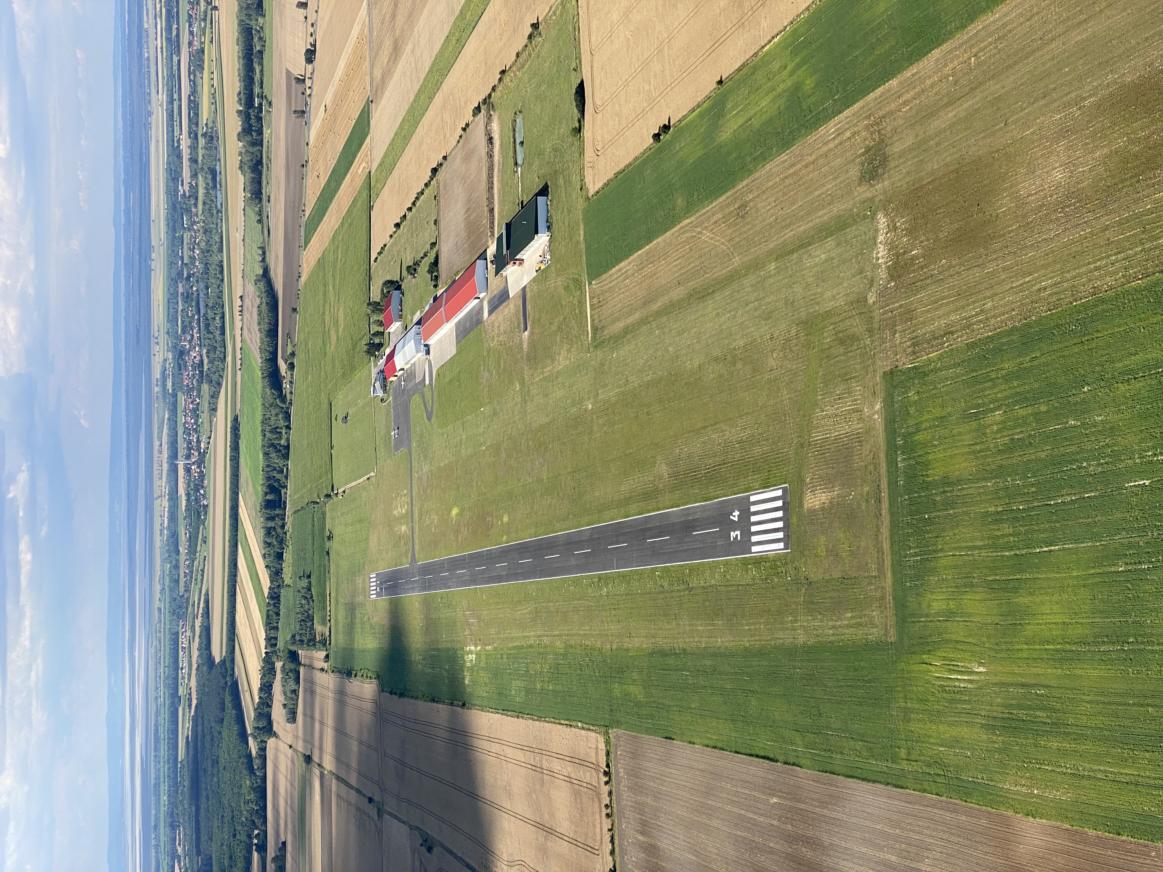
3. Gallery
Teljes képernyő
Teljes
képernyő bezárása

Teljes képernyő
Teljes
képernyő bezárása

Teljes képernyő
Teljes
képernyő bezárása

Teljes képernyő
Teljes
képernyő bezárása
5. Aerodrome geographical and administrative data
ARP data
- Coordinates
- 473501N 0165042E
- Site at aerodrome
- 595 M from the THR 13
Location of aerodrome
- Distance from city (KM)
- Fertőszentmiklós 1 KM
- Direction from city
- 270°
- Elevation
- 440 FT
Magnetic variation data
- Degree of magnetic variation ( °)
- 5°18' E
- Annual change ( °)
- +0°09'
- Year of survey
- 2024
Aerodrome operator data
- Name
- Meidl Airport Kft.
- Address
- 9444 Fertőszentmiklós, Repülőtéri út 1.
- Phone
- +36-99/544-020, +36-20/942-7777
- Fax
- +36-99/381-690
- office@meidlairport.com
Aerodrome data
- Name
- 9444 Fertőszentmiklós, Repülőtéri út 1.
- Phone
- +36-99/544-020 (Tóth Róbert)
- Fax
- +36-99/381-690
- tothrobi777@gmail.com
- AFS
- NIL
- SITA
- NIL
- Others
- NIL
- Type of traffic allowed at the aerodrome
- VFR
- Remarks
- Special airport for civil use
- Responsible operator's name
- NIL
- Time logged
- NIL
6. Air traffic services communication facitlities
|
Service designation
|
Call sign
|
Channel
|
Languages used
|
Hours of operation
|
Remarks
|
|---|---|---|---|---|---|
| Fertő Rádió | Fertő Rádió | 118.935 CH | HU | During airport operating hours | NIL |
7. Operation hours
- AD Administration
- With the prior authorisation of the operator
- Customs and immigration
- NIL
- Health and sanitation
- NIL
- AIS Briefing Office
- NIL
- ATS Reporting Office (ARO)
- NIL
- MET Briefing Office
- NIL
- ATS
- NIL
- Fuelling
- NIL
- Handling
- NIL
- Security
- NIL
- De-icing
- NIL
- Remarks
- NIL
8. Available handling services and facilities
- Cargo-handling facilities
- NIL
- Fuel types
- 100 LL AVGAS, JET-A1, EURO-100
- Oil types
- Shell 100/50
- Fuelling facilities and capacity
- Fuel station
- De-icing facilities
- NIL
- Hangar space for visiting aircraft
- Wingspan: 20 metres, Height: 6.8 metres
- Repair facilities for visiting aircraft
- 50/100 hour care by prior arrangement with the airport manager
- Remarks
- NIL
9. Passenger facilities
- Hotels
- In the city
- Restaurants
- On the airport
- Transportation
- Taxi and Rent car
- Medical facilities
- In the city
- Bank and Post Office
- In the city
- Tourist Office
- NIL
- Remarks
- NIL
10. Available rescue and fire fighting services
- Aerodrome catogory for fire fighting
- Category 3 as defined in Annex 3 to Government Decree 85/2024 (IV.17)
- Available rescue and fire fighting services
- 10 x 12 kg kg powder extinguisher (10*15=150 OE) - 1 motor vehicle, - tension cutter, - pickaxe, - ladder, - gloves, - crowbar, - hacksaw, - axe, - hammer, - shovel, - pliers, - combination pliers, - pipe wrench, - sanitary box
- Rescue and fire fighting equipment
- NIL
- Capability for removal of disabled aircraft
- NIL
- Remarks
- NIL
11. Clearing
- Types of clearing equipment
- NIL
- Clearance priorities
- NIL
- Remarks
- The airport operates only on snow-free days.
12. Aprons
|
Designation
|
Surface
|
Strength
|
Remarks
|
Designator
|
|---|---|---|---|---|
| Apron 1 | Asphalt | PCN 15/F/B/X/T | NIL | NIL |
13. Taxiways
|
Designation
|
Surface
|
Strength
|
Width (M)
|
Remarks
|
Designatior
|
|---|---|---|---|---|---|
| A | Asphalt | PCN 15/F/B/X/T | 10.5 | NIL | NIL |
14. Checkpoints
Altimeter checkpoints and locations data
- Coordinates
- NIL
- Technical data
- NIL
- VOR checkpoints
- NIL
- INS checkpoints
- NIL
- Remarks
- NIL
15. Surface movement guidance and control system and markings
- Use of aircraft stand ID signs, TWY guide lines and visual docking/parking guidance system of aircraft stands
- NIL
- RWY and TWY markings and lighting
- RWY: Asphalt RWY in both directions: threshold, track edge and centre line markingsGrassed RWY in both directions: edge markingsTWY: "A" taxiway: centre line markings
- Stop bars
- NIL
- Remarks
- NIL
16. Runways (RWY)
|
RWY designator
|
True bearing
|
Magnetic bearing
|
Length (M)
|
Width (M)
|
Strength
|
Surface
|
Remarks
|
|---|---|---|---|---|---|---|---|
| 16 | 159° | 154° | 985 | 23 | PCN 15 | Asphalt | NIL |
| 34 | 339° | 334° | 985 | 23 | PCN 15 | Asphalt | NIL |
| 16 | 159° | 154° | 800 | 25 | 10 t (3 t) | Grass | NIL |
| 34 | 339° | 334° | 800 | 25 | 10 t (3 t) | Grass | NIL |
17. Aerodrome obstacles
|
RWY designator
|
Obstacle type
|
Elevation
|
Height
|
Coordinates
|
Remarks
|
|---|---|---|---|---|---|
| 16 | Antenna | 207 M | 73 M | 473517.8N 0165235.8E | 347° 800 M from THR16 |
| 34 | Transmission line | 157.6 M | 34.6 M | NIL | 540 m from the threshold, in a direction 340° along the track axis, in the approach area |
18. Stopways (SWY)
|
RWY designator
|
Length (M)
|
Width (M)
|
Strength
|
Surface
|
Slope (%)
|
Remarks
|
|---|---|---|---|---|---|---|
| 16 | NIL | NIL | NIL | NIL | NIL | NIL |
| 34 | NIL | NIL | NIL | NIL | NIL | NIL |
19. Clearways (CWY)
|
RWY designator
|
Length (M)
|
Width (M)
|
Slope (%)
|
Remarks
|
|---|---|---|---|---|
| 16 | NIL | NIL | NIL | NIL |
| 34 | NIL | NIL | NIL | NIL |
20. STRIP
|
RWY designator
|
Length (M)
|
Width (M)
|
Remarks
|
|---|---|---|---|
| 16 | 1105 | 80 | NIL |
| 34 | 1105 | 80 | NIL |
21. RESA
|
RWY designator
|
Length (M)
|
Width (M)
|
Surface
|
Obstacle free zone (OFZ)
|
Remarks
|
|---|---|---|---|---|---|
| 16 | NIL | NIL | NIL | NIL | NIL |
| 34 | NIL | NIL | NIL | NIL | NIL |
22. Declared distances
|
RWY designator
|
TORA (M)
|
TODA (M)
|
ASDA (M)
|
LDA (M)
|
Remarks
|
|---|---|---|---|---|---|
| 16 | 985 | 985 | 985 | 985 | Asphalt |
| 34 | 985 | 985 | 985 | 985 | Asphalt |
| 16 | 800 | 800 | 800 | 800 | Grass |
| 34 | 800 | 800 | 800 | 800 | Grass |
23. Approach lighting
|
RWY designator
|
Type
|
Length (M)
|
Intensity
|
Remarks
|
|---|---|---|---|---|
| 16 | NIL | NIL | NIL | NIL |
| 34 | NIL | NIL | NIL | NIL |
24. Threshold lighting
|
RWY designator
|
Colour
|
Wing bar lights
|
Remarks
|
|---|---|---|---|
| 16 | NIL | NIL | NIL |
| 34 | NIL | NIL | NIL |
25. Visual approach slope indicator system lighting
|
RWY designator
|
Type
|
Data
|
Remarks
|
|---|---|---|---|
| 16 | NIL | NIL | NIL |
| 34 | NIL | NIL | NIL |
26. Touchdone zone lighting
|
RWY designator
|
Length of lighting (M)
|
Remarks
|
|---|---|---|
| 16 | NIL | NIL |
| 34 | NIL | NIL |
27. Runway centreline lighting
|
RWY designator
|
Length (M)
|
Spacing (M)
|
Colour
|
Intensity
|
Remarks
|
|---|---|---|---|---|---|
| 16 | NIL | NIL | NIL | NIL | NIL |
| 34 | NIL | NIL | NIL | NIL | NIL |
28. Runway edgeline lighting
|
RWY designator
|
Length (M)
|
Spacing (M)
|
Colour
|
Intensity
|
Remarks
|
|---|---|---|---|---|---|
| 16 | NIL | NIL | NIL | NIL | NIL |
| 34 | NIL | NIL | NIL | NIL | NIL |
29. Runway end lighting
|
RWY designator
|
Colour
|
Remarks
|
|---|---|---|
| 16 | NIL | NIL |
| 34 | NIL | NIL |
30. Runway wing bars lighting
|
RWY designator
|
Colour
|
Remarks
|
|---|---|---|
| 16 | NIL | NIL |
| 34 | NIL | NIL |
31. Stopway lighting
|
RWY designator
|
Length of lighting (M)
|
Colour
|
Remarks
|
|---|---|---|---|
| 16 | NIL | NIL | NIL |
| 34 | NIL | NIL | NIL |
32. Other lighting, secondary power supply
- ABN/IBN location, charasteristics and hours of operation
- NIL
- LDI location and lighting
- NIL
- Anemometer location and lighting
- NIL
- 4Centre line lighting
- NIL
- TWY edge line lighting
- NIL
- Secondary power supply
- NIL
- Switch-over time
- NIL
- Remarks
- NIL
33. Helicopter landing area
- Coordinates TLOF or THR of FATO
- NIL
- TLOF and/or FATO elevation
- NIL
- TLOF and FATO area marking
- NIL
- TLOF and FATO area dimensions (M)
- NIL
- TLOF and FATO area surface
- NIL
- TLOF and FATO area strength
- NIL
- True BRG of FATO
- NIL
- MAG BRG of FATO
- NIL
- Declared distances available
- NIL
- APP and FATO lighting
- NIL
- Remarks
- NIL
34. Meteorological information provider
- Associated MET Office
- HungaroMet Magyar Meteorológiai Szolgáltató Nonprofit Zrt. (HungaroMet Zrt.), Unit of Aviation Meteorology
- Hours of service
- H24
- Office responsible for TAF preparation
- HungaroMet Magyar Meteorológiai Szolgáltató Nonprofit Zrt. (HungaroMet Zrt.), Unit of Aviation Meteorology
- Periods of validity
- NIL
- Interval of issuance
- NIL
- Type of landing forecast
- NIL
- Landing forecast interval of issuance
- NIL
- Briefing/consultation provided
- Written briefing: https://aviation.met.hu;Consultation via phone: +36-90/603-424;Consultation via e-mail: rvo@met.hu;
- Flight documentation
- Charts, abbreviated plain language text
- Language(s) used
- HU, EN
- Charts and other information available for briefing or consultation
- Charts, aerodrome reports and forecasts in EUR region, area forecasts, MET. observations and warnings in Budapest FIR
- Supplementary equipment available for providing information
- Self-briefing via aviation.met.hu
- ATS Units provided with information
- Budapest FIC (on request)
- Remarks
- NIL
35. Air traffic service airspace
- Designation
- LHSDZLHFM / FERTŐSZENTMIKLÓS
- Lateral limits
- 473557N 0165122E - 473416N 0165217E - 473322N 0165009E - 473339N 0164820E - 473441N 0164625E - 473556N 0164532E - 473557N 0165122E
- Vertical limits (FT)
- GND - FL125
- Airspace classification
- NIL
- ATS unit call sign
- NIL
- Languages used
- HU
- Transition altitude (FT)
- NIL
- Remarks
- NIL
37. Local aerodrome regulations
Shortening the traffic circle and flying over settlements is strictly forbidden, and failure to comply with the restrictions will result in the withdrawal of the use of the airport. The "small" traffic circles of 100m, 300 AGL marked on the map may only be executed by suitable Gyrocopters. The traffic circles can be viewed in the annex "maps". Aircraft may make movements at the airport under their own responsibility, making sure that they are safe. The aircraft must have radio equipment in working order for any communication with other aircraft. Aircraft may take off and land on the paved runway and the parallel grass runway. The simultaneous use of the grass runway and the asphalt runway for take-off and landing is prohibited. For more information, see the current Airport Rules.
Activities at the airport (Yes / No)
- Unmanned aerial vehicle (D)
- Yes
- Ballon (B)
- Yes
- Ultralight (U)
- Yes
- Hang glider (N)
- Yes
- Short take-off and landing (R)
- Yes
- Landplane (L)
- Yes
- Paraglider (P)
- Yes
- Glider (G)
- Yes
- Amphibian (A)
- No
- Helicopter (H)
- Yes
- Gyrocopter (G)
- Yes
- Tilt-wing aircraft (T)
- NIL
- Other (O)
- NIL
38. Noise abatement procedures
Aircraft must avoid residential areas during the flight of the traffic circle (school circle) and during approach and departure. Aircraft, after manual release from the hangar, shall be pushed to the opposite side of the apron with the nose towards the hangars and engine start-up and running shall be performed with the propeller blade or turbine blade in the neutral direction. The same applies to aircraft to be flown before servicing.
39. Aerodrome charges
See the Airport Rules or on the website
40. Additional information
For more information, see the Airport Rules.
41. Aerodrome obstacles
- No obstacle text
- NIL
- RWY designator
- NIL
- Obstacle type
- NIL
- Elevation
- NIL
- Height
- NIL
- Coordinates
- NIL
- Remarks
- NIL