LHER Eger Airport
Last updated: 2026.06.11.
1. Aerodrome identification
- Aerodrome location indicator
- LHER
- Aerodrome name
- Eger Airport
- Aerodrome place name
- Eger
2. Contact
- Address
- 3300 Eger, Vécsey völgy u. 0533/58, 0533/59 és 0533/100 hrsz. (külterület)
- Phone
- +36-20/316-8108 (Molnár Éva)
- apollorepuloter@gmail.com
3. Gallery
Teljes képernyő
Teljes
képernyő bezárása
Teljes képernyő
Teljes
képernyő bezárása
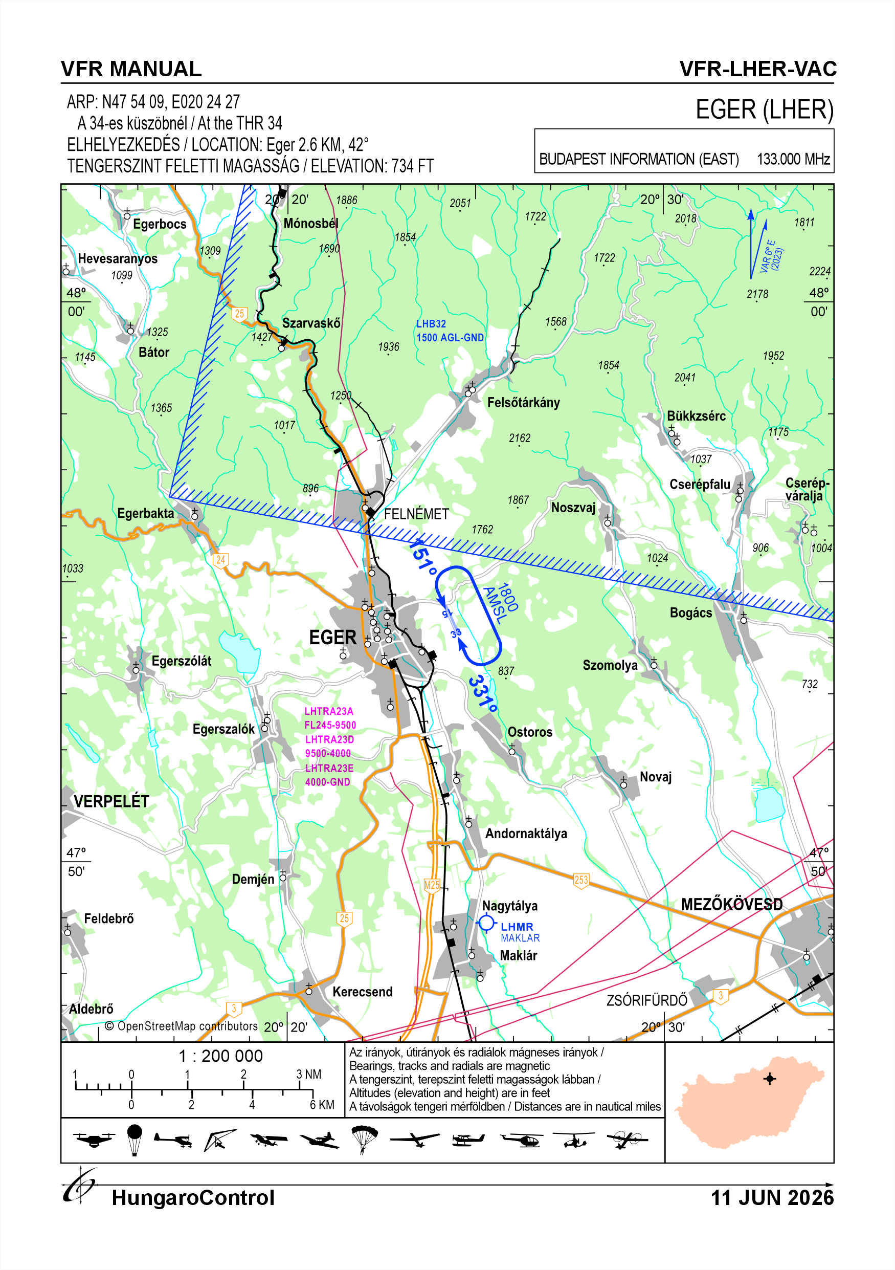
5. Aerodrome geographical and administrative data
ARP data
- Coordinates
- 475409N 0202427E
- Site at aerodrome
- At the THR 33
Location of aerodrome
- Distance from city (KM)
- Eger 2.6 KM
- Direction from city
- 42°
- Elevation
- 734 FT
Magnetic variation data
- Degree of magnetic variation ( °)
- 6° E
- Annual change ( °)
- +0.1°
- Year of survey
- 2023
Aerodrome operator data
- Name
- Molnár Éva
- Address
- 3300 Eger, Fertőbánya 26854 hrsz.
- Phone
- +36-20/316-8108 (Molnár Éva)
- Fax
- NIL
- Web
- NIL
- apollorepuloter@gmail.com
Aerodrome data
- Name
- 3300 Eger, Vécsey völgy u. 0533/58, 0533/59 és 0533/100 hrsz. (külterület)
- Phone
- +36-20/246-4402 (HU; Turi Ferenc), +36-30/300-4200 (EN; FR; RO)
- Fax
- NIL
- Web
- NIL
- apollorepuloter@gmail.com
- AFS
- NIL
- SITA
- NIL
- Others
- NIL
- Type of traffic allowed at the aerodrome
- VFR
- Remarks
- Special airport for civil use
- Responsible operator's name
- NIL
- Time logged
- NIL
6. Air traffic services communication facitlities
|
Service designation
|
Call sign
|
Channel
|
Languages used
|
Hours of operation
|
Remarks
|
|---|---|---|---|---|---|
| NIL | NIL | NIL | NIL | NIL | NIL |
7. Operation hours
- AD Administration
- In VFR conditions, on snow-free days
- Customs and immigration
- NIL
- Health and sanitation
- First aid at the airport during operating hours, hospital in Eger around the clock.
- AIS Briefing Office
- NIL
- ATS Reporting Office (ARO)
- NIL
- MET Briefing Office
- NIL
- ATS
- NIL
- Fuelling
- NIL
- Handling
- NIL
- Security
- NIL
- De-icing
- NIL
- Remarks
- NIL
8. Available handling services and facilities
- Cargo-handling facilities
- NIL
- Fuel types
- NIL
- Oil types
- NIL
- Fuelling facilities and capacity
- NIL
- De-icing facilities
- NIL
- Hangar space for visiting aircraft
- Limited, by prior arrangement
- Repair facilities for visiting aircraft
- NIL
- Remarks
- NIL
9. Passenger facilities
- Hotels
- In the city of Eger
- Restaurants
- In the city of Eger
- Transportation
- Taxi, Bus
- Medical facilities
- Hospital in the city of Eger
- Bank and Post Office
- In the city of Eger
- Tourist Office
- In the city of Eger
- Remarks
- NIL
10. Available rescue and fire fighting services
- Aerodrome catogory for fire fighting
- Category 1 as defined in Annex 3 to Government Decree 85/2024 (IV.17).
- Available rescue and fire fighting services
- NIL
- Rescue and fire fighting equipment
-
The equipment provided for in point 2.9 of Annex 3 of Government Decree 85/2024 (IV. 17);
Available extinguishing capacity: 48 OE with 43A 233B C MaxFire Green 6 kg, ABC powder extinguisher (4 pieces).
- Capability for removal of disabled aircraft
-
Crane trailers in the city
Motorised aircraft carrier
- Remarks
- NIL
11. Clearing
- Types of clearing equipment
- NIL
- Clearance priorities
- NIL
- Remarks
- The airport operates only on snow-free days.
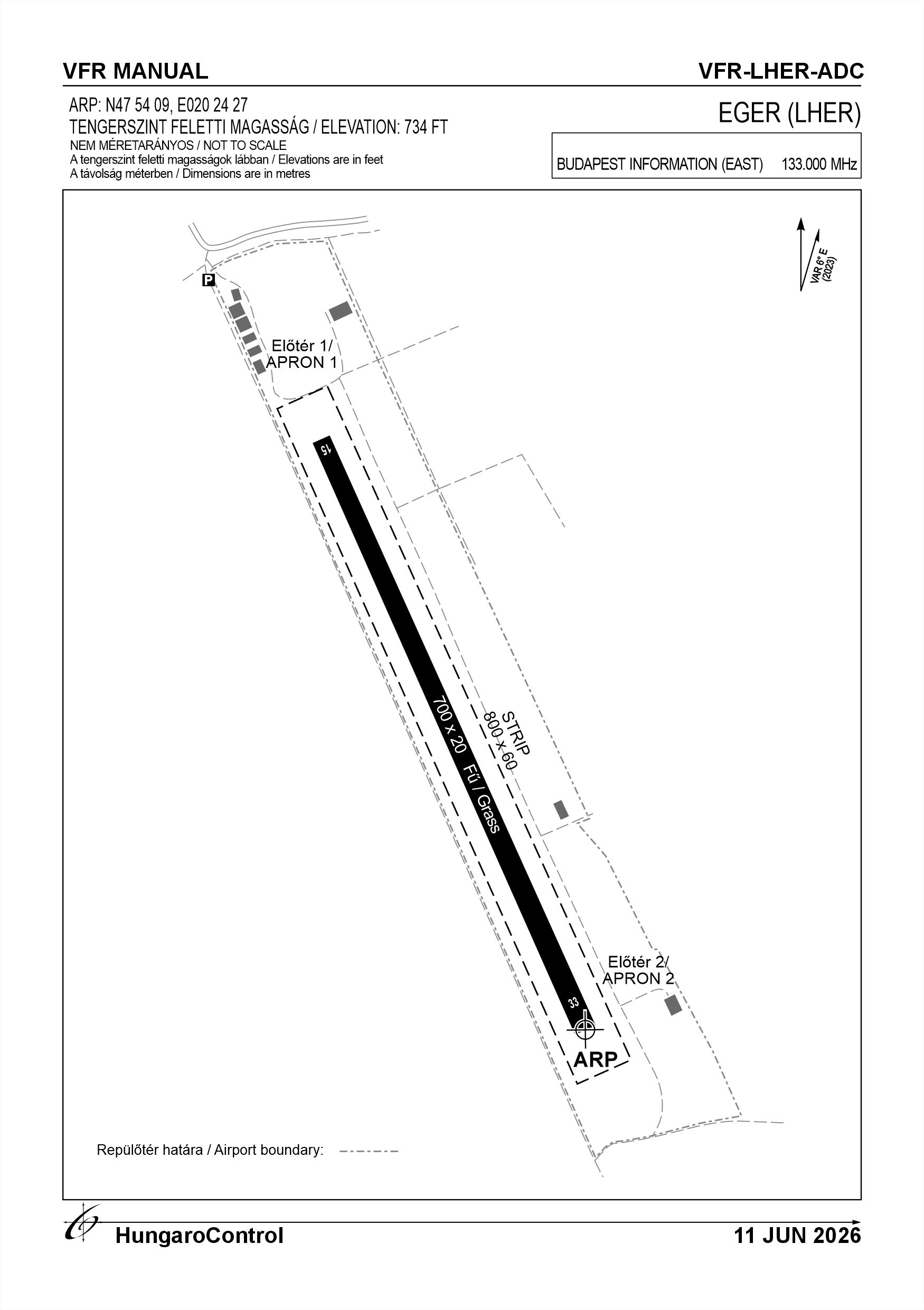
12. Aprons
|
Designation
|
Surface
|
Strength
|
Remarks
|
Designator
|
|---|---|---|---|---|
| E 1 | Grass | 5.5 t (2 t) | The airport operator can provide information on the condition of the apron on request. | NIL |
| E 2 | Grass | 5.5 t (2 t) | The airport operator can provide information on the condition of the apron on request. | NIL |
13. Taxiways
|
Designation
|
Surface
|
Strength
|
Width (M)
|
Remarks
|
Designatior
|
|---|---|---|---|---|---|
| NIL | NIL | NIL | NIL | NIL | NIL |
14. Checkpoints
Altimeter checkpoints and locations data
- Coordinates
- NIL
- Technical data
- NIL
- VOR checkpoints
- NIL
- INS checkpoints
- NIL
- Remarks
- NIL
15. Surface movement guidance and control system and markings
- Use of aircraft stand ID signs, TWY guide lines and visual docking/parking guidance system of aircraft stands
- NIL
- RWY and TWY markings and lighting
-
RWY threshold signs, edge signs
Lighting: N/A
- Stop bars
- NIL
- Remarks
- NIL
16. Runways (RWY)
|
RWY designator
|
True bearing
|
Magnetic bearing
|
Length (M)
|
Width (M)
|
Strength
|
Surface
|
Remarks
|
|---|---|---|---|---|---|---|---|
| 15 | 157° | 151° | 700 | 20 | 5.5 t (2 t) | Grass | Information on the condition of the runway can be obtained from the operator on request. |
| 33 | 337° | 331° | 700 | 20 | 5.5 t (2 t) | Grass | Information on the condition of the runway can be obtained from the operator on request. |
17. Aerodrome obstacles
18. Stopways (SWY)
|
RWY designator
|
Length (M)
|
Width (M)
|
Strength
|
Surface
|
Slope (%)
|
Remarks
|
|---|---|---|---|---|---|---|
| 15 | NIL | NIL | NIL | NIL | NIL | NIL |
| 33 | NIL | NIL | NIL | NIL | NIL | NIL |
19. Clearways (CWY)
|
RWY designator
|
Length (M)
|
Width (M)
|
Slope (%)
|
Remarks
|
|---|---|---|---|---|
| 15 | NIL | NIL | NIL | NIL |
| 33 | NIL | NIL | NIL | NIL |
20. STRIP
|
RWY designator
|
Length (M)
|
Width (M)
|
Remarks
|
|---|---|---|---|
| 15 | 800 | 60 | Surface: Grass |
| 33 | 800 | 60 | Surface: Grass |
21. RESA
|
RWY designator
|
Length (M)
|
Width (M)
|
Surface
|
Obstacle free zone (OFZ)
|
Remarks
|
|---|---|---|---|---|---|
| 15 | NIL | NIL | NIL | NIL | NIL |
| 33 | NIL | NIL | NIL | NIL | NIL |
22. Declared distances
|
RWY designator
|
TORA (M)
|
TODA (M)
|
ASDA (M)
|
LDA (M)
|
Remarks
|
|---|---|---|---|---|---|
| 15 | 700 | 700 | 700 | 700 | NIL |
| 33 | 700 | 700 | 700 | 700 | NIL |
23. Approach lighting
|
RWY designator
|
Type
|
Length (M)
|
Intensity
|
Remarks
|
|---|---|---|---|---|
| 15 | NIL | NIL | NIL | NIL |
| 33 | NIL | NIL | NIL | NIL |
24. Threshold lighting
|
RWY designator
|
Colour
|
Wing bar lights
|
Remarks
|
|---|---|---|---|
| 15 | NIL | NIL | NIL |
| 33 | NIL | NIL | NIL |
25. Visual approach slope indicator system lighting
|
RWY designator
|
Type
|
Data
|
Remarks
|
|---|---|---|---|
| 15 | NIL | NIL | NIL |
| 33 | NIL | NIL | NIL |
26. Touchdone zone lighting
|
RWY designator
|
Length of lighting (M)
|
Remarks
|
|---|---|---|
| 15 | NIL | NIL |
| 33 | NIL | NIL |
27. Runway centreline lighting
|
RWY designator
|
Length (M)
|
Spacing (M)
|
Colour
|
Intensity
|
Remarks
|
|---|---|---|---|---|---|
| 15 | NIL | NIL | NIL | NIL | NIL |
| 33 | NIL | NIL | NIL | NIL | NIL |
28. Runway edgeline lighting
|
RWY designator
|
Length (M)
|
Spacing (M)
|
Colour
|
Intensity
|
Remarks
|
|---|---|---|---|---|---|
| 15 | NIL | NIL | NIL | NIL | NIL |
| 33 | NIL | NIL | NIL | NIL | NIL |
29. Runway end lighting
|
RWY designator
|
Colour
|
Remarks
|
|---|---|---|
| 15 | NIL | NIL |
| 33 | NIL | NIL |
30. Runway wing bars lighting
|
RWY designator
|
Colour
|
Remarks
|
|---|---|---|
| 15 | NIL | NIL |
| 33 | NIL | NIL |
31. Stopway lighting
|
RWY designator
|
Length of lighting (M)
|
Colour
|
Remarks
|
|---|---|---|---|
| 15 | NIL | NIL | NIL |
| 33 | NIL | NIL | NIL |
32. Other lighting, secondary power supply
- ABN/IBN location, charasteristics and hours of operation
- NIL
- LDI location and lighting
- On top of the central hangar, lighting: N/A
- Anemometer location and lighting
- NIL
- 4Centre line lighting
- NIL
- TWY edge line lighting
- NIL
- Secondary power supply
- NIL
- Switch-over time
- NIL
- Remarks
- NIL
33. Helicopter landing area
- Coordinates TLOF or THR of FATO
- NIL
- TLOF and/or FATO elevation
- NIL
- TLOF and FATO area marking
- NIL
- TLOF and FATO area dimensions (M)
- NIL
- TLOF and FATO area surface
- NIL
- TLOF and FATO area strength
- NIL
- True BRG of FATO
- NIL
- MAG BRG of FATO
- NIL
- Declared distances available
- NIL
- APP and FATO lighting
- NIL
- Remarks
- NIL
34. Meteorological information provider
- Associated MET Office
- HungaroMet Magyar Meteorológiai Szolgáltató Nonprofit Zrt. (HungaroMet Zrt.), Unit of Aviation Meteorology
- Hours of service
- H24
- Office responsible for TAF preparation
- HungaroMet Magyar Meteorológiai Szolgáltató Nonprofit Zrt. (HungaroMet Zrt.), Unit of Aviation Meteorology
- Periods of validity
- NIL
- Interval of issuance
- NIL
- Type of landing forecast
- NIL
- Landing forecast interval of issuance
- NIL
- Briefing/consultation provided
- Written briefing: https://aviation.met.hu;Consultation via phone: +36-90/603-424;Consultation via e-mail: rvo@met.hu;
- Flight documentation
- Charts, abbreviated plain language text
- Language(s) used
- HU, EN
- Charts and other information available for briefing or consultation
- Charts, aerodrome reports and forecasts in EUR region, area forecasts, MET. observations and warnings in Budapest FIR
- Supplementary equipment available for providing information
- Self-briefing via aviation.met.hu
- ATS Units provided with information
- Budapest FIC (on request)
- Remarks
- NIL
35. Air traffic service airspace
- Designation
- NIL
- Lateral limits
- NIL
- Vertical limits (FT)
- NIL
- Airspace classification
- NIL
- ATS unit call sign
- NIL
- Languages used
- NIL
- Transition altitude (FT)
- NIL
- Remarks
- NIL
37. Local aerodrome regulations
See the Airport Rules.
Activities at the airport (Yes / No)
- Unmanned aerial vehicle (D)
- With a special operator's permit
- Ballon (B)
- Yes
- Ultralight (U)
- Yes
- Hang glider (N)
- Yes
- Short take-off and landing (R)
- Yes
- Landplane (L)
- Yes
- Paraglider (P)
- Yes
- Glider (G)
- Yes
- Amphibian (A)
- No
- Helicopter (H)
- Yes
- Gyrocopter (G)
- Yes
- Tilt-wing aircraft (T)
- Yes
- Other (O)
- NIL
38. Noise abatement procedures
See the Airport Rules.
39. Aerodrome charges
NIL
40. Additional information
For more information, see the Airport Rules.
41. Aerodrome obstacles
- No obstacle text
- NIL
- RWY designator
- NIL
- Obstacle type
- NIL
- Elevation
- NIL
- Height
- NIL
- Coordinates
- NIL
- Remarks
- NIL