LHBY Bőny Airport
Last updated: 2025.10.02.
1. Aerodrome identification
- Aerodrome location indicator
- LHBY
- Aerodrome name
- Bőny Airport
- Aerodrome place name
- Bőny
2. Contact
- Address
- 9073 Bőny, Purgly Puszta Repülőtér, hrsz: 0166/68
- Phone
- +36-70/886-1261
- info@flyby.hu
3. Gallery
Teljes képernyő
Teljes
képernyő bezárása

Teljes képernyő
Teljes
képernyő bezárása

Teljes képernyő
Teljes
képernyő bezárása

Teljes képernyő
Teljes
képernyő bezárása

Teljes képernyő
Teljes
képernyő bezárása
Teljes képernyő
Teljes
képernyő bezárása
5. Aerodrome geographical and administrative data
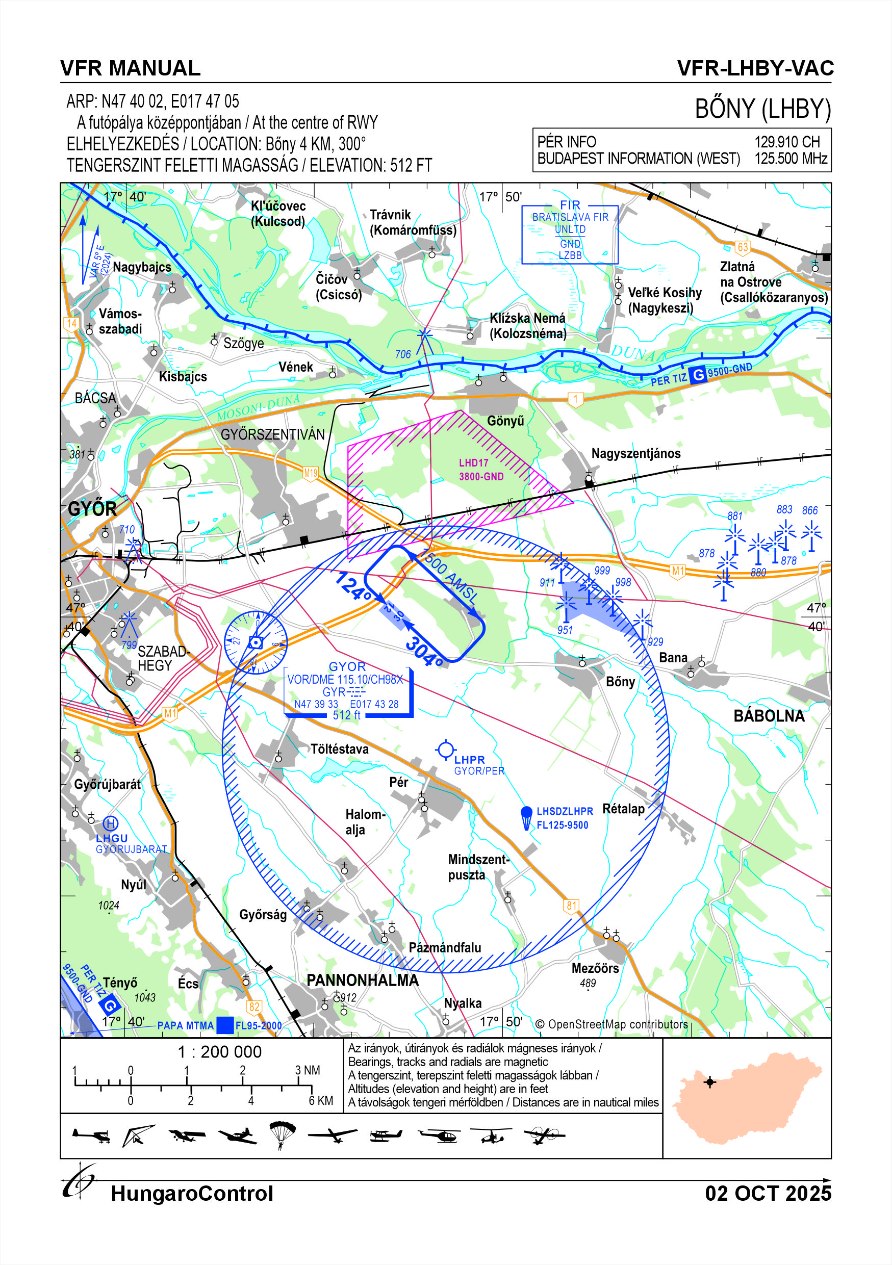
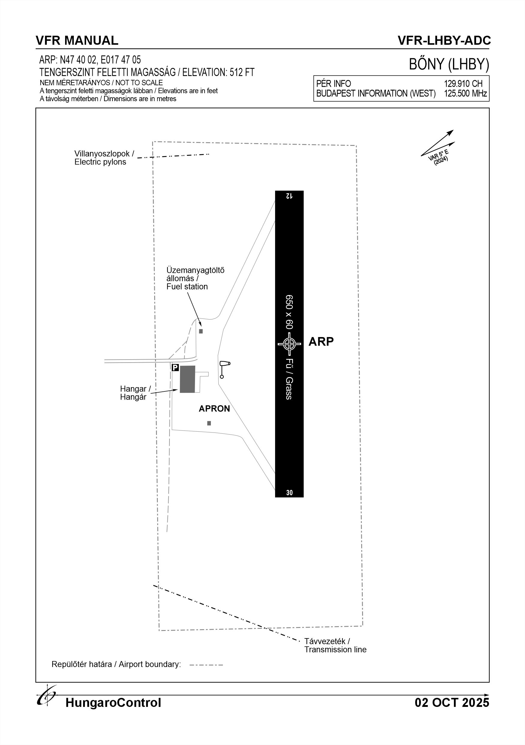
ARP data
- Coordinates
- 474002N 0174705E
- Site at aerodrome
- At the centre of the RWY
Location of aerodrome
- Distance from city (KM)
- Bőny 4 KM
- Direction from city
- 300°
- Elevation
- 512 FT
Magnetic variation data
- Degree of magnetic variation ( °)
- 5°29' E
- Annual change ( °)
- +0.9°
- Year of survey
- 2024
Aerodrome operator data
- Name
- Flyby-Aero Kft.
- Address
- 2040 Budaörs, Király u. 26/1
- Phone
- +36-70/886-1261
- Fax
- NIL
- Web
- https://flyby.hu
- info@flyby.hu
Aerodrome data
- Name
- 9073 Bőny, Purgly Puszta Repülőtér, hrsz: 0166/68
- Phone
- +36-20/326-6455 (Simon Martin)
- Fax
- NIL
- Web
- https://flyby.hu
- info@flyby.hu
- AFS
- NIL
- SITA
- NIL
- Others
- NIL
- Type of traffic allowed at the aerodrome
- VFR
- Remarks
- Special airport for civil use
- Responsible operator's name
- NIL
- Time logged
- NIL
6. Air traffic services communication facitlities
|
Service designation
|
Call sign
|
Channel
|
Languages used
|
Hours of operation
|
Remarks
|
|---|---|---|---|---|---|
| Pér Info | Pér Info | 129.910 CH | HU, EN | See AIP | The AFIS of LHPR TIZ not located at LHBY. Although the AFIS is not present at LHBY, two-way radio communication must be established with LHPR. |
7. Operation hours
- AD Administration
- Maximum sunrise between -30 minutes and maximum sunset +45 minutes, but not longer than dusk and twilight, whichever is longer, and in conditions suitable for VFR flights. In the event of a snow cover of more than 1 cm on the runway, the airport is closed.
- Customs and immigration
- NIL
- Health and sanitation
- First aid on spot
- AIS Briefing Office
- LHPR AFIS
- ATS Reporting Office (ARO)
- NIL
- MET Briefing Office
- NIL
- ATS
- NIL
- Fuelling
- For private use with local staff on request
- Handling
- NIL
- Security
- H24
- De-icing
- NIL
- Remarks
- Local AFIS service provided by LHPR airport
8. Available handling services and facilities
- Cargo-handling facilities
- NIL
- Fuel types
- AVGAS 100LL
- Oil types
- 15W50, W100
- Fuelling facilities and capacity
- 1000 litre mobile storage with filling head, pump and 3000 litre storage
- De-icing facilities
- NIL
- Hangar space for visiting aircraft
- 1 hangar of 800nm and 1 tent of 300nm
- Repair facilities for visiting aircraft
- On request
- Remarks
- NIL
9. Passenger facilities
- Hotels
- In the city
- Restaurants
- In the city
- Transportation
- Taxi and public transportation
- Medical facilities
- First aid at the airport, nearest hospital in Győr
- Bank and Post Office
- In the city
- Tourist Office
- In the city
- Remarks
- NIL
10. Available rescue and fire fighting services
- Aerodrome catogory for fire fighting
- Category 1 as defined in Annex 3 to Government Decree 85/2024 (IV.17). Only organisations authorised in writing may carry out economic activities
- Available rescue and fire fighting services
- 1 person with a fire safety qualification
- Rescue and fire fighting equipment
- Fire extinguishers and equipment in category 1 of Annex 3 of Government Decree 85/2024 (IV.17).
- Capability for removal of disabled aircraft
- Vehicle and small tools
- Remarks
- NIL
11. Clearing
- Types of clearing equipment
- NIL
- Clearance priorities
- NIL
- Remarks
- NIL
12. Aprons
|
Designation
|
Surface
|
Strength
|
Remarks
|
Designator
|
|---|---|---|---|---|
| NIL | NIL | NIL | NIL | NIL |
13. Taxiways
|
Designation
|
Surface
|
Strength
|
Width (M)
|
Remarks
|
Designatior
|
|---|---|---|---|---|---|
| NIL | NIL | NIL | NIL | NIL | NIL |
14. Checkpoints
Altimeter checkpoints and locations data
- Coordinates
- NIL
- Technical data
- NIL
- VOR checkpoints
- NIL
- INS checkpoints
- NIL
- Remarks
- NIL
15. Surface movement guidance and control system and markings
- Use of aircraft stand ID signs, TWY guide lines and visual docking/parking guidance system of aircraft stands
- NIL
- RWY and TWY markings and lighting
- RWY threshold signs, edge signs
- Stop bars
- NIL
- Remarks
- NIL
16. Runways (RWY)
|
RWY designator
|
True bearing
|
Magnetic bearing
|
Length (M)
|
Width (M)
|
Strength
|
Surface
|
Remarks
|
|---|---|---|---|---|---|---|---|
| 12 | 129° | 124° | 650 | 60 | 10 t (5.7 t) | Grass | The airport is only for use by helicopters under 5.7 t MTOW, except for Air Force helicopters. The operator may prohibit the movement of certain aircraft, depending on the wetness of the surface, and in the event of significant waterlogged, the operator shall close the aerodrome. |
| 30 | 309° | 304° | 650 | 60 | 10 t (5.7 t) | Grass | The airport is only for use by helicopters under 5.7 t MTOW, except for Air Force helicopters. The operator may prohibit the movement of certain aircraft, depending on the wetness of the surface, and in the event of significant waterlogged, the operator shall close the aerodrome. |
17. Aerodrome obstacles
|
RWY designator
|
Obstacle type
|
Elevation
|
Height
|
Coordinates
|
Remarks
|
|---|---|---|---|---|---|
| 12 | Transmission line | 530 FT | 18 FT | 473950N 0174728E | 130° and 1020 m from THR |
| 30 | Tree line | 522 FT | 10 FT | 4740116N 0174642E | 310° and 1020 m from THR |
| 30 | Electric pylon | 510 FT | 13 FT | 474007N 0174644E | 300° and 820 m from THR |
| 30 | Electric pylon | 510 FT | 13 FT | 474015N 0174654E | NIL |
18. Stopways (SWY)
|
RWY designator
|
Length (M)
|
Width (M)
|
Strength
|
Surface
|
Slope (%)
|
Remarks
|
|---|---|---|---|---|---|---|
| 12 | NIL | NIL | NIL | NIL | NIL | NIL |
| 30 | NIL | NIL | NIL | NIL | NIL | NIL |
19. Clearways (CWY)
|
RWY designator
|
Length (M)
|
Width (M)
|
Slope (%)
|
Remarks
|
|---|---|---|---|---|
| 12 | NIL | NIL | NIL | NIL |
| 30 | NIL | NIL | NIL | NIL |
20. STRIP
|
RWY designator
|
Length (M)
|
Width (M)
|
Remarks
|
|---|---|---|---|
| 12 | NIL | NIL | NIL |
| 30 | NIL | NIL | NIL |
21. RESA
|
RWY designator
|
Length (M)
|
Width (M)
|
Surface
|
Obstacle free zone (OFZ)
|
Remarks
|
|---|---|---|---|---|---|
| 12 | NIL | NIL | NIL | NIL | NIL |
| 30 | NIL | NIL | NIL | NIL | NIL |
22. Declared distances
|
RWY designator
|
TORA (M)
|
TODA (M)
|
ASDA (M)
|
LDA (M)
|
Remarks
|
|---|---|---|---|---|---|
| 12 | 650 | 725 | 725 | 650 | NIL |
| 30 | 650 | 725 | 725 | 650 | NIL |
23. Approach lighting
|
RWY designator
|
Type
|
Length (M)
|
Intensity
|
Remarks
|
|---|---|---|---|---|
| 12 | NIL | NIL | NIL | NIL |
| 30 | NIL | NIL | NIL | NIL |
24. Threshold lighting
|
RWY designator
|
Colour
|
Wing bar lights
|
Remarks
|
|---|---|---|---|
| 12 | NIL | NIL | NIL |
| 30 | NIL | NIL | NIL |
25. Visual approach slope indicator system lighting
|
RWY designator
|
Type
|
Data
|
Remarks
|
|---|---|---|---|
| 12 | NIL | NIL | NIL |
| 30 | NIL | NIL | NIL |
26. Touchdone zone lighting
|
RWY designator
|
Length of lighting (M)
|
Remarks
|
|---|---|---|
| 12 | NIL | NIL |
| 30 | NIL | NIL |
27. Runway centreline lighting
|
RWY designator
|
Length (M)
|
Spacing (M)
|
Colour
|
Intensity
|
Remarks
|
|---|---|---|---|---|---|
| 12 | NIL | NIL | NIL | NIL | NIL |
| 30 | NIL | NIL | NIL | NIL | NIL |
28. Runway edgeline lighting
|
RWY designator
|
Length (M)
|
Spacing (M)
|
Colour
|
Intensity
|
Remarks
|
|---|---|---|---|---|---|
| 12 | NIL | NIL | NIL | NIL | NIL |
| 30 | NIL | NIL | NIL | NIL | NIL |
29. Runway end lighting
|
RWY designator
|
Colour
|
Remarks
|
|---|---|---|
| 12 | NIL | NIL |
| 30 | NIL | NIL |
30. Runway wing bars lighting
|
RWY designator
|
Colour
|
Remarks
|
|---|---|---|
| 12 | NIL | NIL |
| 30 | NIL | NIL |
31. Stopway lighting
|
RWY designator
|
Length of lighting (M)
|
Colour
|
Remarks
|
|---|---|---|---|
| 12 | NIL | NIL | NIL |
| 30 | NIL | NIL | NIL |
32. Other lighting, secondary power supply
- ABN/IBN location, charasteristics and hours of operation
- NIL
- LDI location and lighting
- NIL
- Anemometer location and lighting
- NIL
- 4Centre line lighting
- NIL
- TWY edge line lighting
- NIL
- Secondary power supply
- NIL
- Switch-over time
- NIL
- Remarks
- NIL
33. Helicopter landing area
- Coordinates TLOF or THR of FATO
- NIL
- TLOF and/or FATO elevation
- NIL
- TLOF and FATO area marking
- NIL
- TLOF and FATO area dimensions (M)
- NIL
- TLOF and FATO area surface
- NIL
- TLOF and FATO area strength
- NIL
- True BRG of FATO
- NIL
- MAG BRG of FATO
- NIL
- Declared distances available
- NIL
- APP and FATO lighting
- NIL
- Remarks
- NIL
34. Meteorological information provider
- Associated MET Office
- HungaroMet Magyar Meteorológiai Szolgáltató Nonprofit Zrt. (HungaroMet Zrt.), Unit of Aviation Meteorology
- Hours of service
- H24
- Office responsible for TAF preparation
- HungaroMet Magyar Meteorológiai Szolgáltató Nonprofit Zrt. (HungaroMet Zrt.), Unit of Aviation Meteorology
- Periods of validity
- NIL
- Interval of issuance
- NIL
- Type of landing forecast
- NIL
- Landing forecast interval of issuance
- NIL
- Briefing/consultation provided
- Written briefing: https://aviation.met.hu;Consultation via phone: +36-90/603-424;Consultation via e-mail: rvo@met.hu;
- Flight documentation
- Charts, abbreviated plain language text
- Language(s) used
- HU, EN
- Charts and other information available for briefing or consultation
- Charts, aerodrome reports and forecasts in EUR region, area forecasts, MET. observations and warnings in Budapest FIR
- Supplementary equipment available for providing information
- Self-briefing via aviation.met.hu
- ATS Units provided with information
- Budapest FIC (on request)
- Remarks
- NIL
35. Air traffic service airspace
- Designation
- Pér TIZ
- Lateral limits
- 474906N 0173651E - 474449N 0173000E - 473559N 0172918E - 473559N 0173554E - 472959N 0174154E - 472959N 0180954E - 473521N 0181527E - 474419N 0181530E Államhatár mentén Magyarország-Szlovákia - 474906N 0173651E
- Vertical limits (FT)
- GND - 9500 FT AMSL
- Airspace classification
- G
- ATS unit call sign
- Pér Info
- Languages used
- HU, EN
- Transition altitude (FT)
- NIL
- Remarks
- Flights with established 2 way radio communication and transponder usage
37. Local aerodrome regulations
Aerodrome Bőny is located under LHPR Airport TIZ provided with AFIS service. According actual regulations flying in TIZ requires 2 way radio communication and transponder usage. Flights into and out of the TIZ are flightplan mandatory movements. To fill a flightplan is not mandatory during local flights at Bőny, but leaving the TIZ will become a mandatory flightplan phase (eg: cross-country flight). Type of flight, and mutual information support has to be provided for Pér AFIS all the time, therefore:- Since the departure at Bőny enters the TIZ of Pér, the pilot must inform Pér AFIS about the start up and type of flight (eg: local flight, traffic circuit, etc.).- Pilot must maintain during the hall flight the 2 way radio communication on 129.910 MHz.- Pilot must inform AFIS service about the finish of the flight.- The leave of the above mentioned frequency must be reported all the time.Type of flights at Bőny aerodrome:- Local flights (eg: instructing flights, practice, test flights, etc.).- Cross-country flights.- Aerobatic flights (According Pér airport manual AOM II. 10. ) in relation with regulation 56/2016 XII.22. NFM- Parashute dropping exercises.Runway 12 in use: left hand traffic circuit, altitude 1500 feet AMSL. With approval from Pér AFIS, if traffic permits right hand circuit can be used as well. Runway 30 in use: right hand traffic circuit, altitude 1500 feet AMSL. With approval from Pér AFIS, if traffic permits left hand circuit can be used as well. Changes (direction, altitude) in the prescribed circuits can be only done with approval from Pér AFIS service. Pilots at Bőny aerodrome must maintain own separation during movements (ground roll, flight in the air) with help of Pér AFIS service. For more information, see the Airport Rules.
Activities at the airport (Yes / No)
- Unmanned aerial vehicle (D)
- No
- Ballon (B)
- No
- Ultralight (U)
- Yes
- Hang glider (N)
- Yes
- Short take-off and landing (R)
- Yes
- Landplane (L)
- Yes
- Paraglider (P)
- Yes
- Glider (G)
- Yes
- Amphibian (A)
- Yes
- Helicopter (H)
- Yes
- Gyrocopter (G)
- Yes
- Tilt-wing aircraft (T)
- Yes
- Other (O)
- Yes
38. Noise abatement procedures
Whenever possible, it is recommended to avoid Győrszentiván, Bőny and Szőlőhegy when flying on the school circuit. Noise protection zones are not necessary due to the low traffic volume.
39. Aerodrome charges
No landing fee, for aircraft storage please call: +36-70/886-1261.
40. Additional information
Radio usage is mandatory on 129.910 MHz, or on the local FIC frequency when flying outside of Pér AFIS operation times.For more information, see the Airport Rules.
41. Aerodrome obstacles
- No obstacle text
- NIL
- RWY designator
- NIL
- Obstacle type
- NIL
- Elevation
- NIL
- Height
- NIL
- Coordinates
- NIL
- Remarks
- NIL