LHAK Atkár-Gyöngyöshalász Airport
Last updated: 2025.11.27.
1. Aerodrome identification
- Aerodrome location indicator
- LHAK
- Aerodrome name
- Atkár-Gyöngyöshalász Airport
- Aerodrome place name
- Atkár
2. Contact
- Address
- 3212 Gyöngyöshalász, Encspuszta-Repülőtér hrsz: 0178/46
- Phone
- +36-30/935-2045
- encspuszta@gmail.com
3. Gallery
Teljes képernyő
Teljes
képernyő bezárása

Teljes képernyő
Teljes
képernyő bezárása

Teljes képernyő
Teljes
képernyő bezárása

Teljes képernyő
Teljes
képernyő bezárása

Teljes képernyő
Teljes
képernyő bezárása

Teljes képernyő
Teljes
képernyő bezárása

Teljes képernyő
Teljes
képernyő bezárása
Teljes képernyő
Teljes
képernyő bezárása
5. Aerodrome geographical and administrative data
ARP data
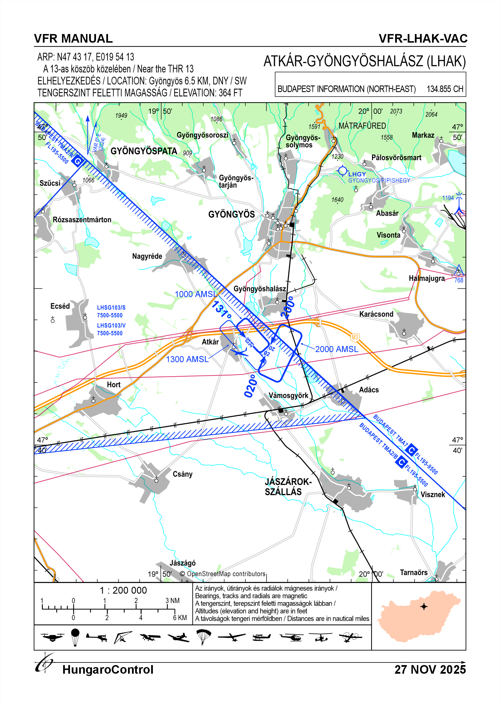
- Coordinates
- 474317N 0195413E
- Site at aerodrome
- Near the THR 13
Location of aerodrome
- Distance from city (KM)
- Gyöngyös 6.5 KM
- Direction from city
- SW
- Elevation
- 364 FT
Magnetic variation data
- Degree of magnetic variation ( °)
- 5°55' E
- Annual change ( °)
- +0°08'
- Year of survey
- 2024
Aerodrome operator data
- Name
- Molnár Csaba
- Address
- 3231 Gyöngyössolymos, Kiss Ignác út 19.
- Phone
- +36-30/935-2045
- Fax
- NIL
- Web
- NIL
- fireelectric@freemail.hu
Aerodrome data
- Name
- 3212 Gyöngyöshalász, Encspuszta-Repülőtér hrsz: 0178/46
- Phone
- +36-30/935-2045 (Molnár Csaba)
- Fax
- NIL
- Web
- NIL
- encspuszta@gmail.com
- AFS
- NIL
- SITA
- NIL
- Others
- NIL
- Type of traffic allowed at the aerodrome
- VFR
- Remarks
- Special airport for civil use
- Responsible operator's name
- NIL
- Time logged
- NIL
6. Air traffic services communication facitlities
|
Service designation
|
Call sign
|
Channel
|
Languages used
|
Hours of operation
|
Remarks
|
|---|---|---|---|---|---|
| NIL | NIL | NIL | NIL | NIL | NIL |
7. Operation hours
- AD Administration
- SR - SS, in VFR conditions, on snow-free days
- Customs and immigration
- NIL
- Health and sanitation
- NIL
- AIS Briefing Office
- NIL
- ATS Reporting Office (ARO)
- NIL
- MET Briefing Office
- NIL
- ATS
- NIL
- Fuelling
- NIL
- Handling
- NIL
- Security
-
H24
Area monitored by camera
- De-icing
- NIL
- Remarks
- NIL
8. Available handling services and facilities
- Cargo-handling facilities
- NIL
- Fuel types
- NIL
- Oil types
- NIL
- Fuelling facilities and capacity
- NIL
- De-icing facilities
- NIL
- Hangar space for visiting aircraft
- For private use only
- Repair facilities for visiting aircraft
- NIL
- Remarks
- NIL
9. Passenger facilities
- Hotels
- In the city
- Restaurants
- In the city
- Transportation
- Taxi, Bus
- Medical facilities
- In the city
- Bank and Post Office
- In the city
- Tourist Office
- In the city
- Remarks
- Nincs
10. Available rescue and fire fighting services
- Aerodrome catogory for fire fighting
- Category 1 as defined in Annex 3 to Government Decree 85/2024 (IV.17)
- Available rescue and fire fighting services
- NIL
- Rescue and fire fighting equipment
- Fire extinguishers and equipment in category 1 of Annex 3 of Government Decree 85/2024 (IV.17)
- Capability for removal of disabled aircraft
- NIL
- Remarks
- NIL
11. Clearing
- Types of clearing equipment
- NIL
- Clearance priorities
- NIL
- Remarks
- The airport operates only on snow-free days.
12. Aprons
|
Designation
|
Surface
|
Strength
|
Remarks
|
Designator
|
|---|---|---|---|---|
| NIL | NIL | NIL | NIL | NIL |
13. Taxiways
|
Designation
|
Surface
|
Strength
|
Width (M)
|
Remarks
|
Designatior
|
|---|---|---|---|---|---|
| NIL | NIL | NIL | NIL | NIL | NIL |
14. Checkpoints
Altimeter checkpoints and locations data
- Coordinates
- NIL
- Technical data
- NIL
- VOR checkpoints
- NIL
- INS checkpoints
- NIL
- Remarks
- NIL
15. Surface movement guidance and control system and markings
- Use of aircraft stand ID signs, TWY guide lines and visual docking/parking guidance system of aircraft stands
- NIL
- RWY and TWY markings and lighting
- RWY threshold signs, edge signs
- Stop bars
- NIL
- Remarks
- NIL
16. Runways (RWY)
|
RWY designator
|
True bearing
|
Magnetic bearing
|
Length (M)
|
Width (M)
|
Strength
|
Surface
|
Remarks
|
|---|---|---|---|---|---|---|---|
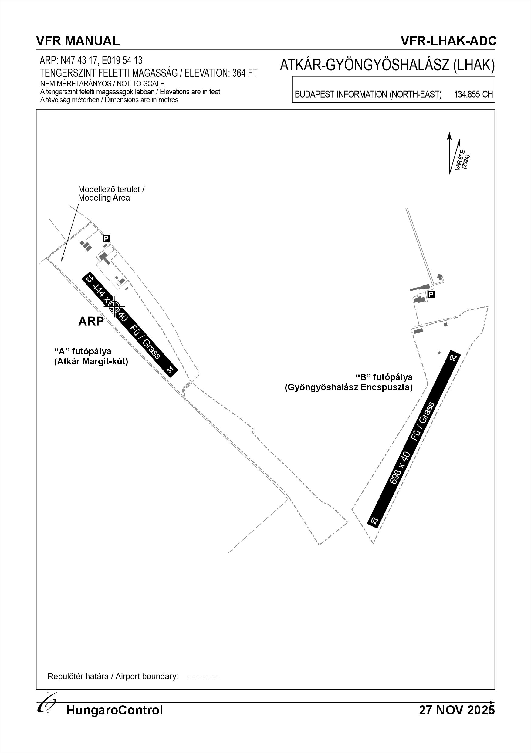
| 13 | 137° | 131° | 444 | 40 | 6 t (2 t) | Grass | For landing only |
| 31 | 317° | 311° | 444 | 40 | 6 t (2 t) | Grass | For take-off only |
| 02 | 026° | 020° | 698 | 40 | 6 t (2 t) | Grass | NIL |
| 20 | 206° | 200° | 698 | 40 | 6 t (2 t) | Grass | NIL |
17. Aerodrome obstacles
|
RWY designator
|
Obstacle type
|
Elevation
|
Height
|
Coordinates
|
Remarks
|
|---|---|---|---|---|---|
| 31 | Tower | 429.79 FT | 65.62 FT | 474336.31N 0195403.22E | In the direction of the RWY centre line |
| 31 | Transmission line | 396.98 FT | 32.81 FT | 474333.38N 0195355.58E | 20 kW transmission line |
| 31 | Tree line | 419.95 FT | 55.78 FT | 474331.77N 0195356.43E | Tree line in the direction of the RWY centre line |
| 31 | Tree line | 429.79 FT | 65.62 FT | 474307.90N 0195428.98E | Tree line next to the RWY |
| 02 | Trees | 413.39 FT | 49.22 FT | 474317.18N 0195513.44E | A group of trees around a lake |
18. Stopways (SWY)
|
RWY designator
|
Length (M)
|
Width (M)
|
Strength
|
Surface
|
Slope (%)
|
Remarks
|
|---|---|---|---|---|---|---|
| 13 | NIL | NIL | NIL | NIL | NIL | NIL |
| 31 | NIL | NIL | NIL | NIL | NIL | NIL |
| 02 | NIL | NIL | NIL | NIL | NIL | NIL |
| 20 | NIL | NIL | NIL | NIL | NIL | NIL |
19. Clearways (CWY)
|
RWY designator
|
Length (M)
|
Width (M)
|
Slope (%)
|
Remarks
|
|---|---|---|---|---|
| 13 | NIL | NIL | NIL | NIL |
| 31 | NIL | NIL | NIL | NIL |
| 02 | NIL | NIL | NIL | NIL |
| 20 | NIL | NIL | NIL | NIL |
20. STRIP
|
RWY designator
|
Length (M)
|
Width (M)
|
Remarks
|
|---|---|---|---|
| 13 | NIL | NIL | NIL |
| 31 | NIL | NIL | NIL |
| 02 | NIL | NIL | NIL |
| 20 | NIL | NIL | NIL |
21. RESA
|
RWY designator
|
Length (M)
|
Width (M)
|
Surface
|
Obstacle free zone (OFZ)
|
Remarks
|
|---|---|---|---|---|---|
| 13 | NIL | NIL | NIL | NIL | NIL |
| 31 | NIL | NIL | NIL | NIL | NIL |
| 02 | NIL | NIL | NIL | NIL | NIL |
| 20 | NIL | NIL | NIL | NIL | NIL |
22. Declared distances
|
RWY designator
|
TORA (M)
|
TODA (M)
|
ASDA (M)
|
LDA (M)
|
Remarks
|
|---|---|---|---|---|---|
| 13 | NIL | NIL | NIL | 444 | For landing only |
| 31 | 444 | 444 | 444 | NIL | For take-off only |
| 02 | 698 | 698 | 698 | 698 | NIL |
| 20 | 698 | 698 | 698 | 698 | NIL |
23. Approach lighting
|
RWY designator
|
Type
|
Length (M)
|
Intensity
|
Remarks
|
|---|---|---|---|---|
| 13 | NIL | NIL | NIL | NIL |
| 31 | NIL | NIL | NIL | NIL |
| 02 | NIL | NIL | NIL | NIL |
| 20 | NIL | NIL | NIL | NIL |
24. Threshold lighting
|
RWY designator
|
Colour
|
Wing bar lights
|
Remarks
|
|---|---|---|---|
| 13 | NIL | NIL | NIL |
| 31 | NIL | NIL | NIL |
| 02 | NIL | NIL | NIL |
| 20 | NIL | NIL | NIL |
25. Visual approach slope indicator system lighting
|
RWY designator
|
Type
|
Data
|
Remarks
|
|---|---|---|---|
| 13 | NIL | NIL | NIL |
| 31 | NIL | NIL | NIL |
| 02 | NIL | NIL | NIL |
| 20 | NIL | NIL | NIL |
26. Touchdone zone lighting
|
RWY designator
|
Length of lighting (M)
|
Remarks
|
|---|---|---|
| 13 | NIL | NIL |
| 31 | NIL | NIL |
| 02 | NIL | NIL |
| 20 | NIL | NIL |
27. Runway centreline lighting
|
RWY designator
|
Length (M)
|
Spacing (M)
|
Colour
|
Intensity
|
Remarks
|
|---|---|---|---|---|---|
| 13 | NIL | NIL | NIL | NIL | NIL |
| 31 | NIL | NIL | NIL | NIL | NIL |
| 02 | NIL | NIL | NIL | NIL | NIL |
| 20 | NIL | NIL | NIL | NIL | NIL |
28. Runway edgeline lighting
|
RWY designator
|
Length (M)
|
Spacing (M)
|
Colour
|
Intensity
|
Remarks
|
|---|---|---|---|---|---|
| 13 | NIL | NIL | NIL | NIL | NIL |
| 31 | NIL | NIL | NIL | NIL | NIL |
| 02 | NIL | NIL | NIL | NIL | NIL |
| 20 | NIL | NIL | NIL | NIL | NIL |
29. Runway end lighting
|
RWY designator
|
Colour
|
Remarks
|
|---|---|---|
| 13 | NIL | NIL |
| 31 | NIL | NIL |
| 02 | NIL | NIL |
| 20 | NIL | NIL |
30. Runway wing bars lighting
|
RWY designator
|
Colour
|
Remarks
|
|---|---|---|
| 13 | NIL | NIL |
| 31 | NIL | NIL |
| 02 | NIL | NIL |
| 20 | NIL | NIL |
31. Stopway lighting
|
RWY designator
|
Length of lighting (M)
|
Colour
|
Remarks
|
|---|---|---|---|
| 13 | NIL | NIL | NIL |
| 31 | NIL | NIL | NIL |
| 02 | NIL | NIL | NIL |
| 20 | NIL | NIL | NIL |
32. Other lighting, secondary power supply
- ABN/IBN location, charasteristics and hours of operation
- NIL
- LDI location and lighting
- NIL
- Anemometer location and lighting
- NIL
- 4Centre line lighting
- NIL
- TWY edge line lighting
- NIL
- Secondary power supply
- NIL
- Switch-over time
- NIL
- Remarks
- NIL
33. Helicopter landing area
- Coordinates TLOF or THR of FATO
- NIL
- TLOF and/or FATO elevation
- NIL
- TLOF and FATO area marking
- NIL
- TLOF and FATO area dimensions (M)
- NIL
- TLOF and FATO area surface
- NIL
- TLOF and FATO area strength
- NIL
- True BRG of FATO
- NIL
- MAG BRG of FATO
- NIL
- Declared distances available
- NIL
- APP and FATO lighting
- NIL
- Remarks
- NIL
34. Meteorological information provider
- Associated MET Office
- HungaroMet Magyar Meteorológiai Szolgáltató Nonprofit Zrt. (HungaroMet Zrt.), Unit of Aviation Meteorology
- Hours of service
- H24
- Office responsible for TAF preparation
- HungaroMet Magyar Meteorológiai Szolgáltató Nonprofit Zrt. (HungaroMet Zrt.), Unit of Aviation Meteorology
- Periods of validity
- NIL
- Interval of issuance
- NIL
- Type of landing forecast
- NIL
- Landing forecast interval of issuance
- NIL
- Briefing/consultation provided
- Written briefing: https://aviation.met.hu;Consultation via phone: +36-90/603-424;Consultation via e-mail: rvo@met.hu;
- Flight documentation
- Charts, abbreviated plain language text
- Language(s) used
- HU, EN
- Charts and other information available for briefing or consultation
- Charts, aerodrome reports and forecasts in EUR region, area forecasts, MET. observations and warnings in Budapest FIR
- Supplementary equipment available for providing information
- Self-briefing via aviation.met.hu
- ATS Units provided with information
- Budapest FIC (on request)
- Remarks
- NIL
35. Air traffic service airspace
- Designation
- NIL
- Lateral limits
- NIL
- Vertical limits (FT)
- NIL
- Airspace classification
- NIL
- ATS unit call sign
- NIL
- Languages used
- NIL
- Transition altitude (FT)
- NIL
- Remarks
- NIL
37. Local aerodrome regulations
The Airport has two runways. The west side has runways 13-31 and the east side has runways 02-20. The activities that can be performed at the airport together are: glider, (towed, beaked and self-launched), hang glider, UL, powered. Hot-air ballooning and ballooning activities can be separated in time. Separately in space, RC model aircraft activity may be conducted in the area at threshold 13 and simultaneously at a maximum distance of 200 m from threshold 31. Paragliding activities may be conducted. In the case of flying operations on any runway, the adjacent runway shall be shall be notified by telephone or in person 1 hour before the commencement of the flight. If the notification fails for any reason, the operator of the current runway shall the person responsible for the operation to be held at the current operating point must personally ensure that the other the other runway is clear of any flying activity. Crossing the M3 motorway and flying north of it below 150 m /500 ft AGL is prohibited. In the event that there are only two types of aircraft operations at the airport, they will always fly school circuits in opposite directions. In addition to powered aircraft and sailplanes, unpowered aircraft may fly school circles in the same direction as sailplanes, while powered/assisted aircraft may fly school circles in the same direction as powered aircraft. Modelling activities may only be conducted in a designated area near runway 13-31 up to 120 metres in height. In the case of a flying operation, the participants in the modelling operation must have radio contact. Model flights shall be stopped, aircraft departures and arrivals shall be the arrival and departure of aircraft. Model aircraft are NOT allowed to fly over facilities or parked aircraft. Only aircraft the commander of which has received permission from the operator or owners, or their designate, to use the aerodrome may use the aerodrome. The coordination of daily operations shall be organised on a day-to-day basis by the accountable manager or his/her deputy, depending on the weather and the operation or operations. The operator shall endeavour to keep wild animals out, but their presence cannot be excluded. Only VFR flights are allowed on the airport. For further information, please consult the current Airport Rules.
Activities at the airport (Yes / No)
- Unmanned aerial vehicle (D)
- Yes
- Ballon (B)
- Yes
- Ultralight (U)
- Yes
- Hang glider (N)
- Yes
- Short take-off and landing (R)
- Yes
- Landplane (L)
- Yes
- Paraglider (P)
- Yes
- Glider (G)
- Yes
- Amphibian (A)
- Yes
- Helicopter (H)
- Yes
- Gyrocopter (G)
- Yes
- Tilt-wing aircraft (T)
- Yes
- Other (O)
- NIL
38. Noise abatement procedures
No flights are allowed above 500m, below 1650' AMSL above surrounding settlements. Practical flight training, calibration flights shall be conducted with the minimum possible ambient noise exposure during daylight hours. In order to reduce noise from ground operations, engine running at idle, operation of auxiliary power units, operation of various charging aggregators, engine testing during maintenance shall only be carried out outside rest periods with the permission of the operator.
39. Aerodrome charges
There is no fee.
40. Additional information
For more information, see the Airport Rules.
41. Aerodrome obstacles
- No obstacle text
- NIL
- RWY designator
- NIL
- Obstacle type
- NIL
- Elevation
- NIL
- Height
- NIL
- Coordinates
- NIL
- Remarks
- NIL