- Zirc-Tündérmajor Airport
Last updated: 2025.08.07.
1. Aerodrome identification
- Aerodrome location indicator
- -
- Aerodrome name
- Zirc-Tündérmajor Airport
- Aerodrome place name
- Zirc
2. Contact
- Address
- 8420 Zirc, hrsz.: 0176
- Phone
- +36-30/931-1154, +36-70/339-9911
- bakonyfly@gmail.com
3. Gallery
Teljes képernyő
Teljes
képernyő bezárása
5. Aerodrome geographical and administrative data
ARP data
- Coordinates
- 471523N 0175012E
- Site at aerodrome
- At the THR 02
Location of aerodrome
- Distance from city (KM)
- Zirc 2.5 KM
- Direction from city
- 262°
- Elevation
- 1596 FT
Magnetic variation data
- Degree of magnetic variation ( °)
- 5°00' E
- Annual change ( °)
- +0°06'
- Year of survey
- 2023
Aerodrome operator data
- Name
- Sipos László Jenő, Bakonyfly Mentő és Kutató Egyesület
- Address
- 8420 Zirc, Kápolna utca 23., Posta: 8420 Zirc, Hrsz. 0176.
- Phone
- +36-30/931-1154, +36-70/339-9911
- Fax
- NIL
- Web
- NIL
- bakonyfly@gmail.com
Aerodrome data
- Name
- 8420 Zirc, hrsz.: 0176
- Phone
- +36-30/931-1154 (Sipos László Jenő), +36-30/886-5944 (Nemes István)
- Fax
- NIL
- Web
- NIL
- bakonyfly@gmail.com
- AFS
- NIL
- SITA
- NIL
- Others
- NIL
- Type of traffic allowed at the aerodrome
- VFR
- Remarks
- Special airport for civil use, Only PPR
- Responsible operator's name
- NIL
- Time logged
- NIL
6. Air traffic services communication facitlities
|
Service designation
|
Call sign
|
Channel
|
Languages used
|
Hours of operation
|
Remarks
|
|---|---|---|---|---|---|
| NIL | NIL | NIL | NIL | NIL | NIL |
7. Operation hours
- AD Administration
- With the prior permission of the operatorSR - SS
- Customs and immigration
- NIL
- Health and sanitation
- NIL
- AIS Briefing Office
- NIL
- ATS Reporting Office (ARO)
- NIL
- MET Briefing Office
- NIL
- ATS
- NIL
- Fuelling
- NIL
- Handling
- NIL
- Security
- NIL
- De-icing
- NIL
- Remarks
- NIL
8. Available handling services and facilities
- Cargo-handling facilities
- NIL
- Fuel types
- NIL
- Oil types
- NIL
- Fuelling facilities and capacity
- NIL
- De-icing facilities
- NIL
- Hangar space for visiting aircraft
- By agreement with the operator
- Repair facilities for visiting aircraft
- NIL
- Remarks
- NIL
9. Passenger facilities
- Hotels
- NIL
- Restaurants
- NIL
- Transportation
- NIL
- Medical facilities
- NIL
- Bank and Post Office
- NIL
- Tourist Office
- NIL
- Remarks
- NIL
10. Available rescue and fire fighting services
- Aerodrome catogory for fire fighting
- Category 1 as defined in Annex 3 to Government Decree 85/2024 (IV.17).
- Available rescue and fire fighting services
- NIL
- Rescue and fire fighting equipment
- 1 general ladder (for rescue) 1 box of AIDS gloves 1 95 cm crowbar 1 heavy-duty hacksaw with spare blades 1 axe 1 1.8 kg hammer 1 shovel or 1 shovel and 1 shovel 1 pair of 1.6 cm cutting edge pliers 1 20 cm combination pliers 1 25 cm pipe/water pump pliers 1 first aid kit for category "C" vehicles 6 pieces of 27/A 144B powder extinguishers (6 x 6kg)
- Capability for removal of disabled aircraft
- Tractor
- Remarks
- NIL
11. Clearing
- Types of clearing equipment
- NIL
- Clearance priorities
- NIL
- Remarks
- NIL
12. Aprons
|
Designation
|
Surface
|
Strength
|
Remarks
|
Designator
|
|---|---|---|---|---|
| NIL | NIL | NIL | NIL | NIL |
13. Taxiways
|
Designation
|
Surface
|
Strength
|
Width (M)
|
Remarks
|
Designatior
|
|---|---|---|---|---|---|
| NIL | NIL | NIL | NIL | NIL | NIL |
14. Checkpoints
Altimeter checkpoints and locations data
- Coordinates
- NIL
- Technical data
- NIL
- VOR checkpoints
- NIL
- INS checkpoints
- NIL
- Remarks
- NIL
15. Surface movement guidance and control system and markings
- Use of aircraft stand ID signs, TWY guide lines and visual docking/parking guidance system of aircraft stands
- NIL
- RWY and TWY markings and lighting
- RWY threshold signs, edge signs
- Stop bars
- NIL
- Remarks
- NIL
16. Runways (RWY)
|
RWY designator
|
True bearing
|
Magnetic bearing
|
Length (M)
|
Width (M)
|
Strength
|
Surface
|
Remarks
|
|---|---|---|---|---|---|---|---|
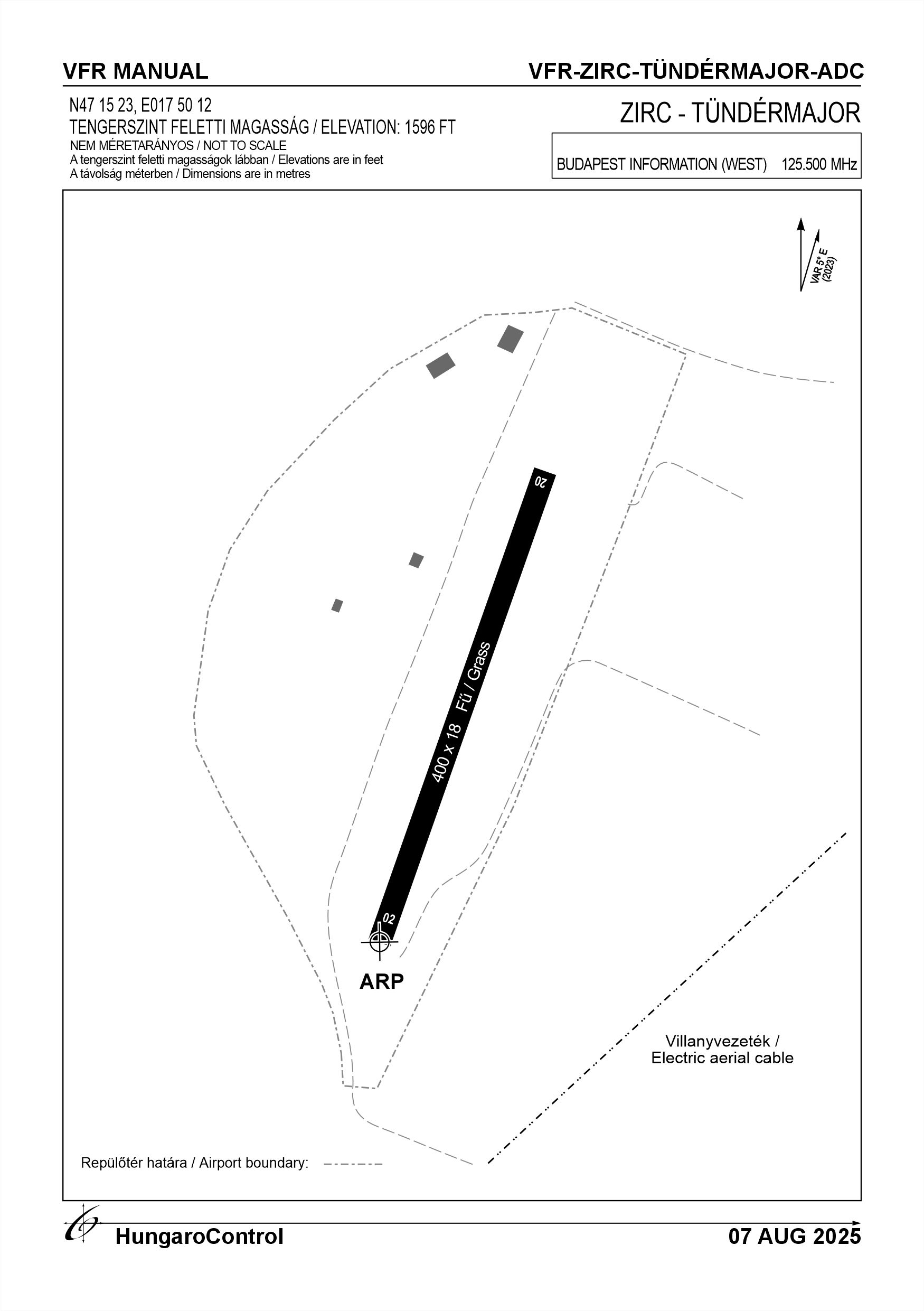
| 02 | 029° | 024° | 400 | 18 | 10 t (6 t) | Grass | NIL |
| 20 | 209° | 204° | 400 | 18 | 10 t (6 t) | Grass | NIL |
17. Aerodrome obstacles
18. Stopways (SWY)
|
RWY designator
|
Length (M)
|
Width (M)
|
Strength
|
Surface
|
Slope (%)
|
Remarks
|
|---|---|---|---|---|---|---|
| 02 | NIL | NIL | NIL | NIL | NIL | NIL |
| 20 | NIL | NIL | NIL | NIL | NIL | NIL |
19. Clearways (CWY)
|
RWY designator
|
Length (M)
|
Width (M)
|
Slope (%)
|
Remarks
|
|---|---|---|---|---|
| 02 | NIL | NIL | NIL | NIL |
| 20 | NIL | NIL | NIL | NIL |
20. STRIP
|
RWY designator
|
Length (M)
|
Width (M)
|
Remarks
|
|---|---|---|---|
| 02 | NIL | NIL | NIL |
| 20 | NIL | NIL | NIL |
21. RESA
|
RWY designator
|
Length (M)
|
Width (M)
|
Surface
|
Obstacle free zone (OFZ)
|
Remarks
|
|---|---|---|---|---|---|
| 02 | NIL | NIL | NIL | NIL | NIL |
| 20 | NIL | NIL | NIL | NIL | NIL |
22. Declared distances
|
RWY designator
|
TORA (M)
|
TODA (M)
|
ASDA (M)
|
LDA (M)
|
Remarks
|
|---|---|---|---|---|---|
| 02 | 400 | 400 | 400 | 400 | NIL |
| 20 | 400 | 400 | 400 | 400 | NIL |
23. Approach lighting
|
RWY designator
|
Type
|
Length (M)
|
Intensity
|
Remarks
|
|---|---|---|---|---|
| 02 | NIL | NIL | NIL | NIL |
| 20 | NIL | NIL | NIL | NIL |
24. Threshold lighting
|
RWY designator
|
Colour
|
Wing bar lights
|
Remarks
|
|---|---|---|---|
| 02 | NIL | NIL | NIL |
| 20 | NIL | NIL | NIL |
25. Visual approach slope indicator system lighting
|
RWY designator
|
Type
|
Data
|
Remarks
|
|---|---|---|---|
| 02 | NIL | NIL | NIL |
| 20 | NIL | NIL | NIL |
26. Touchdone zone lighting
|
RWY designator
|
Length of lighting (M)
|
Remarks
|
|---|---|---|
| 02 | NIL | NIL |
| 20 | NIL | NIL |
27. Runway centreline lighting
|
RWY designator
|
Length (M)
|
Spacing (M)
|
Colour
|
Intensity
|
Remarks
|
|---|---|---|---|---|---|
| 02 | NIL | NIL | NIL | NIL | NIL |
| 20 | NIL | NIL | NIL | NIL | NIL |
28. Runway edgeline lighting
|
RWY designator
|
Length (M)
|
Spacing (M)
|
Colour
|
Intensity
|
Remarks
|
|---|---|---|---|---|---|
| 02 | NIL | NIL | NIL | NIL | NIL |
| 20 | NIL | NIL | NIL | NIL | NIL |
29. Runway end lighting
|
RWY designator
|
Colour
|
Remarks
|
|---|---|---|
| 02 | NIL | NIL |
| 20 | NIL | NIL |
30. Runway wing bars lighting
|
RWY designator
|
Colour
|
Remarks
|
|---|---|---|
| 02 | NIL | NIL |
| 20 | NIL | NIL |
31. Stopway lighting
|
RWY designator
|
Length of lighting (M)
|
Colour
|
Remarks
|
|---|---|---|---|
| 02 | NIL | NIL | NIL |
| 20 | NIL | NIL | NIL |
32. Other lighting, secondary power supply
- ABN/IBN location, charasteristics and hours of operation
- NIL
- LDI location and lighting
- NIL
- Anemometer location and lighting
- Next to the runway, illuminated until 1 hour after sunset
- 4Centre line lighting
- NIL
- TWY edge line lighting
- NIL
- Secondary power supply
- NIL
- Switch-over time
- NIL
- Remarks
- NIL
33. Helicopter landing area
- Coordinates TLOF or THR of FATO
- NIL
- TLOF and/or FATO elevation
- NIL
- TLOF and FATO area marking
- NIL
- TLOF and FATO area dimensions (M)
- NIL
- TLOF and FATO area surface
- NIL
- TLOF and FATO area strength
- NIL
- True BRG of FATO
- NIL
- MAG BRG of FATO
- NIL
- Declared distances available
- NIL
- APP and FATO lighting
- NIL
- Remarks
- NIL
34. Meteorological information provider
- Associated MET Office
- HungaroMet Magyar Meteorológiai Szolgáltató Nonprofit Zrt. (HungaroMet Zrt.), Unit of Aviation Meteorology
- Hours of service
- H24
- Office responsible for TAF preparation
- HungaroMet Magyar Meteorológiai Szolgáltató Nonprofit Zrt. (HungaroMet Zrt.), Unit of Aviation Meteorology
- Periods of validity
- NIL
- Interval of issuance
- NIL
- Type of landing forecast
- NIL
- Landing forecast interval of issuance
- NIL
- Briefing/consultation provided
- Written briefing: https://aviation.met.hu;Consultation via phone: +36-90/603-424;Consultation via e-mail: rvo@met.hu;
- Flight documentation
- Charts, abbreviated plain language text
- Language(s) used
- HU, EN
- Charts and other information available for briefing or consultation
- Charts, aerodrome reports and forecasts in EUR region, area forecasts, MET. observations and warnings in Budapest FIR
- Supplementary equipment available for providing information
- Self-briefing via aviation.met.hu
- ATS Units provided with information
- Budapest FIC (on request)
- Remarks
- NIL
35. Air traffic service airspace
- Designation
- NIL
- Lateral limits
- NIL
- Vertical limits (FT)
- NIL
- Airspace classification
- NIL
- ATS unit call sign
- NIL
- Languages used
- NIL
- Transition altitude (FT)
- NIL
- Remarks
- NIL
37. Local aerodrome regulations
Flight Procedures As the airport is located under the LHPA MTMA, the 2000 FT AMSL limit should be kept under increased surveillance when LHPA MTMA airspace is active. The LHD36A airspace is directly adjacent to the airspace of Zirc-Tündérmajor airport, therefore the activation of this airspace should also be monitored and avoided when active. Suggested runway for take-off is 20 with right traffic circle. For landing, runway 02 with better traffic circle, taking into account noise abatement procedures. Only aircraft whose commander has received permission from the operator may use the aerodrome. Exceptions to this rule are made in cases of emergency. For more information, see the current Airport Rules.
Activities at the airport (Yes / No)
- Unmanned aerial vehicle (D)
- Yes
- Ballon (B)
- No
- Ultralight (U)
- Yes
- Hang glider (N)
- Yes
- Short take-off and landing (R)
- Yes
- Landplane (L)
- Yes
- Paraglider (P)
- Yes
- Glider (G)
- No
- Amphibian (A)
- No
- Helicopter (H)
- NIL
- Gyrocopter (G)
- NIL
- Tilt-wing aircraft (T)
- No
- Other (O)
- No
38. Noise abatement procedures
Flying over the settlement of Zirc-Tündérmajor - except in emergency - is FORBIDDEN! Avoiding the settlement is mandatory for the 02 right circle and the 20 left circle. Recommended circle 02 left and 20 right.
39. Aerodrome charges
No fee
40. Additional information
For more information, see the Airport Rules.
41. Aerodrome obstacles
- No obstacle text
- NIL
- RWY designator
- NIL
- Obstacle type
- NIL
- Elevation
- NIL
- Height
- NIL
- Coordinates
- NIL
- Remarks
- NIL